Pleasanton, Texas | |
---|---|
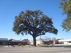
Giant oak tree in Downtown Pleasanton across from "Mr. Cowboy" sculpture | |
Location of Pleasanton, Texas | |
![]() | |
Coordinates: 28°57′52″N98°29′46″W / 28.96444°N 98.49611°W | |
Country | ![]() |
State | ![]() |
County | Atascosa |
Government | |
• Type | Council-Manager |
• City Council | Mayor Clinton J. Powell [ citation needed ] |
• City Manager | Johnny Huizar [ citation needed ] |
Area | |
• Total | 8.96 sq mi (23.20 km2) |
• Land | 8.96 sq mi (23.20 km2) |
• Water | 0.00 sq mi (0.00 km2) |
Elevation | 410 ft (120 m) |
Population (2020) | |
• Total | 10,648 |
• Estimate (2021) | 10,780 |
• Density | 1,200/sq mi (460/km2) |
Time zone | UTC-6 (Central (CST)) |
• Summer (DST) | UTC-5 (CDT) |
ZIP code | 78064 |
Area code | 830 |
FIPS code | 48-58280 [3] |
GNIS feature ID | 2411442 [2] |
Website | www |
Pleasanton is a city in Atascosa County, Texas, United States. The population was 8,934 at the 2010 census. [4] Pleasanton's official motto is "The City of Live Oaks and Friendly Folks." It is part of the San Antonio-New Braunfels Metropolitan Statistical Area.
Pleasanton was established in 1858 when conflicts with the Native Americans caused the settlers to move the location of the county seat from Amphion. The settlers chose the current townsite because of its location at the mouth of Bonita Creek. John Bowen (died 1867), San Antonio's first Anglo-American postmaster, founded and named the town of Pleasanton after his good friend and fellow early Texas Settler John Pleasants.
At one time Pleasanton had two newspapers, the Pleasanton Picayune, which became the Pleasanton Express in 1909, and the Pleasanton Reporter. The county seat was relocated from Pleasanton to Jourdanton in 1910. Pleasanton was incorporated in 1917. [5] [6]
In November 1957, the citizens of Pleasanton voted overwhelmingly to desegregate the public schools. This came some two months after the crisis at Little Rock Central High School in Arkansas. Some three dozen African American pupils were then integrated into the Pleasanton school. [7]
Pleasanton is located about 35 miles (56 km) south of downtown San Antonio, 110 miles (180 km) south-southwest of Austin and 110 miles (180 km) north by north-northwest of Corpus Christi.
According to the United States Census Bureau, the city has a total area of 8.5 square miles (22 km2), all land. [8]
The average annual temperature of Pleasanton is 70 °F (21 °C). The mean temperature on January 1 is 50 °F (10 °C) and on June 1 is 78 °F (26 °C). Average annual precipitation is 26.1 inches (660 mm).
Most soils of Pleasanton are quite sandy at the surface but have a clay-rich subsoil that holds moisture. They belong to the Alfisol soil order. Common soil series in town are Nusil, Poth and Rhymes. [9]
According to the Köppen Climate Classification system, Pleasanton has a humid subtropical climate, abbreviated "Cfa" on climate maps. The hottest temperature recorded in Pleasanton was 113 °F (45.0 °C) on June 15, 1998, and September 5, 2000, while the coldest temperature recorded was 9 °F (−12.8 °C) on January 10–11, 2010. [10]
Climate data for Pleasanton, Texas, 1991–2020 normals, extremes 1948–present | |||||||||||||
---|---|---|---|---|---|---|---|---|---|---|---|---|---|
Month | Jan | Feb | Mar | Apr | May | Jun | Jul | Aug | Sep | Oct | Nov | Dec | Year |
Record high °F (°C) | 89 (32) | 100 (38) | 101 (38) | 103 (39) | 105 (41) | 113 (45) | 108 (42) | 111 (44) | 113 (45) | 102 (39) | 94 (34) | 89 (32) | 113 (45) |
Mean maximum °F (°C) | 82.0 (27.8) | 86.8 (30.4) | 91.7 (33.2) | 95.3 (35.2) | 98.6 (37.0) | 101.9 (38.8) | 102.8 (39.3) | 104.1 (40.1) | 100.5 (38.1) | 95.1 (35.1) | 88.0 (31.1) | 82.4 (28.0) | 105.8 (41.0) |
Mean daily maximum °F (°C) | 65.1 (18.4) | 68.9 (20.5) | 75.7 (24.3) | 82.7 (28.2) | 88.6 (31.4) | 94.1 (34.5) | 96.4 (35.8) | 97.5 (36.4) | 91.8 (33.2) | 84.2 (29.0) | 73.7 (23.2) | 66.3 (19.1) | 82.1 (27.8) |
Daily mean °F (°C) | 52.5 (11.4) | 56.7 (13.7) | 63.7 (17.6) | 70.4 (21.3) | 77.8 (25.4) | 83.4 (28.6) | 85.3 (29.6) | 85.7 (29.8) | 80.5 (26.9) | 71.8 (22.1) | 61.7 (16.5) | 54.2 (12.3) | 70.3 (21.3) |
Mean daily minimum °F (°C) | 39.9 (4.4) | 44.4 (6.9) | 51.7 (10.9) | 58.1 (14.5) | 66.9 (19.4) | 72.7 (22.6) | 74.3 (23.5) | 73.9 (23.3) | 69.2 (20.7) | 59.4 (15.2) | 49.6 (9.8) | 42.0 (5.6) | 58.5 (14.7) |
Mean minimum °F (°C) | 25.5 (−3.6) | 28.7 (−1.8) | 32.9 (0.5) | 41.9 (5.5) | 51.8 (11.0) | 65.3 (18.5) | 68.9 (20.5) | 68.5 (20.3) | 56.4 (13.6) | 41.5 (5.3) | 32.1 (0.1) | 26.1 (−3.3) | 23.0 (−5.0) |
Record low °F (°C) | 9 (−13) | 11 (−12) | 22 (−6) | 33 (1) | 40 (4) | 59 (15) | 59 (15) | 60 (16) | 46 (8) | 32 (0) | 24 (−4) | 15 (−9) | 9 (−13) |
Average precipitation inches (mm) | 1.98 (50) | 1.76 (45) | 2.26 (57) | 2.36 (60) | 3.89 (99) | 3.79 (96) | 2.63 (67) | 2.46 (62) | 3.58 (91) | 2.72 (69) | 2.19 (56) | 1.91 (49) | 31.53 (801) |
Average snowfall inches (cm) | 0.0 (0.0) | 0.0 (0.0) | 0.0 (0.0) | 0.0 (0.0) | 0.0 (0.0) | 0.0 (0.0) | 0.0 (0.0) | 0.0 (0.0) | 0.0 (0.0) | 0.0 (0.0) | 0.0 (0.0) | 0.3 (0.76) | 0.3 (0.76) |
Average precipitation days (≥ 0.01 in) | 7.3 | 7.4 | 6.5 | 5.2 | 6.5 | 6.6 | 5.0 | 4.1 | 6.7 | 5.4 | 5.9 | 6.7 | 73.3 |
Average snowy days (≥ 0.1 in) | 0.0 | 0.0 | 0.0 | 0.0 | 0.0 | 0.0 | 0.0 | 0.0 | 0.0 | 0.0 | 0.0 | 0.1 | 0.1 |
Source 1: NOAA [11] | |||||||||||||
Source 2: National Weather Service [10] |
Census | Pop. | Note | %± |
---|---|---|---|
1870 | 206 | — | |
1880 | 393 | 90.8% | |
1890 | 367 | −6.6% | |
1920 | 1,036 | — | |
1930 | 1,154 | 11.4% | |
1940 | 2,074 | 79.7% | |
1950 | 2,913 | 40.5% | |
1960 | 3,467 | 19.0% | |
1970 | 5,407 | 56.0% | |
1980 | 6,346 | 17.4% | |
1990 | 7,678 | 21.0% | |
2000 | 8,266 | 7.7% | |
2010 | 8,934 | 8.1% | |
2020 | 10,648 | 19.2% | |
2021 (est.) | 10,780 | [12] | 1.2% |
U.S. Decennial Census [13] |
Race | Number | Percentage |
---|---|---|
White (NH) | 4,322 | 40.59% |
Black or African American (NH) | 74 | 0.69% |
Native American or Alaska Native (NH) | 33 | 0.31% |
Asian (NH) | 55 | 0.52% |
Pacific Islander (NH) | 3 | 0.03% |
Some Other Race (NH) | 28 | 0.26% |
Mixed/Multi-Racial (NH) | 261 | 2.45% |
Hispanic or Latino | 5,872 | 55.15% |
Total | 10,648 |
As of the 2020 United States census, there were 10,648 people, 3,462 households, and 2,558 families residing in the city.
As of the census [3] of 2000, there were 8,266 people, 2,941 households, and 2,135 families residing in the city. The population density was 1,293.5 inhabitants per square mile (499.4/km2). There were 3,212 housing units at an average density of 502.6 per square mile (194.1/km2). The racial makeup of the city was 79.13% White, 0.98% African American, 0.97% Native American, 0.50% Asian, 0.17% Pacific Islander, 15.34% from other races, and 2.92% from two or more races. Hispanic or Latino of any race were 51.15% of the population.
There were 2,941 households, out of which 39.0% had children under the age of 18 living with them, 52.8% were married couples living together, 15.0% had a female householder with no husband present, and 27.4% were non-families. 23.7% of all households were made up of individuals, and 11.7% had someone living alone who was 65 years of age or older. The average household size was 2.77 and the average family size was 3.28.
In the city, the population was spread out, with 30.4% under the age of 18, 9.0% from 18 to 24, 27.1% from 25 to 44, 19.9% from 45 to 64, and 13.6% who were 65 years of age or older. The median age was 33 years. For every 100 females, there were 90.7 males. For every 100 females age 18 and over, there were 87.2 males.
The median income for a household in the city was $29,644, and the median income for a family was $34,718. Males had a median income of $28,849 versus $20,144 for females. The per capita income for the city was $14,878. About 16.8% of families and 22.2% of the population were below the poverty line, including 30.9% of those under age 18 and 21.8% of those aged 65 or over.
Part of the film The Sugarland Express was filmed around the intersection of 2nd Street and Commerce Street.[ citation needed ]
Every year in October, Pleasanton hosts the "Cowboy Homecoming Festival", which commemorates the time when the cowboys driving cattle from South Texas to the railheads up north would return home.[ citation needed ]
Almost all of Pleasanton is located within the Pleasanton Independent School District and home to the Pleasanton High School Eagles. In the school year 2010–2011, Pleasanton I.S.D. received Academically Unacceptable ratings from the Texas Education Agency for their high school campus and their school of choice. The school district received an Acceptable rating for their junior high and Exceptional for the elementary and primary campuses. Under the current Texas accountability system, on a A-F rating scale, Pleasanton I.S.D. is rated "B". A small portion of the town is in the Jourdanton Independent School District.
Coastal Bend College of Beeville maintains a branch two-year campus in Pleasanton.
Medina County is a county located in the U.S. state of Texas. As of the 2020 census, its population was 50,748. Its county seat is Hondo. The county is named for the Medina River. The extreme northern part of the county lies within the Edwards Plateau, which elevates into the Texas Hill Country. The Medina Dam, the fourth largest in the nation when completed in 1913, is listed on the National Register of Historic Places. The irrigation project, creating Medina Lake, was built by 1500 skilled workers who worked in shifts operating 24 hours a day to complete the dam in two years. Medina County is part of the San Antonio, TX Metropolitan Statistical Area.
Bee County is a county located in the U.S. state of Texas. It is in South Texas and its county seat is Beeville. As of the 2020 census, its population was 31,047. The Beeville, TX micropolitan statistical area includes all of Bee County. The county was founded December 8, 1857, and organized the next year. It is named for Barnard E. Bee, Sr., a secretary of state of the Republic of Texas.
Atascosa County is a county located in the U.S. state of Texas. It is in South Texas and its county seat is Jourdanton.
Christine is a town in Atascosa County, Texas, United States. The population was 337 at the 2020 census. It is part of the San Antonio Metropolitan Statistical Area.
Jourdanton is a city in and the county seat of Atascosa County, Texas, United States. The population is 4,094. It is part of the San Antonio metropolitan statistical area.
Lakehills is a census-designated place (CDP) in Bandera County, Texas, United States. The population was 5,295 at the 2020 census, making it the most populous place in Bandera County. It is part of the San Antonio Metropolitan Statistical Area.
Beeville is a city in Bee County, Texas, United States. Its population of 13,543 at the 2020 census makes it the 207th-largest city in Texas. It is the county seat of Bee County and home to the main campus of Coastal Bend College. The area around the city contains three prisons operated by the Texas Department of Criminal Justice.
Blueberry Hill is a census-designated place (CDP) in Bee County, Texas, United States. The population was 844 at the 2020 census. It is located just outside Beeville and has no services of its own. Drinking water and garbage services are provided by the city of Beeville. Mailing addresses for Blueberry Hill are labeled "Beeville".
Cross Mountain is a census-designated place (CDP) in Bexar County, Texas, United States. The population was 3,944 at the 2020 census, an increase over the figure of 3,124 tabulated in 2010. It is part of the San Antonio Metropolitan Statistical Area.
Leon Valley is a city in Bexar County, Texas, United States. It is an enclave on the northwestern side of San Antonio and is part of the San Antonio-New Braunfels metropolitan statistical area. Its population was 11,542 at the 2020 census. Leon Valley is an independent municipality surrounded by the city of San Antonio.
Somerset is a city in Bexar County, Texas, United States. It is located less than 20 miles south of Downtown San Antonio and is part of the San Antonio–New Braunfels metropolitan area. The population was 1,756 at the 2020 census.
Terrell Hills is a city in Bexar County, Texas, United States; it is located 5 miles (8 km) northeast of downtown San Antonio. As of the 2020 census Terrell Hills had a population of 5,045.
Windcrest is a city in Bexar County, Texas, United States. Its population was 5,865 at the 2020 census. It is part of the San Antonio metropolitan area.
Dilley is a town in Frio County, Texas, United States. The population was 3,274 at the 2020 census. It is located off Interstate 35, south of the county seat in Pearsall.
Karnes City is a city in and county seat of Karnes County, Texas, United States. The population was 3,111 at the 2020 census, up from 3,042 at the 2010 census. The town was named after Henry Karnes of the Texas Revolution. Karnes is 24 miles (39 km) southeast of Floresville and 54 miles (87 km) southeast of San Antonio on U.S. Highway 181.
Kenedy is a city in Karnes County, Texas, United States, named for Mifflin Kenedy, who bought 400,000 acres (1,600 km2) and wanted to develop a new town that would carry his name. The population was 3,473 at the 2020 census, up from 3,296 at the 2010 census.
George West is a city in Live Oak County, Texas, United States, and named for cattle rancher George Washington West. The population was 2,171 at the 2020 census. It is the county seat of Live Oak County. George West was named the "storytelling capital of Texas" in 2005 by the Texas Senate; and it hosts the George West Storyfest, a festival that features storytelling, cowboy poetry, and music. Numerous ranches surround George West.
Natalia is a city in Medina County, Texas, United States. The population was 1,202 at the 2020 census. It was founded in 1912 and was named after Natalie Pearson Nicholson, daughter of Frederick Stark Pearson, engineer, designer and builder of the Medina Dam.
Fair Oaks Ranch is a city in Bexar, Comal, and Kendall counties in the U.S. state of Texas. The population was 9,833 at the 2020 census, and an estimated 10,505 in 2021. It is part of the San Antonio-New Braunfels Metropolitan Statistical Area. The city was named after Ralph Fair Sr, an oilman who had a large cattle ranch on the now residential town. The Fair family decided to sell a portion of the ranch to build what is now Fair Oaks Ranch in 1975.
Greater San Antonio, officially designated San Antonio–New Braunfels, is an eight-county metropolitan area in the U.S. state of Texas defined by the Office of Management and Budget (OMB). The metropolitan area straddles South Texas and Central Texas and is on the southwestern corner of the Texas Triangle. The official 2020 U.S. census showed the metropolitan area's population at 2,558,143—up from a reported 1,711,103 in 2000—making it the 24th largest metropolitan area in the United States. Downtown Austin and Downtown San Antonio are approximately 80 miles (129 km) apart, and both fall along the Interstate 35 corridor. This combined metropolitan region of San Antonio–Austin has approximately 5 million people.