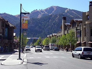
Ketchum is a city in Blaine County, Idaho, United States. Located in the central part of the state, the population was 3,555 at the 2020 census, up from 2,689 in 2010. Located in the Wood River Valley, Ketchum is adjacent to Sun Valley and the communities share many resources: both sit in the same valley beneath Bald Mountain, with its skiing. The city also draws tourists to its fishing, hiking, trail riding, tennis, shopping, art galleries, and more. The airport for Ketchum, Friedman Memorial Airport, is approximately 15 miles (24 km) south in Hailey.

Timberwood Park is a census-designated place (CDP) in far northern unincorporated Bexar County, Texas, United States and located within the southern edge of the Texas Hill Country. The district has roughly 42 miles of roads and encompasses over 2,000 acres. The overall plan shows 3,263 platted lots. The population was 35,217 at the 2020 census, up from 13,447 at the 2010 census. It is part of the San Antonio Metropolitan Statistical Area.

The City of Bulverde is located in Comal County in the State of Texas. Bulverde is known for its small-town, slow pace of life, coupled with the German emigrant history of the town's founders. Bulverde was originally named Piepers Settlement after a prominent German pioneer. Its population was 5,692 at the 2020 census, up from 4,630 at the 2010 census. Since 2000, Bulverde’s population has grown by nearly 33 percent. It is part of the San Antonio metropolitan statistical area.

Canyon Lake is a census-designated place (CDP) in Comal County, Texas, United States. The population was 31,124 at the 2020 census. It is part of the San Antonio Metropolitan Statistical Area.
Katy is a city in the U.S. state of Texas. It is in the Greater Katy area, itself forming the western part of the Greater Houston metropolitan area. Homes and businesses may have Katy postal addresses without being in the City of Katy. The city of Katy is approximately centered at the tripoint of Harris, Fort Bend, and Waller counties. The population was 21,894 at the 2020 census.
Friendswood is a city in the U.S. state of Texas. It is part of the Greater Houston metropolitan area. The city lies in Galveston and Harris counties. As of the 2020 census, the population of Friendswood was 41,213.

Big Bend National Park is a national park of the United States located in West Texas, bordering Mexico. The park has national significance as the largest protected area of Chihuahuan Desert topography and ecology in the United States, and was named after a large bend in the Rio Grande/Río Bravo. The park protects more than 1,200 species of plants, more than 450 species of birds, 56 species of reptiles, and 75 species of mammals. Additional park activities include scenic drives, programs led by Big Bend park rangers, and stargazing.

The Santa Clarita Valley (SCV) is part of the upper watershed of the Santa Clara River in Southern California. The western portion of the valley was part of the 48,612-acre (19,673 ha) Rancho San Francisco Mexican land grant. Located in Los Angeles County. The valley's main population center is the city of Santa Clarita which includes the neighborhoods of Canyon Country, Newhall, Saugus, and Valencia. Adjacent unincorporated communities include Castaic, Stevenson Ranch, Val Verde, and Valencia.

Topanga is an unincorporated community in western Los Angeles County, California, United States. Located in the Santa Monica Mountains, the community exists in Topanga Canyon and the surrounding hills. The narrow southern portion of Topanga at the coast is between the city of Malibu and the Los Angeles neighborhood of Pacific Palisades. As of the 2020 census the population of the Topanga CDP was 8,560. For statistical purposes, the United States Census Bureau has defined Topanga as a census-designated place (CDP). The ZIP code is 90290 and the area code is primarily 310, with 818 only at the north end of the canyon. It is in the 3rd County Supervisorial district.
Comal Independent School District is a public school district based in New Braunfels, Texas (USA).

Spring Branch is a city in Comal County, Texas, United States. It has approximately 250 residents. The community voted to incorporate in an election held on November 3, 2015 and Spring Branch officially became a city on November 19, 2015.
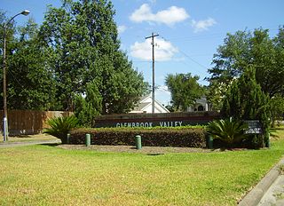
Glenbrook Valley is a subdivision located in Houston, Texas, United States.

Andy Dekaney High School is a public secondary school located at 22351 Imperial Valley Drive and Bammel Road in unincorporated Harris County, Texas, United States, with a ZIP code of 77073.
Canyon City is a neighborhood within the Canyon Lake census-designated place in Comal County, Texas, United States. According to the Handbook of Texas, the community had a population of 100 in 2000. It is located within the Greater San Antonio area.

Smithson Valley High School is a public high school located in unincorporated Comal County, Texas, and is classified as a 5A school by the UIL. It is part of the Comal Independent School District and is one of the five out of seven traditional high schools within the district. Its student enrollment as of the beginning of the 2022-23 school year is 2,310. Smithson Valley’s student enrollment reached as high as 2,584 in the 2021-22 school year before some students were sent off to the brand-new and recently opened Pieper High School after the 2021-22 school year which was built to deal with the growing population of the school’s attendance zone and to provide relief to Smithson Valley's attendance roster.

Umbarger is a census-designated place in Randall County, Texas, United States. According to the Handbook of Texas, the community had an estimated population of 327 in 2000. The community is part of the Amarillo, Texas Metropolitan Statistical Area.
The Airline Improvement District is a management district in unincorporated Harris County, Texas, United States, in Greater Houston and is located entirely within the postal zip code of 77037.
Ponderosa Forest is a residential neighborhood in unincorporated northwestern Harris County, Texas, United States. It is located near Farm to Market Road 1960, also referred to as Cypress Creek Parkway.
Tetragramma is a genus of fossil sea urchins known from the Upper Jurassic (Oxfordian) to the Upper Cretaceous (Turonian).
Tetragramma donaldtrumpi is a species of fossil sea urchins discovered and identified by William R. Thompson Jr. in 2016. The specimen locality is from the Lower Cretaceous, Trinity Group, of the Glen Rose Formation near Fischer, Texas, in the United States.


