Related Research Articles

Calaveras County, officially the County of Calaveras, is a county in both the Gold Country and High Sierra regions of the U.S. state of California. As of the 2020 census, the population was 45,292. The county seat is San Andreas. Angels Camp is the county's only incorporated city. Calaveras is Spanish for "skulls"; the county was reportedly named for the remains of Native Americans discovered by the Spanish explorer Captain Gabriel Moraga.
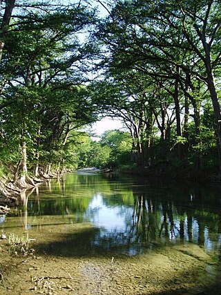
Medina Valley, also known as the Medina River Valley, is an area in south central Texas containing the Medina River, Lake Medina, and the Medina Dam. It serves to drain the Balcones Escarpment of the Texas Hill Country and irrigate the crop fields contained therein. It is approximately 120 miles long and is named for the Medina River.
Kicaster is an unincorporated community in northwestern Wilson County, Texas, United States.
Kicaster Creek is a short stream in Wilson County, Texas. The creek begins in the recharge zone for the Carrizo-Wilcox Aquifer, near Kicaster, six miles southwest of the town of La Vernia. It flows through the Sand Hills Region of Wilson County for eleven miles southeastward to its mouth three miles northwest of the town of Floresville on the San Antonio River.

The San Saba River is a river in Texas, United States. It is an undeveloped and scenic waterway located on the northern boundary of the Edwards Plateau.
Rio Medina or Riomedina is an unincorporated community in Medina County, Texas, United States. It is located approximately six miles north of Castroville and is part of the San Antonio Metropolitan Statistical Area. According to the 2006–07 Texas Almanac, it had a population of 60 people in 2000. According to an online community profile, Rio Medina has a population of 541 people.

The Texas Neurosciences Institute (TNI) is the name of a medical office building in San Antonio, Texas.
Fratt, Texas was a flag station and farming settlement of mostly German settlers in northeastern Bexar County, Texas, United States, near the intersections of Interstate 35 and Loop 410 in San Antonio on the city's northeastern side. It was founded shortly before 1900, and in the 1930s had amenities such as a store and church. The population had declined to 25 people by late 1946, and by the 1960s was so depopulated that it was no longer found on maps.
Martinez is an unincorporated community in eastern Bexar County, Texas, United States. In 1990, its population was reported to be 75 residents. It is located within the Greater San Antonio metropolitan area.
Calaveras is an American community located in Wilson County, Texas, United States. The population is approximately 100.
Burson is an unincorporated community in Calaveras County, California. It lies at an elevation of 98 feet. Although unincorporated, Burson has the ZIP code of 95225.
Greasertown is a former gold rush settlement in Calaveras County, 4 miles (6.4 km) west of San Andreas, on the west side of the Calaveras River. It was first mentioned in a newspaper in 1851. When it caught fire the next year, "Spanish incendiaries" were blamed which so angered the locals that they drove out all the Hispanics they could find. However, it survived at least until 1868. It was submerged when the first Hogan Dam on the Calaveras River was built in the late 1920s. Greasertown was not renamed Petersburg; they were separate communities a mile apart. Petersburg was founded in 1858.
Cecil Ballow Baseball Complex is the home to the Tarleton State Texans baseball team in Stephenville, Texas. The field is natural grass, and seated capacity is 550. The stadium opened in 1988 just after completion.
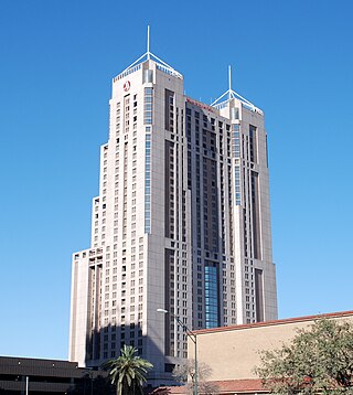
Marriott Rivercenter is a hotel located in San Antonio, Texas, USA. At a tip height of 546 feet, the 38-floor hotel is the tallest building in San Antonio and second tallest structure in the city. It is also the tallest hotel in Texas outside of Dallas. Its roof height, however, is 441 feet, 3 feet shorter than the Weston Centre.
Palo Pinto Creek is a river in Eastland, Stephens, and Palo Pinto counties, Texas, United States. It is a tributary of the Brazos River.
The Heart of Texas Wildlife Trail is a state-designated system of trails and wildlife sanctuaries in Central Texas in the United States. It is one of the four major wildlife trail systems designated by the State of Texas.
Poverty Bar is a former settlement in Calaveras County, California, active from c. 1850s to 1862, and now covered by the waters of Camanche Reservoir. The nearest major town is Campo Seco, California.

NNE1 (also known as NNEI, MN-24 and AM-6527) is an indole-based synthetic cannabinoid, representing a molecular hybrid of APICA and JWH-018 that is an agonist for the cannabinoid receptors, with Ki values of 60.09 nM at CB1 and 45.298 nM at CB2 and EC50 values of 9.481 nM at CB1 and 1.008 nM at CB2. It was invented by Abbott and has a CB1 receptor pEC50 of 8.9 with around 80x selectivity over the related CB2 receptor. It is suspected that metabolic hydrolysis of the amide group of NNE1 may release 1-naphthylamine, a known carcinogen, given the known metabolic liberation (and presence as an impurity) of amantadine in the related compound APINACA, and NNE1 was banned in New Zealand in 2012 as a temporary class drug to stop it being used as an ingredient in then-legal synthetic cannabis products. NNE1 was subsequently found to be responsible for the death of a man in Japan in 2014.

Smeltertown was a residential community in El Paso County, Texas, housing the workers of the ASARCO smelter and their families, between El Paso and the Texas borders with Mexico and New Mexico.
Parita Creek is a stream in southeastern Bexar County, Texas. The stream rises near Adkins and runs southwest for ten miles before meeting Calaveras Creek near Elmendorf.
References
- ↑ Texas Handbook Online June 6, 2001.
29°13′12″N98°15′55″W / 29.2201°N 98.2654°W
 | This article about a location in Bexar County, Texas is a stub. You can help Wikipedia by expanding it. |
| | This article related to a river in Texas is a stub. You can help Wikipedia by expanding it. |