
The Sabine River is a 360-mile (580 km) long river in the Southern U.S. states of Texas and Louisiana, From the 32nd parallel north and downstream, it serves as part of the boundary between the two states and empties into Sabine Lake, an estuary of the Gulf of Mexico.

Kerr County is a county located on the Edwards Plateau in the U.S. state of Texas. As of the 2020 census, its population was 52,598. Its county seat is Kerrville. The county was named by Joshua D. Brown for his fellow Kentucky native, James Kerr, a congressman of the Republic of Texas. The Kerrville, TX Micropolitan Statistical Area includes all of Kerr County.
Scouting in Texas has a long history, from the 1910s to the present day, serving thousands of youth in programs that suit the environment in which they live. Scouting, also known as the Scout Movement, is a worldwide youth movement with the stated aim of supporting young people in their physical, mental and spiritual development, so that they may play constructive roles in society.
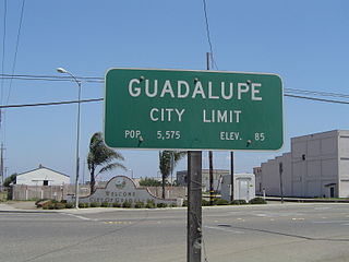
Guadalupe is a small city located in Santa Barbara County, California. According to the 2010 census, the city has a population of 7,080. Guadalupe is economically and socially tied to the city of Santa Maria, which is about 8 miles (13 km) to the east. It is located at the intersection of Highway 1 and Highway 166, immediately south of the Santa Maria River, and 5 miles (8 km) east of the Pacific Ocean.

Hillsboro is a small city in Traill County, North Dakota. It is the county seat of Traill County. The population was 1,649 at the 2020 census. Hillsboro was founded in 1881.
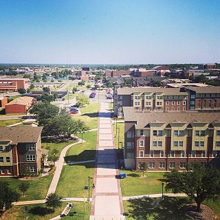
Commerce is a city in Hunt County, Texas, United States, situated on the eastern edge of North Texas and the western edge of East Texas, in the heart of the Texas Blackland Prairies. The town is 45 miles (72 km) south of the Texas/Oklahoma border. Commerce is the second-largest city in Hunt County, with a population of 9,090 at the 2020 census. The city is home to Texas A&M University–Commerce, a four-year university of more than 12,000 students that has been in the town since 1894. Commerce is one of the smallest college towns in Texas.
Ingram is a city in Kerr County, Texas, United States. The population was 1,787 at the 2020 census, and 1,804 at the 2010 census.

Kerrville is a city in, and the county seat of Kerr County, Texas, United States. The population of Kerrville was 24,278 at the 2020 census. Kerrville is named after James Kerr, a major in the Texas Revolution, and friend of settler-founder Joshua Brown, who settled in the area to start a shingle-making camp.

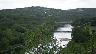
The Texas Hill Country is a geographic region of Central and South Texas, forming the southeast part of the Edwards Plateau. Given its location, climate, terrain, and vegetation, the Hill Country can be considered the border between the American Southeast and Southwest. The region represents the very remote rural countryside of Central Texas, but also is home to growing suburban neighborhoods and affluent retirement communities.
Stonehenge II is a concrete sculpture in the Texas Hill Country, US, built in homage to the original Stonehenge monument. Stonehenge II was conceived by Al Shepperd and built with the help of his friend and neighbor, Doug Hill. Originally located on FM 1340 west of Hunt, Texas, Stonehenge II now resides on the campus of the Hill Country Arts Foundation in Ingram, Texas (78025).

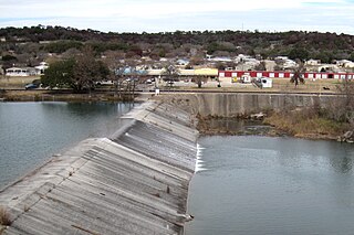
The Guadalupe River runs from Kerr County, Texas, to San Antonio Bay on the Gulf of Mexico, with an average temperature of 17.75 degrees Celsius. It is a popular destination for rafting, fly fishing, and canoeing. Larger cities along it include Kerrville, New Braunfels, Seguin, Gonzales, Cuero, and Victoria. It has several dams along its length, the most notable of which, Canyon Dam, forms Canyon Lake northwest of New Braunfels.

West Dallas is an area consisting of many communities and neighborhoods in Dallas, Texas, United States. West Dallas lies just west of Downtown Dallas, north of Oak Cliff, and east of Irving and Grand Prairie.

Circle Ten Council is a Boy Scouts of America (BSA) chartered council in central north Texas and a portion of Oklahoma. It encompasses all or parts of: Camp, Collin, Dallas, Delta, Ellis, Fannin, Franklin, Grayson, Henderson, Hopkins, Hunt, Kaufman, Lamar, Morris, Navarro, Rains, Red River, Rockwall, Titus, and Van Zandt counties in Texas as well as Bryan, Choctaw, McCurtain, and Pushmataha counties in Oklahoma. Founded in 1913 and based in Dallas, approximately 34,000 youth and 7,800 adults participate in Scouting through the council each year. The council has four camps - Camp Wisdom, Camp James Ray, Clements Scout Ranch / Camp Trevor Rees-Jones and Camp Constantin / Jack D. Furst Aquatics Base. The Order of the Arrow is represented by Mikanakawa Lodge.

U.S. Route 183 (US 183) is a north-south U.S. highway that begins in Texas in Refugio at an intersection with US 77 concurrent with US 77 Alt. The highway runs through many small communities with Austin being the only major city along its route. The highway exits Texas concurrent with US 70, crossing into Oklahoma.
Mo Ranch is a Presbyterian conference center for summer camps, retreats, family reunions that is located in unincorporated Kerr County, Texas. It is in a west-central area in the county, 10 miles (16 km) west of Hunt, Texas, in the Hill Country at the North Fork of the Guadalupe River.
Tepotzotlán is a city and a municipality in the Mexican state of Mexico. It is located 40 km (25 mi) northwest of Mexico City about a 45-minute drive along the Mexico City-Querétaro at marker number 41. In Aztec times, the area was the center of a dominion that negotiated to keep most of its independence in return with being allied with the Aztec Triple Alliance. Later, it would also be part of a "Republic of the Indians," allowing for some autonomy under Spanish rule as well. The town became a major educational center during the colonial period when the Jesuits established the College of San Francisco Javier. The college complex that grew from its beginnings in 1580 would remain an educational center until 1914. Today this complex houses the Museo del Virreinato, with one of the largest collections of art and other objects from this time period.

La Garita is a town in the Mexican state of Jalisco in the Municipality of Tamazula de Gordiano. According to INEGI 2010 national census it pegged the town's population at 1,060 people. A special census done by the INEGI government agency estimated the population to be at 1,278 in 2005. Although this number seems low, about 1,000 people from La Garita now reside in the United States with the most living in California, Illinois, Texas, Florida, and New York. The city of Joliet, Illinois now is the destination for most of the emigrants from this town. Others have migrated to nearby cities like Tamazula de Gordiano, Ciudad Guzman, and Guadalajara.

State Highway Loop 98 (Loop 98) is a state highway loop in Kerrville, Texas, in the Texas Hill Country. It runs 3.4 miles (5.5 km) from Farm to Market Road 1338 (FM 1338) to State Highway 16 (SH 16). Loop 98 was established in 2010 as a redesignation of Spur 98.


