
The Pastry War, also known as the first French intervention in Mexico or the first Franco-Mexican war (1838–1839), began in November 1838 with the naval blockade of some Mexican ports and the capture of the fortress of San Juan de Ulúa in the port of Veracruz by French forces sent by King Louis Philippe I. It ended in March 1839 with a British-brokered peace. The intervention followed many claims by French nationals of losses due to unrest in Mexico. This would be the first of two French invasions of Mexico; a second, larger intervention would take place in the 1860s.

Corpus Christi is a coastal city in the South Texas region of the U.S. state of Texas and the county seat and largest city of Nueces County, it also extends into Aransas, Kleberg, and San Patricio Counties. It is 130 miles (210 km) southeast of San Antonio. Its political boundaries encompass Nueces Bay and Corpus Christi Bay. Its zoned boundaries include small land parcels or water inlets of three neighboring counties.

South Texas is a region of the U.S. state of Texas that lies roughly south of—and includes—San Antonio. The southern and western boundary is the Rio Grande, and to the east it is the Gulf of Mexico. The population of this region is about 4.96 million according to the 2017 census estimates. The southern portion of this region is often referred to as the Rio Grande Valley. The eastern portion along the Gulf of Mexico is also referred to as the Coastal Bend.

Aransas Bay is a bay on the Texas Gulf Coast, approximately 30 miles (48 km) northeast of Corpus Christi, and 173 miles (278 km) south of San Antonio. It is separated from the Gulf of Mexico by San José Island. Aransas Pass is the most direct navigable outlet into the Gulf of Mexico from the bay. The cities of Aransas Pass and Port Aransas are located at the southern end, and Rockport is found on the central western shore. The bay is oriented laterally northeast–southwest, and is extended by Redfish Bay to the southwest, Copano Bay to the west, Saint Charles Bay to the north, and Mesquite Bay to the northeast. Aransas Bay is part of the Mission-Aransas National Estuarine Research Reserve.

The Texas Coastal Bend, or just the Coastal Bend, is a geographical region in the US state of Texas. The name refers to the area being a curve along the Texas Gulf Coast of the Gulf of Mexico. The largest city of the Coastal Bend is Corpus Christi. It includes the Nueces Estuary and the Mission–Aransas Estuary, as well as part of Laguna Madre. The coastline is paralleled by several of the Texas barrier islands, including North Padre Island, Mustang Island, and San José Island.

Corpus Christi Bay is a scenic semi-tropical bay on the Texas coast found in San Patricio and Nueces counties, next to the major city of Corpus Christi. It is separated from the Gulf of Mexico by Mustang Island, and is fed by the Nueces River and Oso Creek from its western and southern extensions, Nueces Bay and Oso Bay. The bay is located approximately 136 miles (219 km) south of San Antonio, and 179 miles (288 km) southwest of Houston.

State Highway 358 is a Texas state highway that runs along the southern edge of Corpus Christi. The access road for Highway 358 is known as South Padre Island Drive (SPID). The official division is FM 665.
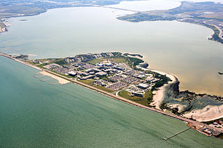
Ward Island is a small body of land situated at the confluence of Corpus Christi Bay and Oso Bay and is part of the city of Corpus Christi, Texas. Most of Ward Island is now used by Texas A&M University-Corpus Christi.
USS Belle Italia was a sloop captured by the Union Navy during the American Civil War. She was used by the Union Navy as a gunboat in support of the Union Navy blockade of Confederate waterways.
USS Arthur was a bark acquired by the Union Navy during the American Civil War. She was used by the Union Navy as a gunboat in support of the Union Navy blockade of Confederate waterways.
USS Breaker was a schooner captured by the Union Navy during the American Civil War. She was used by the Union Navy as a gunboat in support of the Union Navy blockade of Confederate waterways.
Oso Bay is a bay bordered by Corpus Christi, Texas. The bay is fed freshwater by Oso Creek and saltwater from Corpus Christi Bay. The Hans and Pat Suter Wildlife Refuge is located on the bay's western shore near the Pharaoh Valley subdivision, Naval Air Station Corpus Christi is located on its eastern shore in Flour Bluff, newly created Skimmer Key is located between the Oso Bay Bridge and the Naval Air Station, and Texas A&M University - Corpus Christi on Ward Island is located on the northern shore of Oso Bay. On the bay’s southwestern shore is the Oso Bay Wetlands Preserve.
Nueces Bay is a northwestern extension of Corpus Christi Bay in the San Patricio and Nueces Counties of Texas. The bay is fed by the Nueces River, forming a natural estuary, which renders it ecologically and economically vital to the surrounding area. It serves as a habitat for the propagation of fish and shellfish, which sustain diverse species of birds and other wildlife. The bay is threatened by pollution from the heavy industry on its southern shore, which prevents oyster farming. Petrochemical production and oil are important to the surrounding economies of the major settlements of Corpus Christi and Portland, found on the eastern shore and connected by the Nueces Bay Causeway at the bay's confluence with Corpus Christi Bay.
The John F. Kennedy Memorial Causeway is a paved highway located in Corpus Christi, Texas. The causeway crosses the Laguna Madre and connects North Padre Island with Flour Bluff on the Texas mainland.

Corpus Christi is a coastal city in the South Texas region of the U.S. state of Texas. The county seat of Nueces County, it also extends into Aransas, Kleberg, and San Patricio counties. The population was 277,454 at the 2000 census; in 2006 the U.S. Census Bureau estimated the city's population at 285,175, making it the eighth-largest city in the state. It is the principal city of the three-county Corpus Christi Metropolitan Statistical Area as well as the larger Corpus Christi-Kingsville Combined Statistical Area. The translation from Latin of the city's name is Body of Christ, given to the settlement by the Spanish, in honor of the Blessed Sacrament (Eucharist). The city has been nicknamed The Sparkling City by the Sea, or "Corpitos" particularly in literature promoting tourism.

The Laguna Madre is a long, shallow, hypersaline lagoon along the western coast of the Gulf of Mexico in Nueces, Kenedy, Kleberg, Willacy and Cameron Counties in Texas, United States. It is one of seven major estuaries along the Gulf Coast of Texas. The roughly 20-mile (32 km) long Saltillo Flats land bridge divides it into Upper and Lower lagoons joined by the Intracoastal Waterway, which has been dredged through the lagoon. Cumulatively, Laguna Madre is approximately 130 miles (210 km) long, the length of Padre Island in the US. The main extensions include Baffin Bay in Upper Laguna Madre, Red Fish Bay just below the Saltillo Flats, and South Bay near the Mexican border. As a natural ecological unit, the Laguna Madre of the United States is the northern half of the ecosystem as a whole, which extends into Tamaulipas, Mexico approximately 144 miles (232 km) south of the US border, to the vicinity of the Rio Soto La Marina and the town of La Pesca, extending approximately 275 miles (443 km) through USA and Mexico in total.

Oso Creek is a creek in the U.S. state of Texas. It runs just south of Corpus Christi.
The following is a timeline of the history of the city of Corpus Christi, Texas, USA.

The U.S. state of Texas has a series of estuaries along its coast on the Gulf of Mexico, most of them bounded by the Texas barrier islands. Estuaries are coastal bodies of water in which freshwater from rivers mixes with saltwater from the sea. Twenty-one drainage basins terminate along the Texas coastline, forming a chain of seven major and five minor estuaries: listed from southwest to northeast, these are the Rio Grande Estuary, Laguna Madre, the Nueces Estuary, the Mission–Aransas Estuary, the Guadalupe Estuary, the Colorado–Lavaca Estuary, East Matagorda Bay, the San Bernard River and Cedar Lakes Estuary, the Brazos River Estuary, Christmas Bay, the Trinity–San Jacinto Estuary, and the Sabine–Neches Estuary. Each estuary is named for its one or two chief contributing rivers, excepting Laguna Madre, East Matagorda Bay, and Christmas Bay, which have no major river sources. The estuaries are also sometimes referred to by the names of their respective primary or central water bodies, though each also includes smaller secondary bays, inlets, or other marginal water bodies.