Lockesburg, Arkansas | |
---|---|
Coordinates: 33°58′11″N94°10′16″W / 33.96972°N 94.17111°W | |
Country | United States |
State | Arkansas |
County | Sevier |
Area | |
• Total | 3.49 sq mi (9.03 km2) |
• Land | 3.48 sq mi (9.02 km2) |
• Water | 0.00 sq mi (0.01 km2) |
Elevation | 400 ft (100 m) |
Population (2020) | |
• Total | 594 |
• Density | 170.49/sq mi (65.84/km2) |
Time zone | UTC-6 (Central (CST)) |
• Summer (DST) | UTC-5 (CDT) |
ZIP code | 71846 |
Area code | 870 |
FIPS code | 05-41090 |
GNIS feature ID | 2404945 [2] |
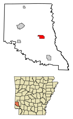
Lockesburg is a city in Sevier County, Arkansas, United States. [3] The population was 739 at the 2010 census.
Though Lockesburg became the county seat on January 18, 1869, it was not incorporated until November 7, 1878. [4] The land was donated by three members of a prominent local family—James, William, and Matthew Locke—and one Royal Appleton, for creation of a new county seat after an area of Sevier County was carved away to become part of newly created Little River County, and the existing county seat, Paraclifta, was no longer centrally located. [4] The town’s growth was stunted when a major railroad bypassed the town for De Queen in 1897, along with a subsequent loss of county seat status to De Queen in 1905. [4] But the timber industry served to boost the fortunes of the town in the 20th century. [4]
Lockesburg is located at 33°58′11″N94°10′16″W / 33.96972°N 94.17111°W (33.969852, -94.171034). [5]
According to the United States Census Bureau, the town has a total area of 3.5 square miles (9.1 km2), all land.
Census | Pop. | Note | %± |
---|---|---|---|
1880 | 256 | — | |
1890 | 451 | 76.2% | |
1900 | 550 | 22.0% | |
1910 | 748 | 36.0% | |
1920 | 794 | 6.1% | |
1930 | 747 | −5.9% | |
1940 | 764 | 2.3% | |
1950 | 714 | −6.5% | |
1960 | 511 | −28.4% | |
1970 | 620 | 21.3% | |
1980 | 616 | −0.6% | |
1990 | 608 | −1.3% | |
2000 | 711 | 16.9% | |
2010 | 739 | 3.9% | |
2020 | 594 | −19.6% | |
U.S. Decennial Census [6] |
As of the census [7] of 2000, there were 711 people, 276 households, and 197 families residing in the town. The population density was 201.1 inhabitants per square mile (77.6/km2). There were 328 housing units at an average density of 92.8 per square mile (35.8/km2). The racial makeup of the town was 92.55% White, 4.50% Black or African American, 2.25% from other races, and 0.70% from two or more races. 2.95% of the population were Hispanic or Latino of any race.
There were 276 households, out of which 37.3% had children under the age of 18 living with them, 56.2% were married couples living together, 10.9% had a female householder with no husband present, and 28.6% were non-families. 25.4% of all households were made up of individuals, and 13.0% had someone living alone who was 65 years of age or older. The average household size was 2.58 and the average family size was 3.09.
In the town the population had 30.8% under the age of 18, 9.3% from 18 to 24, 26.7% from 25 to 44, 20.4% from 45 to 64, and 12.8% who were 65 years of age or older. The median age was 31 years. For every 100 females, there were 94.8 males. For every 100 females age 18 and over, there were 87.1 males.
The median income for a household in the town was $27,132, and the median income for a family was $31,625. Males had a median income of $25,729 versus $17,813 for females. The per capita income for the town was $12,092. About 11.3% of families and 19.0% of the population were below the poverty line, including 22.4% of those under age 18 and 19.8% of those age 65 or over.
Lockesburg is served by US Route 59, US Route 71, US Route 371, and Arkansas State Highway 24. [8]
The town has intercity bus service through Jefferson Lines. [9]
Lockesburg has rail freight service through the DeQueen and Eastern Railroad. [10] [11] [12]
Commercial air service is available out of Texarkana Regional Airport, about 42 miles south-southeast. [13] [14]
It is within the DeQueen School District. [15] On July 1, 2006, the Lockesburg School District consolidated into the DeQueen District. [16]
Lockesburg has multiple locations on the National Register, including:
McCurtain County is in the southeastern corner of the U.S. state of Oklahoma. As of the 2020 census, its population was 30,814. Its county seat is Idabel. It was formed at statehood from part of the earlier Choctaw Nation in Indian Territory. The name honors an influential Choctaw family who lived in the area. Green McCurtain was the last chief when Oklahoma became a state in 1907.
Sevier County is a county located in the U.S. state of Arkansas. As of the 2020 census, the population was 15,839. The county seat is De Queen. Sevier County is Arkansas's 16th county, formed on October 17, 1828, and named for Ambrose Sevier, U.S. Senator from Arkansas. On November 3, 2020, voters in Sevier County, AR approved alcohol sales by a vote of 3,499 to 1,699.
Sebastian County is a county located in the U.S. state of Arkansas. As of the 2020 census, the population was 127,799, making it the fourth-most populous county in Arkansas. The county has two county seats, Greenwood and Fort Smith.
Polk County is a county located in the U.S. state of Arkansas. As of the 2020 census, the population was 19,221. The county seat is Mena. Polk County is Arkansas's 48th county, formed on November 30, 1844; it was named for James K. Polk, 11th President of the United States.
Little River County is a county located on the southwest border of the U.S. state of Arkansas, bordering a corner with Texas and Oklahoma. As of the 2020 census, the population was 12,026. The county seat is Ashdown.
Crawford County is a county located in the Ozarks region of the U.S. state of Arkansas. As of the 2020 census, the population was 60,133. The county seat and largest city is Van Buren. Crawford County was formed on October 18, 1820, from the former Lovely County and Indian Territory, and was named for William H. Crawford, the United States Secretary of War in 1815.
Alpena is a town in Boone and Carroll counties in the U.S. state of Arkansas. The population was 374 at the 2020 census.
South Lead Hill is a town in Boone County, Arkansas, United States. The population was 102 at the 2010 census. It is part of the Harrison Micropolitan Statistical Area.
Grannis is a city in Polk County, Arkansas, United States. The population was 554 at the 2010 census.
Mansfield is a city in Scott and Sebastian counties Arkansas, United States. The Sebastian County portion of the city is part of the Fort Smith, Arkansas-Oklahoma Metropolitan Statistical Area. As of the 2010 Census, the population was 1,139. The population was 1,097 at the 2000 census.
Waldron is a city in Scott County, Arkansas, United States. Its population was 3,386 at the 2020 census. The city is the county seat of Scott County.
Central City is a city in Sebastian County, Arkansas, United States. It is part of the Fort Smith, Arkansas-Oklahoma Metropolitan Statistical Area. At the 2010 Census, the population of Central City was 502. According to the 2018 US Census Bureau estimates, Central City had a population of 497.
Ben Lomond is a town in Sevier County, Arkansas, United States. The population was 145 at the 2010 census.
De Queen is a city and the county seat of Sevier County, Arkansas, United States. The population was 6,629 at the 2010 census. The placename is the anglicization of the family name of the Dutch merchant and railway financier, Jan de Goeijen (1861–1944). De Goeijen was reportedly rather unhappy with the deformation of his name.
Gillham is a town in Sevier County, Arkansas, United States. The population was 188 at the 2000 census. It is located six miles from Gillham Lake.
Horatio is a city in Sevier County, Arkansas, United States. The population was 1,044 at the 2010 census.
Wilburton is a city in Latimer County, Oklahoma, United States. It is the county seat of Latimer County. The city had a population of 2,285 as of the 2020 Census. Robbers Cave State Park is 5 miles (8.0 km) north of Wilburton.
Agra is a town in northern Lincoln County, Oklahoma, United States. The population was 339 at the 2010 census. An early real estate developer coined the town's name from the word "agriculture".
Idabel is a city in and the county seat of McCurtain County, Oklahoma, United States. The population was 7,010 at the 2010 census. It is in Oklahoma's southeast corner, a tourist area known as Choctaw Country.
Valliant is a town in McCurtain County, Oklahoma, United States. The population was 754 at the 2010 census.