Northwest Arkansas National Airport is in Northwest Arkansas in Benton County, Arkansas, United States, 15 nautical miles northwest of Fayetteville and 10 nautical miles northwest of Springdale. It is often referred to by its IATA code, which is incorporated in the airport's logo as "Fly XNA".

Gulfport–Biloxi International Airport is a joint civil–military public-use airport three nautical miles (6 km) northeast of the central business district of Gulfport, a city in Harrison County, Mississippi, United States. It is owned by the Gulfport–Biloxi Regional Airport Authority and serves the Gulf Coast area.

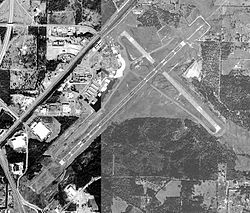
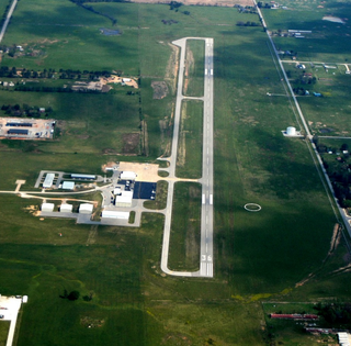
Boone County Airport is a public airport in Boone County, Arkansas. Also known as Boone County Regional Airport, it is four miles northwest of Harrison, Arkansas and serves the surrounding areas including Branson, Missouri. It is used for general aviation and sees one airline, a service subsidized by the federal government's Essential Air Service program at a cost of $2,251,207 per year.
Memorial Field Airport is located in City of Hot Springs, in Garland County, Arkansas, United States, 3 miles (4.8 km) southwest of Downtown Hot Springs. It serves nearby Hot Springs National Park. The airport is used for general aviation; airline flights are subsidized by the federal government's Essential Air Service program at a cost of $1,637,012.

Jonesboro Municipal Airport is located three miles east of Jonesboro, in Craighead County, Arkansas. It is mostly used for general aviation and is served by Southern Airways Express through the federally subsidized Essential Air Service program.

South Arkansas Regional Airport at Goodwin Field is nine miles west of El Dorado, in Union County, Arkansas, United States. It was served by SeaPort Airlines, a service subsidized by the federal government's Essential Air Service program at a cost of $1,977,153. SeaPort Airlines ceased operations on September 20, 2016.

Monroe Regional Airport is a public use airport in Ouachita Parish, Louisiana, United States. The airport is owned by the City of Monroe and is located within the city limits three nautical miles (6 km) east of its central business district.
Shreveport Regional Airport is a public use airport in Shreveport, Louisiana, United States. It is owned by the City of Shreveport and located four nautical miles (7 km) southwest of its central business district.
Dothan Regional Airport is a public airport in Dale County, Alabama, United States, seven miles northwest of Dothan, a city mostly in Houston County.

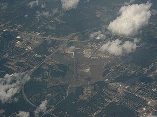
Montgomery Regional Airport is a civil-military airport seven miles southwest of Montgomery, the capital of Alabama. Owned by the Montgomery Airport Authority, it is used for general aviation and military aviation, and sees two airlines.
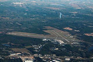
Fayetteville Regional Airport, also known as Grannis Field, is a public use airport in Cumberland County, North Carolina, United States. It is owned by the city of Fayetteville and located three nautical miles (6 km) south of its central business district.

Baxter County Airport, is a county-owned public-use airport located four nautical miles northwest of the central business district of Mountain Home, a city in Baxter County, Arkansas, United States. It was known as Baxter County Airport until 2005. It changed its name back to Baxter County Airport due to confusion with the close proximity of Ozark, Arkansas and Ozark, Missouri, both of which have airports. The airport used to be served by Lone Star Airlines, which operated services to Dallas-Fort Worth International in the mid-1990s.
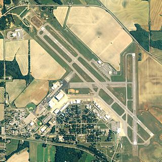
Delaware County Regional Airport is in Delaware County, Indiana three miles northwest of Muncie. Owned by the Delaware County Airport Authority, it was formerly Delaware County Airport and Johnson Field. The National Plan of Integrated Airport Systems for 2011–2015 categorized it as a general aviation facility.

Walnut Ridge Regional Airport is a city-owned public-use airport located four nautical miles (7 km) northeast of the central business district of Walnut Ridge, a city in Lawrence County, Arkansas, United States. According to the FAA's National Plan of Integrated Airport Systems for 2009–2013, its FAA airport category is general aviation.
Smith Field is a city-owned, public-use airport located three nautical miles northeast of the central business district of Siloam Springs, a city in Benton County, Arkansas, United States. According to the FAA's National Plan of Integrated Airport Systems for 2009–2013, it is categorized as a general aviation airport.
Rogers Executive Airport, also known as Carter Field, is a city-owned public-use airport located two nautical miles (3.7 km) north of the central business district of Rogers, a city in Benton County, Arkansas, United States. This airport is included in the FAA's National Plan of Integrated Airport Systems for 2021–2025, which categorized it as a general aviation facility.

Dexter B. Florence Memorial Field is a city-owned public-use airport located one nautical mile south of the central business district of Arkadelphia, a city in Clark County, Arkansas, United States.
Searcy Regional Airport is a city-owned public-use airport located three nautical miles south of the central business district of Searcy, in White County, Arkansas, United States.

Batesville Regional Airport is a public-use airport located three nautical miles south of the central business district of Batesville, in Independence County, Arkansas, United States. It is owned by the City of Batesville.
Richmond Municipal Airport is six miles southeast of Richmond near Boston, in Wayne County, Indiana. It is owned by the Richmond Board of Aviation Commissioners. The National Plan of Integrated Airport Systems for 2011–2015 called it a general aviation facility.