Newport Municipal Airport (Arkansas)

Last updated • 2 min readFrom Wikipedia, The Free Encyclopedia
Newport Municipal Airport
Newport Municipal Airport 2006 USGS.jpg
USGS aerial image, 2006
Summary
Airport typePublic
OwnerCity of Newport
Serves Newport, Arkansas
Elevation  AMSL 239 ft / 73 m
Coordinates 35°38′16″N91°10′35″W / 35.63778°N 91.17639°W / 35.63778; -91.17639
Map
USA Arkansas location map.svg
Airplane silhouette.svg
M19
Location of airport in Arkansas
Usa edcp location map.svg
Airplane silhouette.svg
M19
M19 (the United States)
Runways
Direction LengthSurface
ftm
4/225,0021,525Concrete
18/365,0021,525Concrete
Statistics (2009)
Aircraft operations10,000
Based aircraft25

Newport Municipal Airport( FAA LID : M19) is a city-owned public-use airport located five  nautical miles (6  mi, 9  km) northeast of the central business district of Newport, a city in Jackson County, Arkansas, United States. [1] It is included in the National Plan of Integrated Airport Systems for 2011–2015, which categorized it as a general aviation airport. [2]

Contents

History

Newport was chosen as a site for an Army Airfield during World War II through the encouragement of Congressman Wilbur D. Mills. The flat land already lent itself to airport usage as most trees had been cleared and the ground had been drained for farming. The project was announced in the middle of May 1942 and construction began almost immediately. 34 farm families were displaced from the main site, along with those living at the auxiliary sites. Construction was rapid given the emergency wartime conditions and within three months the post was to be in full operation. The airfield consisted of four concrete runways, 4907x150 (N/S), 5004x150 (NE/SW), 5000x150 (E/W), 5000x150 (NW/SE), plus associated taxiways, landing aids, and an extended length parking apron.

After the war, it reverted to civilian use.

Civil use

After the war's end, the Newport airfield was declared to be government surplus, and eventually, most of the main field was turned over to the City of Newport to be used as a civilian airport facility and industrial park. While many of the base's buildings were sold off, some were used by civilians who occupied much of the housing. The large hangar-type buildings were all gone by the early 1960s, and there are no longer any military buildings remaining at the airfield. All the auxiliary airfields were disposed of and none of the temporary structures built by the USAAF or USMC remain today. The few that survived the war were destroyed by a tornado in 1953. [3]

Several of the runways are still in use, and a new airport terminal was constructed in 1983. A number of industries are located at what is now the Newport Industrial Park. The Jackson County Learning Center has been located at the base since 1959. Some homes from the original residential area are still occupied. Also holding a place of prominence at the former airbase is Arkansas State University-Newport. [4] [5] [6] [7]

Facilities and aircraft

Newport Municipal Airport covers an area of 331 acres (134 ha) at an elevation of 239 feet (73 m) above mean sea level. It has two runways, 4/22 and 18/36, each with a concrete surface measuring 5,002 by 150 feet (1,525 x 46 m). [1]

For the 12-month period ending July 31, 2009, the airport had 10,000 aircraft operations, an average of 27 per day: 93% general aviation, 6% air taxi, and 1% military. At that time there were 25 aircraft based at this airport: 92% single-engine, and 8% multi-engine. [1]

See also

Related Research Articles

<span class="mw-page-title-main">Chico Regional Airport</span> Airport in Butte County, California

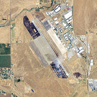
Chico Regional Airport, formerly known as Chico Municipal Airport, is four miles (6 km) north of Chico, in Butte County, California, United States. The airport covers 1,475 acres (6.0 km2), has two runways and one helipad. Its fixed-base operator, Northgate Aviation provides fuel, maintenance, flight training, and charter flights. Though an operational airport with that meets Federal Aviation Regulations Part 139 standards, the airport has not seen active commercial air service since SkyWest Airlines ended service to San Francisco at the end of 2014.

<span class="mw-page-title-main">Winter Haven's Gilbert Airport</span> Airport

Winter Haven's Gilbert Airport is a city-owned, public-use airport located three nautical miles (6 km) northwest of the central business district of Winter Haven, a city in Polk County, Florida, United States. It is owned by the City of Winter Haven. It is also known as Winter Haven Regional Airport or Gilbert Field. Jack Browns Seaplane Base is located adjacent to the airport, connected by a taxiway.

Bisbee Douglas International Airport is a county-owned airport 9 miles northwest of Douglas and 17 miles east of Bisbee, both in Cochise County, Arizona, United States, that was formerly known as Douglas Army Airfield. The FAA's National Plan of Integrated Airport Systems for 2009–2013 categorizes it as a general aviation facility.

<span class="mw-page-title-main">Cairns Army Airfield</span> Airport in Fort Novosel / Dale County, Alabama

Cairns Army Airfield is a military airport forming a part of Fort Novosel, in Dale County, Alabama, USA, and is owned by the United States Army. The airfield is south of the town of Daleville, which sits between it and the main post.

<span class="mw-page-title-main">Blythe Airport</span> Airport

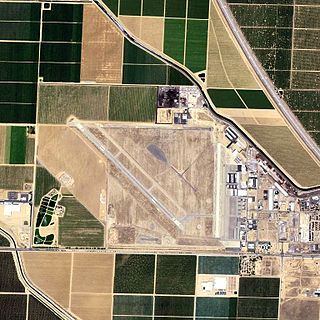
Blythe Airport is seven miles west of Blythe, in Riverside County, California, United States. The National Plan of Integrated Airport Systems for 2011–2015 categorized it as a general aviation facility.

<span class="mw-page-title-main">Shafter Airport</span> Airport in Kern County, California

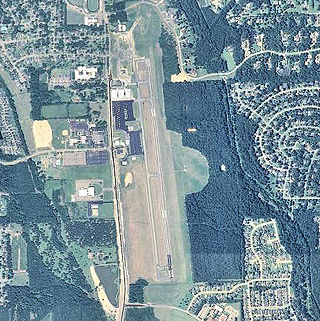
Shafter Airport, also known as Minter Field and formerly known as Air Corps Basic Flying School, is a public use airport located four nautical miles east of the central business district of Shafter and 14 miles northwest of Bakersfield, a city in Kern County, California, United States. Originally a World War II primary training facility for pilots, it is currently a public airport owned by the Minter Field Airport District. This airport is included in the National Plan of Integrated Airport Systems for 2011–2015, which categorized it as a general aviation facility.

<span class="mw-page-title-main">Grider Field</span> Airport in Jefferson County, Arkansas

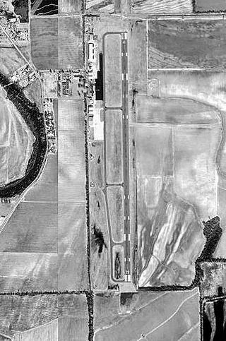
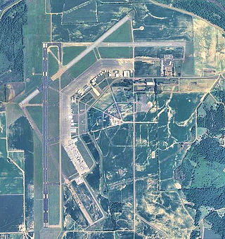
Grider Field, also known as Pine Bluff Regional Airport, is a municipal airport at Pine Bluff, Arkansas. It was established in 1941 as a U.S. Army Flight Training School operated by the Pine Bluff School of Aviation. After World War II, the city turned it into a commercial airport facility. It is a 850 acre facility consisting of a large terminal and restaurant, FAA weather monitoring equipment, private corporate hangars, fixed-base operators offering fuel and avionics services, a fire station, and aviation museum. It serves as the only ILS-equipped, jet capable airport in southeast Arkansas.

During World War II, Kansas was a major United States Army Air Forces (USAAF) training center for pilots and aircrews of USAAF fighters and bombers. Kansas was favored because it has excellent, year-round flying conditions. The sparsely populated land made ideal locations for gunnery, bombing, and training ranges.

<span class="mw-page-title-main">Avon Park Executive Airport</span> Airport in Highland County, Florida

Avon Park Executive Airport is a city-owned, public-use airport located two nautical miles (3.7 km) west of the central business district of Avon Park, a city in Highlands County, Florida, United States.

During World War II, the U.S. Army Air Forces (USAAF) established numerous airfields in Arkansas for training fighter and bomber pilots and aircrews.

<span class="mw-page-title-main">Eric Marcus Municipal Airport</span> Airport in Pima County, Arizona

Eric Marcus Municipal Airport is a county-owned, public-use airport in Pima County, Arizona, United States. It is located 5.75 miles north of the central business district of Ajo and is about 82 miles southwest of Phoenix. The airport was renamed on February 11, 2006; it was formerly known as Ajo Municipal Airport.

<span class="mw-page-title-main">Yucca Army Airfield</span> Former airfield in Mohave County, Arizona

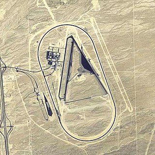
Yucca Army Airfield is a former military airfield located about 1 mile (1.6 km) west of Yucca, in Mohave County, Arizona, United States. It is on the east side of Interstate 40, 25 miles (40 km) south of Kingman. It is now used as a private facility owned by Fiat Chrysler Automobiles named Chrysler Arizona Proving Grounds.

<span class="mw-page-title-main">La Junta Municipal Airport</span> Airport in Otero County, Colorado

La Junta Municipal Airport is three miles north of La Junta, in Otero County, Colorado, United States. The National Plan of Integrated Airport Systems for 2011–2015 categorized it as a general aviation facility.

<span class="mw-page-title-main">Dalhart Army Air Base</span> Airport

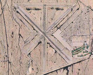
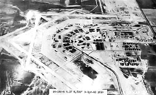
Dalhart Army Air Base is a former World War II military airfield complex near the city of Dalhart, Texas. It operated three training sites for the United States Army Air Forces from 1943 until 1945.

<span class="mw-page-title-main">Strother Army Airfield</span> WWII era US military installation

Strother Army Airfield was a World War II training base of the United States Army Air Forces Central Flying Training Command (CFTC), and later II Fighter Command. It is currently the city-owned Strother Field.

<span class="mw-page-title-main">Greenwood–Leflore Airport</span> Airport in Carroll County, Mississippi

Greenwood–Leflore Airport is a public airport located seven miles east of Greenwood, the county seat of Leflore County, Mississippi, United States. It is owned by the City of Greenwood and Leflore County, but is geographically located in Carroll County.

<span class="mw-page-title-main">Stuttgart Army Air Field (Arkansas)</span> Former airfield in Arkansas, United States

Stuttgart Army Airfield is a former World War II military airfield, located 7 miles north of Stuttgart, Arkansas. It operated as an advanced pilot training school for the United States Army Air Forces from 1942 until 1945.

<span class="mw-page-title-main">W. R. Byron Airport</span> Airport in Riverside County, California

W. R. Byron Airport is a privately owned, private use airport in Riverside County, California, United States. It is located four nautical miles northwest of the central business district of Blythe, California, within the city limits.

<span class="mw-page-title-main">Bruce Campbell Field</span> Airport in Madison County, Mississippi

Bruce Campbell Field is a city-owned public-use airport located two nautical miles (4 km) southeast of the central business district of Madison, a city in Madison County, Mississippi, United States. This airport is included in the National Plan of Integrated Airport Systems for 2011–2015, which categorized it as a general aviation airport.

<span class="mw-page-title-main">Eagle Pass Army Airfield</span> World War II US military installation

Eagle Pass Army Airfield is a former World War II military airfield complex. It is located 10.6 miles (17.1 km) north of Eagle Pass, Texas. It operated as a training base for the United States Army Air Forces from 1943 until 1945.

References

  1. 1 2 3 4 FAA Airport Form 5010 for M19 PDF . Federal Aviation Administration. Effective August 25, 2011.
  2. "2011–2015 NPIAS Report, Appendix A (PDF, 2.03 MB)" (PDF). National Plan of Integrated Airport Systems. Federal Aviation Administration. October 4, 2010.
  3. Shettle, M. L. Jr. (2001). United States Marine Corps Air Stations of World War II. Bowersville, Georgia: Schaertel Publishing Co. ISBN   0-9643388-2-3.
  4. PD-icon.svg This article incorporates public domain material from the Air Force Historical Research Agency
  5. Manning, Thomas A. (2005), History of Air Education and Training Command, 1942–2002. Office of History and Research, Headquarters, AETC, Randolph AFB, Texas OCLC   71006954 , 29991467
  6. Shaw, Frederick J. (2004), Locating Air Force Base Sites, History’s Legacy, Air Force History and Museums Program, United States Air Force, Washington DC. OCLC   57007862 , 1050653629
  7. Thole, Lou (1999), Forgotten Fields of America : World War II Bases and Training, Then and Now - Vol. 2. Publisher: Pictorial Histories Pub, ISBN   1-57510-051-7