National Register of Historic Places listings in Morrison County, Minnesota
Last updated
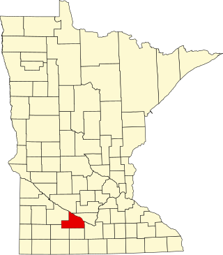
Location of Morrison County in Minnesota
This is a list of the National Register of Historic Places listings in Morrison County, Minnesota. It is intended to be a complete list of the properties and districts on the National Register of Historic Places in Morrison County, Minnesota, United States. The locations of National Register properties and districts for which the latitude and longitude coordinates are included below, may be seen in an online map.
There are 25 properties and districts listed on the National Register in the county, including one National Historic Landmark. A supplementary list includes two additional sites that were formerly on the National Register.
Homestead site occupied 1849–1865 by frontier missionary Frederick Ayer (1803–1867), where he established a parochial school for Ojibwe, mixed-blood, and white children.[5]
Minnesota's only unified road–rail bridge, built in 1930 as the key transportation connection for Camp Ripley, the state's first and most significant Minnesota National Guard reservation. Better known as the Camp Ripley Bridge.[7]
Little Falls' leading example of Neoclassical architecture, built c. 1900 and owned successively by notable local merchant Barney Burton and attorney/politician Christian Rosenmeier.[8] Now houses the Little Falls Convention and Visitors Bureau.
Long-used site at a key travel junction associated with the Dakota/Ojibwe territorial conflict and the early town of Old Crow Wing, whose abandonment in the 1880s uniquely preserves the succession of the Native American, fur trade, and logging eras. Extends into Cass and Crow Wing Counties.[10]
Remains of a temporary winter fort established in 1752 by French trader Joseph Marin de la Malgue; a key source of information on early European colonialism and exploration in the northwest.[11]
Park facilities significant as examples of New Deal federal work relief, state park development, and National Park Service rustic design, with six contributing properties built 1938–39.[16]
Downtown commercial district reflecting Little Falls' abrupt evolution from an agricultural trade center to a lumber and industrial powerhouse, with 32 contributing properties built 1887–1936.[18]
1911 parochial elementary school building enlarged in 1931, a local example of the nationally influential Catholic school system and anchor of the Belle Prairie community.[21]
Remains of a fort built by Zebulon Pike's first expedition, well preserved under a river impoundment; the only U.S. military post associated with the initial government exploration of northern Louisiana Territory.[23]
1891 office building, the only intact surviving structure of Frederick Weyerhaeuser's Minnesota lumber company (active 1890–1919), one of the state's largest and the major employer in Little Falls.[24]
Site of the 1847 house and trading post of William Whipple Warren (1825–1853) where he composed a seminal history of the Ojibwe, plus a homestead-era farm with an 1874 barn, encapsulating two periods of Minnesota frontier history.[28]
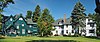
Adjoining 1898 houses of second-generation lumber magnates, symbolizing the Minnesota lumber industry and its domination by a few powerful individuals.[29] Now Linden Hill Historic Estate.[30]
This is a list of sites in Minnesota which are included in the National Register of Historic Places. There are more than 1,700 properties and historic districts listed on the NRHP; each of Minnesota's 87 counties has at least 2 listings. Twenty-two sites are also National Historic Landmarks.
This list is of the properties and historic districts which are designated on the National Register of Historic Places or that were formerly so designated, in Hennepin County, Minnesota; there are 190 entries as of April 2023. A significant number of these properties are a result of the establishment of Fort Snelling, the development of water power at Saint Anthony Falls, and the thriving city of Minneapolis that developed around the falls. Many historic sites outside the Minneapolis city limits are associated with pioneers who established missions, farms, and schools in areas that are now suburbs in that metropolitan area.
This is a list of the National Register of Historic Places listings in Goodhue County, Minnesota. It is intended to be a complete list of the properties and districts on the National Register of Historic Places in Goodhue County, Minnesota, United States. The locations of National Register properties and districts for which the latitude and longitude coordinates are included below, may be seen in an online map.
This is a list of the National Register of Historic Places listings in Saint Louis County, Minnesota. It is intended to be a complete list of the properties and districts on the National Register of Historic Places in Saint Louis County, Minnesota, United States. The locations of National Register properties and districts for which the latitude and longitude coordinates are included below, may be seen in an online map.
This is a list of the National Register of Historic Places listings in Stearns County, Minnesota. It is intended to be a complete list of the properties and districts on the National Register of Historic Places in Stearns County, Minnesota, United States. The locations of National Register properties and districts for which the latitude and longitude coordinates are included below, may be seen in an online map.
This is a list of the National Register of Historic Places listings in Brown County, Minnesota. It is intended to be a complete list of the properties and districts on the National Register of Historic Places in Brown County, Minnesota, United States. The locations of National Register properties and districts for which the latitude and longitude coordinates are included below, may be seen in an online map.
This is a list of the National Register of Historic Places listings in Crow Wing County, Minnesota. It is intended to be a complete list of the properties and districts on the National Register of Historic Places in Crow Wing County, Minnesota, United States. The locations of National Register properties and districts for which the latitude and longitude coordinates are included below, may be seen in an online map.
This is a list of the National Register of Historic Places listings in Nicollet County, Minnesota. It is intended to be a complete list of the properties and districts on the National Register of Historic Places in Nicollet County, Minnesota, United States. The locations of National Register properties and districts for which the latitude and longitude coordinates are included below, may be seen in an online map.
This is a list of the National Register of Historic Places listings in Otter Tail County, Minnesota. It is intended to be a complete list of the properties and districts on the National Register of Historic Places in Otter Tail County, Minnesota, United States. The locations of National Register properties and districts for which the latitude and longitude coordinates are included below, may be seen in an online map.
This is a list of the National Register of Historic Places listings in Winona County, Minnesota. It is intended to be a complete list of the properties and districts on the National Register of Historic Places in Winona County, Minnesota, United States. The locations of National Register properties and districts for which the latitude and longitude coordinates are included below, may be seen in an online map.
This is a list of the National Register of Historic Places listings in Fillmore County, Minnesota. It is intended to be a complete list of the properties and districts on the National Register of Historic Places in Fillmore County, Minnesota, United States. The locations of National Register properties and districts for which the latitude and longitude coordinates are included below, may be seen in an online map.
This is a list of the National Register of Historic Places listings in Washington County, Minnesota. It is intended to be a complete list of the properties and districts on the National Register of Historic Places in Washington County, Minnesota, United States. The locations of National Register properties and districts for which the latitude and longitude coordinates are included below, may be seen in an online map.
This is a list of the National Register of Historic Places listings in Wright County, Minnesota. It is intended to be a complete list of the properties and districts on the National Register of Historic Places in Wright County, Minnesota, United States. The locations of National Register properties and districts for which the latitude and longitude coordinates are included below, may be seen in an online map.
This is a list of the National Register of Historic Places listings in Cass County, Minnesota. It is intended to be a complete list of the properties and districts on the National Register of Historic Places in Cass County, Minnesota, United States. The locations of National Register properties and districts for which the latitude and longitude coordinates are included below, may be seen in an online map.
This is a list of the National Register of Historic Places listings in Douglas County, Minnesota. It is intended to be a complete list of the properties and districts on the National Register of Historic Places in Douglas County, Minnesota, United States. The locations of National Register properties and districts for which the latitude and longitude coordinates are included below, may be seen in an online map.
This is a list of the National Register of Historic Places listings in Todd County, Minnesota. It is intended to be a complete list of the properties and districts on the National Register of Historic Places in Todd County, Minnesota, United States. The locations of National Register properties and districts for which the latitude and longitude coordinates are included below, may be seen in an online map.
This is a list of the National Register of Historic Places listings in Mille Lacs County, Minnesota.
This is a list of the National Register of Historic Places listings in Beltrami County, Minnesota. This is intended to be a complete list of the properties and districts on the National Register of Historic Places in Beltrami County, Minnesota, United States. The locations of National Register properties and districts for which the latitude and longitude coordinates are included below, may be seen in an online map.
This is a list of the National Register of Historic Places listings in Mower County, Minnesota. It is intended to be a complete list of the properties and districts on the National Register of Historic Places in Mower County, Minnesota, United States. The locations of National Register properties and districts for which the latitude and longitude coordinates are included below, may be seen in an online map.
1 2 Numbers represent an alphabetical ordering by significant words. Various colorings, defined here, differentiate National Historic Landmarks and historic districts from other NRHP buildings, structures, sites or objects.
↑ The eight-digit number below each date is the number assigned to each location in the National Register Information System database, which can be viewed by clicking the number.
↑ Zeik, Susan; Douglas George (1973-04-13). "National Register of Historic Places Inventory – Nomination Form: Ayer Mission Site" (Document). National Park Service.
↑ Zeik, Susan; Douglas George (1973-04-11). "National Register of Historic Places Inventory – Nomination Form: Belle Prairie Village Site" (Document). National Park Service.
↑ Birk, Douglas A. (1984-02-15). "National Register of Historic Places Inventory—Nomination Form: Fort Duquesne" (Document). National Park Service.
↑ Location given at "Fort Ripley". Minnesota National Register Properties Database. Minnesota Historical Society. 2009. Retrieved 2014-01-11. NRIS lists site as "address restricted".
↑ Bredeson, Thomas (1970-08-11). "National Register of Historic Places Inventory – Nomination Form: Old Fort Ripley" (Document). National Park Service.
↑ George, Douglas (1973-05-01). "National Register of Historic Places Inventory – Nomination Form: Pelkey Lake Site" (Document). National Park Service.
↑ Birk, Douglas A. (1987-12-08). "National Register of Historic Places Inventory—Nomination Form: Zebulon Pike's 1805-06 Wintering Quarters" (Document). National Park Service.
This page is based on this Wikipedia article Text is available under the CC BY-SA 4.0 license; additional terms may apply. Images, videos and audio are available under their respective licenses.