Old Crow Wing, Minnesota

Last updated

The 1849 Beaulieu House, returned to the former townsite in 1988, overlooks the Mississippi River in Crow Wing State Park. OldCrowWingMN.jpg
The 1849 Beaulieu House, returned to the former townsite in 1988, overlooks the Mississippi River in Crow Wing State Park.

Old Crow Wing is a ghost town in Fort Ripley Township, Crow Wing County, Minnesota, United States, at the confluence of the Mississippi and Crow Wing rivers. Long occupied by the Ojibwe people, for over a century it was also the northernmost European-American settlement on the Mississippi.

Contents

In the 1850s and 1860s, Crow Wing was a county seat and one of the major population centers of Minnesota. At its peak it had an estimated 600–700 residents, about half of whom were Ojibwe. The town site, including one restored house, is preserved within Crow Wing State Park.

History

This area was inhabited by indigenous peoples for thousands of years before the first encounter with Europeans. At the confluence of the Crow Wing and Mississippi rivers, the site of the village of Old Crow Wing became a logical meeting place for the Dakota and later Ojibwe of Minnesota. [1]

Old Crow Wing's strategic location also made it attractive to European traders, the first of them recorded shortly after the close of the French and Indian War in 1763. The first trader of note to spend time at Old Crow Wing was James McGill in the winter of 1771–2, followed by many others. It also seems likely that two British army officers of the 54th Regiment of Foot visited the site in the early autumn of 1789, although the nature of this visit is disputed. [2]

The first European-American settler in Crow Wing was Allan Morrison, who opened a trading post in 1823. Around this time a lucrative, if technically illegal (because of post-War of 1812 restrictions on trading with Canadians) trade developed between Saint Paul, Minnesota, and the Red River Colony in Canada. Many of the fur trappers and traders were Métis, the biracial descendants of Ojibwe women and French, Scots and English men. Because the Ojibwe had a patrilineal system, in which children belonged to the father's clan and took their places in the tribe through it, the children of white fathers had no true place in the tribe. [3] Generally the trappers and their Ojibwe wives lived near the tribe, which would extend protection, but their children had to make their way outside it. Over generations, the Métis have developed as a distinct ethnic group in Canada, with characteristic cultural patterns, and they have won recognition of political status.

Since the Red River Trails crossed territory of the Dakota, the Ojibwe's traditional enemy, conflicts dogged the trade. A Métis attack on the Dakota in 1844 closed the primary route entirely. A Red River ox cart train on its return trip north traveled instead to the growing town of Crow Wing, forded the Mississippi, and blazed a new route that passed through much friendlier Ojibwe lands. This route became known as the Woods Trail. Although it was considerably harder going than the other Red River Trails, it was decidedly safer. [4] More traffic followed, particularly whenever relations with the Dakota were at their worst.

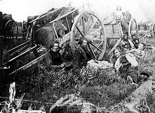
The village of Crow Wing became the principal supply station on the Woods Trail. Allan Morrison began operating a ferry across the Mississippi at the north end of town. In the 1840s other traders set up shop as well. This was the center of a multicultural community, with numerous mixed-race families, and associated Ojibwe, French Canadian and American families in the area.

Allan and his brother William Morrison, as well as the traders William Alexander Aitken, and Henry Mower Rice all went on to early prominence in the territory and state. Minnesota's Morrison, Aitkin, and Rice counties were named after them. Mower served as a state senator for five years and ran for governor in 1865. Clement Hudon Beaulieu, a Métis, also became a successful trader, running the American Fur Company's trading post.

The American William Whipple Warren was bilingual and worked as an interpreter for Rice. Also of Ojibwe descent, he interviewed Ojibwe elders and completed his classic History of the Ojibway People in 1853. (It was published by the Minnesota Historical Society in 1885.) Warren married Mathilda Aitken, daughter of the fur trader William and his Ojibwe wife. Warren was elected to the territorial legislature in 1850.

Several important Ojibwe leaders lived in Crow Wing, including Curly Head, Hole in the Day and his father, and Strong Ground. Henry Rice negotiated with them for logging rights to their land, and logging became a significant industry in Crow Wing.

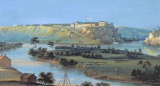
In 1848, the U.S. Army established Fort Ripley nearby. Reflecting success in the fur trade, in 1849 Clement Beaulieu had a house built in the popular Greek Revival style. Father Francis Xavier Pierz established a Catholic mission in Crow Wing in 1852, [5] later headed by Lovrenc Lavtižar. [6] An Episcopal mission was built in 1856, and a Lutheran church soon after.

Two events brought Crow Wing's heyday to a swift end. In 1868, the United States resettled the Ojibwe, including Clement and Elizabeth Beaulieu, to the White Earth Indian Reservation in northwestern Minnesota.

In 1871, the railroad magnate James J. Hill decided to route his Northern Pacific Railway over the Mississippi River at Brainerd, ten miles to the north and bypassing Crow Wing. A year later the county made Brainerd its seat of government, and businesses and population followed.

By 1880, most of Crow Wing's residents had moved on. Two of Beaulieu's nephews moved their uncle's former house to Morrison County, where it was inhabited continuously into the 1980s. After Larry and Joyce Moran of Little Falls donated the house to the Minnesota Department of Natural Resources, the house was moved back to its original location in 1988, now within Crow Wing State Park.

Related Research Articles

<span class="mw-page-title-main">Morrison County, Minnesota</span> County in Minnesota, United States

Morrison County is a county in the U.S. state of Minnesota. As of the 2020 census, the population was 34,010. Its county seat is Little Falls. Camp Ripley Military Reservation occupies a significant area in north-central Morrison County.

<span class="mw-page-title-main">Crow Wing County, Minnesota</span> County in Minnesota, United States

Crow Wing County is a county in the East Central part of the U.S. state of Minnesota. As of the 2020 census, the population was 66,123. Its county seat is Brainerd. The county was formed in 1857, and was organized in 1870.

<span class="mw-page-title-main">Henry Hastings Sibley</span> American politician and military leader (1811–1891)

Henry Hastings Sibley was a fur trader with the American Fur Company, the first U.S. Congressional representative for Minnesota Territory, the first governor of the state of Minnesota, and a U.S. military leader in the Dakota War of 1862 and a subsequent expedition into Dakota Territory in 1863.

<span class="mw-page-title-main">Henry M. Rice</span> American politician

Henry Mower Rice was a fur trader and an American politician prominent in the statehood of Minnesota.

<span class="mw-page-title-main">Crow Wing River</span> River in Minnesota, United States

The Crow Wing River is a 113-mile-long (182 km) tributary of the Mississippi River in Minnesota, United States. The river rises at an elevation of about 1391 feet in a chain of 11 lakes in southern Hubbard County, Minnesota, and flows generally south, then east, entering the Mississippi at Crow Wing State Park northwest of Little Falls, Minnesota. Its name is a loose translation from the Ojibwe language Gaagaagiwigwani-ziibi. A wing-shaped island at its mouth accounts for the river's name. Because of its many campsites and its undeveloped shores, the Crow Wing River is considered one of the state's best "wilderness" routes for canoeists; although it is shallow, it is nearly always deep enough for canoeing.

Mississippi River Band of Chippewa Indians or simply the Mississippi Chippewa, are a historical Ojibwa Band inhabiting the headwaters of the Mississippi River and its tributaries in present-day Minnesota.

<span class="mw-page-title-main">Crow Wing State Park</span> United States historic place

Crow Wing State Park is a state park of Minnesota, United States, at the confluence of the Mississippi and Crow Wing Rivers. The park interprets the site of Old Crow Wing, one of the most populous towns in Minnesota in the 1850s and 1860s. The entire park was added to the National Register of Historic Places in 1970. A section of the Red River Trails that passed through Old Crow Wing is also separately listed on the National Register.

<span class="mw-page-title-main">Francis Xavier Pierz</span> American-Slovenian writer and priest

Francis Xavier Pierz was a Roman Catholic priest and missionary to the Ottawa and Ojibwe Indians in present-day Michigan, Wisconsin, Ontario, and Minnesota. Because his letters convinced numerous Catholic German Americans to settle in Central Minnesota, he is referred to as the "Father of the Diocese of Saint Cloud."

<span class="mw-page-title-main">Minnesota State Highway 218</span> Highway in Minnesota

Minnesota State Highway 218 was a highway that originally ran from U.S. Route 218 in St. Paul to U.S. Route 210 in Brainerd. In 1935, it was extended south to Owatonna along the former route of U.S. 218. Around 1949, it was extended north of Brainerd to Merrifield.

<span class="mw-page-title-main">Pike Island</span> River island in Minnesota, United States

Pike Island is an island at the confluence of the Mississippi and Minnesota rivers in the southwestern-most part of Saint Paul in the U.S. state of Minnesota. The island is managed as part of Fort Snelling State Park and is within the Mississippi National River and Recreation Area. For centuries, Dakota people have considered the area of the island to be a sacred place where they moved with the seasons to find food and resources. The island is named after Zebulon Pike, who negotiated the United States government purchase of the area from Mdewakanton Sioux Indians in 1805.

<span class="mw-page-title-main">Red River Trails</span> Network of trails connecting the Red River Colony and Fort Garry in British North America

The Red River Trails were a network of ox cart routes connecting the Red River Colony and Fort Garry in British North America with the head of navigation on the Mississippi River in the United States. These trade routes ran from the location of present-day Winnipeg in the Canadian province of Manitoba across the Canada–United States border, and thence by a variety of routes through what is now the eastern part of North Dakota and western and central Minnesota to Mendota and Saint Paul, Minnesota on the Mississippi.

<span class="mw-page-title-main">Treaty of Old Crossing</span> 1863 and 1864 treaties between the United States and Chippewa

By the Treaty of Old Crossing (1863) and the Treaty of Old Crossing (1864), the Pembina and Red Lake bands of the Ojibwe, then known as Chippewa Indians, purportedly ceded to the United States all of their rights to the Red River Valley. On the Minnesota side, the ceded territory included all lands lying west of a line running generally southwest from the Lake of the Woods to Thief Lake, about 30 miles (48 km) west of Red Lake, and then angling southeast to the headwaters of the Wild Rice River near the low-lying divide separating the watershed of the Red River of the North from the watershed of the Mississippi River. On the North Dakota side, the ceded territory included all of the Red River Valley north of the Sheyenne River. The total land area, roughly 127 miles (204 km) wide east to west and 188 miles (303 km) long north to south, consisted of nearly 11,000,000 acres (45,000 km2) of rich prairie land and forests.

<span class="mw-page-title-main">William Whipple Warren</span> Historian, interpreter, and legislator in the Minnesota Territory

William Whipple Warren was a historian, interpreter, and legislator in the Minnesota Territory. The son of Lyman Marcus Warren, an American fur trader and Mary Cadotte, the Ojibwe-Metis daughter of fur trader Michel Cadotte, he was of Ojibwe and French descent. William lived in two cultures, because his father was white, he was not considered Ojibwe, but an Ojibwe "relative", because in the Ojibwe patrilineal culture, inheritance and property were passed through the paternal line. His mother was Ojibwe and he learned her culture from her family. He is the first historian of the Ojibwe people in the European tradition.

<span class="mw-page-title-main">Territorial era of Minnesota</span> Period in Minnesota history, 1803–1858

The territorial era of Minnesota lasted from the Louisiana Purchase in 1803 to Minnesota's achieving statehood in 1858. The Minnesota Territory itself was formed only in 1849 but the area had a rich history well before this. Though there was a long history of European presence in the area before 19th century, it was during the 19th century that the United States began to establish a firm presence in what would become Minnesota.

The Huntersville State Forest is a state forest located in Wadena County, Minnesota. Around half of the forest is managed by the Minnesota Department of Natural Resources, with the other half controlled privately.

William Alexander Aitken, also known as William Alexander Aitkin, was a fur trader with the Ojibwe in the Upper Mississippi region. He was at first affiliated with the American Fur Company, founded by John Jacob Astor, but after 1838 he set up as an independent trader, based in St. Louis, Missouri.

<span class="mw-page-title-main">Hole in the Day</span> Chippewa chief (1825–1868)

Hole-in-the-Day (1825–1868) was a prominent chief of the Mississippi band of Ojibwe/Chippewa in Minnesota. The native pronunciation has been written with different spellings due different speakers variance in their enunciation, such as Bagone-giizhig, Bagwunagijik, Bug-o-nay-ki-shig, Pugonakeshig or Puk-O-Nay-Keshig. Hole-in-the-Day has also been called Hole-in-the-Sky. The name refers to a dream in which the guardian spirit was seen through an opening in the clouds. It also refers to the Anishinaabek name for the constellation of the same name, also known as the Pleiades.

Réaume's Trading Post was a trading post established on the Leaf River in 1792 in what is now Wing River Township, Minnesota, United States. No visible traces remain at the site, which is on private property, but archaeological investigations have identified several features. It was listed on the National Register of Historic Places in 1974 for having state-level significance in the themes of commerce and historical archaeology. It was nominated for its role in and research potential on the opening of the fur trade in north-central Minnesota.

<span class="mw-page-title-main">Old Wadena Historic District</span> Historical archaeology sites in Wadena County, Minnesota, US

The Old Wadena Historic District is a concentration of historical archaeology sites now largely contained within Old Wadena County Park in Thomastown Township, Minnesota, United States. Features include the sites of four successive trading posts established in 1782, 1792, 1825, and 1856; the original townsite of Wadena on the Red River Trails; and the county's first farm. The town was later moved 3.5 miles (5.6 km) south to its present location. The historic district was listed on the National Register of Historic Places in 1973 for having state-level significance in the themes of agriculture, non-aboriginal archaeology, and transportation. It was nominated for its archaeological potential at the seminal site of Euro-American activity in Wadena County, Minnesota.

<span class="mw-page-title-main">William Morrison (trader)</span> Canadian fur trader and explorer (1785–1866)

William Morrison was a Canadian fur trader and explorer who established numerous trading posts throughout Minnesota and is claimed to have been the first white person to discover Lake Itasca in 1804.

References

  1. Warren, William W. (1885). History of the Ojibwe People. St. Paul, Minn.: Minnesota Historical Society Press. p. 263.
  2. Woodward, Morgan P. (2011). Redcoats on the Upper Mississippi: British Espionage and Diplomacy at Old Crow Wing. St. Cloud, Minn.: Woody Productions.
  3. "Ojibwe Culture" Archived 2015-06-23 at the Wayback Machine , Milwaukee Public Museum, accessed 10 December 2011
    • Gilman, Rhoda R.; Carolyn Gilman; Deborah M. Stultz (1979). The Red River Trails: Oxcart Routes Between St. Paul and the Selkirk Settlement, 1820–1870. St. Paul: Minnesota Historical Society Press. ISBN   0-87351-133-6. pp. 9-10
  4. Voigt, Robert J. (1989). Crow Wing and Father Pierz. St. Cloud, Minn.: Diocese of St. Cloud.
  5. Acta et Dicta, vol. 5. 1917. St. Paul, MN: Catholic Historical Society of St. Paul, p. 240.

46°16′38″N94°20′15″W / 46.27722°N 94.33750°W / 46.27722; -94.33750