Irondale Township, Crow Wing County, Minnesota

Last updated
Irondale Township
USA Minnesota location map.svg
Red pog.svg
Irondale Township
Location within the state of Minnesota
Coordinates: 46°28′15″N94°0′5″W / 46.47083°N 94.00139°W / 46.47083; -94.00139 Coordinates: 46°28′15″N94°0′5″W / 46.47083°N 94.00139°W / 46.47083; -94.00139
Country United States
State Minnesota
County Crow Wing
Area
  Total31.1 sq mi (80.5 km2)
  Land27.8 sq mi (72.1 km2)
  Water3.2 sq mi (8.4 km2)
Elevation
1,260 ft (384 m)
Population
 (2000)
  Total1,113
  Density40.0/sq mi (15.4/km2)
Time zone UTC-6 (Central (CST))
  Summer (DST) UTC-5 (CDT)
FIPS code 27-31202 [1]
GNIS feature ID0664554 [2]
Website Township website

Irondale Township is a township in Crow Wing County, Minnesota, United States. The population was 1,113 at the 2000 census.

Contents

Geography

According to the United States Census Bureau, the township has a total area of 31.1 square miles (81 km2), of which 27.8 square miles (72 km2) of it is land and 3.2 square miles (8.3 km2) of it (10.45%) is water.

Demographics

As of the census [1] of 2000, there were 1,113 people, 430 households, and 310 families residing in the township. The population density was 40.0 people per square mile (15.4/km2). There were 542 housing units at an average density of 19.5/sq mi (7.5/km2). The racial makeup of the township was 98.56% White, 0.27% African American, 0.27% Native American, 0.18% Asian, 0.18% from other races, and 0.54% from two or more races. Hispanic or Latino of any race were 0.27% of the population.

There were 430 households, out of which 32.3% had children under the age of 18 living with them, 64.2% were married couples living together, 4.4% had a female householder with no husband present, and 27.9% were non-families. 23.0% of all households were made up of individuals, and 11.9% had someone living alone who was 65 years of age or older. The average household size was 2.59 and the average family size was 3.07.

In the township the population was spread out, with 26.1% under the age of 18, 6.0% from 18 to 24, 24.8% from 25 to 44, 27.2% from 45 to 64, and 15.8% who were 65 years of age or older. The median age was 42 years. For every 100 females, there were 103.1 males. For every 100 females age 18 and over, there were 98.1 males.

The median income for a household in the township was $40,625, and the median income for a family was $46,477. Males had a median income of $32,500 versus $20,385 for females. The per capita income for the township was $17,968. About 1.7% of families and 4.0% of the population were below the poverty line, including 5.9% of those under age 18 and 2.3% of those age 65 or over.

Related Research Articles

Lee Township, Calhoun County, Michigan Township in Michigan, United States

Lee Township is a civil township of Calhoun County in the U.S. state of Michigan. It is part of the Battle Creek Metropolitan Statistical Area. The population was 1,213 at the 2010 census.

Brampton Township, Michigan Civil township in Michigan, United States

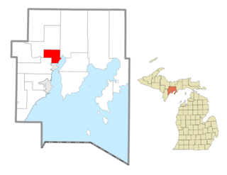
Brampton Township is a civil township of Delta County in the U.S. state of Michigan. As of the 2010 census, the township population was 1,050, down from 1,090 at the 2000 census.

Nahma Township, Michigan Civil township in Michigan, United States

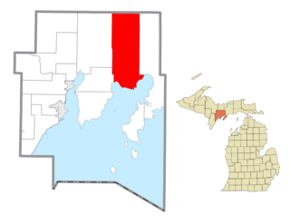
Nahma Township is a civil township of Delta County in the U.S. state of Michigan. The population was 495 at the 2010 census, slightly down from 499 at the 2000 census. Nahma was established in 1881 by the Bay De Noquet Lumber Company as the base for its upper Michigan lumbering operations.

White Oak Township, Michigan Township in Michigan, United States

White Oak Township is a civil township of Ingham County in the U.S. state of Michigan. The population was 1,177 at the 2000 census.

Emmett Township, St. Clair County, Michigan Civil township in Michigan, United States

Emmett Township is a civil township of St. Clair County in the U.S. state of Michigan. The population was 2,654 at the 2010 Census. The village of Emmett is located within the township. Emmett Township was set off from Clyde Township in 1850. It is named for Irish patriot Robert Emmet.

Hill Lake Township, Aitkin County, Minnesota Township in Minnesota, United States

Hill Lake Township is a township in Aitkin County, Minnesota, United States. The population was 430 as of the 2010 census.

Oakland Township, Freeborn County, Minnesota Township in Minnesota, United States

Oakland Township is a township in Freeborn County, Minnesota, United States. The population was 430 at the 2000 census.

Shell Rock Township, Freeborn County, Minnesota Township in Minnesota, United States

Shell Rock Township is a township in Freeborn County, Minnesota, United States. The population was 430 at the 2000 census.

Cherry Grove Township, Goodhue County, Minnesota Township in Minnesota, United States

Cherry Grove Township is a township in Goodhue County, Minnesota, United States. The population was 430 at the 2000 census.

Helga Township, Hubbard County, Minnesota Township in Minnesota, United States

Helga Township is a township in Hubbard County, Minnesota, United States. The population was 1,109 at the 2000 census.

Bangor Township, Pope County, Minnesota Township in Minnesota, United States

Bangor Township is a township in Pope County, Minnesota, United States. The population was 217 at the 2000 census.

Beaver Falls Township, Renville County, Minnesota Township in Minnesota, United States

Beaver Falls Township is a township in Renville County, Minnesota, United States. The population was 331 at the 2000 census.

Wing River Township, Wadena County, Minnesota Township in Minnesota, United States

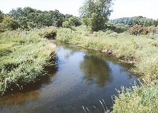
Wing River Township is a township in Wadena County, Minnesota, United States. The population was 430 at the 2000 census. It is named for the Wing River, which joins the Leaf River in the township.

Silver Creek Township, Wright County, Minnesota Township in Minnesota, United States

Silver Creek Township is a township in Wright County, Minnesota, United States. The population was 2,332 at the 2000 census.

West Taylor Township, Cambria County, Pennsylvania Township in Pennsylvania, United States

West Taylor Township is a township in Cambria County, Pennsylvania, United States. The population was 795 at the 2010 census. It is part of the Johnstown, Pennsylvania Metropolitan Statistical Area.

North Newton Township, Cumberland County, Pennsylvania Township in Pennsylvania, United States

North Newton Township is a township in Cumberland County, Pennsylvania, United States. The population was 2,430 at the 2010 census.

Highland Township, Elk County, Pennsylvania Township in Pennsylvania, United States

Highland Township is a township in Elk County, Pennsylvania, United States. The population was 492 at the 2010 census.

Morris Township, Greene County, Pennsylvania Township in Pennsylvania, United States

Morris Township is a township in Greene County, Pennsylvania, United States. The population was 818 at the 2010 census, down from 1,040 at the 2000 census.

Lackawannock Township, Mercer County, Pennsylvania Township in Pennsylvania, United States

Lackawannock Township is a township in Mercer County, Pennsylvania, United States. The population was 2,662 at the 2010 census. The origin of its name is disputed. One source contends that it was named for the Lackawanna River in eastern Pennsylvania, while another claims that it comes from the French word for "lake" (lac) and the name of a Native American chief (Wannock) who lived in the area.

Franklin Township, Susquehanna County, Pennsylvania Township in Pennsylvania, United States

Franklin Township is a township in Susquehanna County, Pennsylvania, United States. The population was 937 at the 2010 census. Salt Springs State Park, a Pennsylvania state park, is in Franklin Township.

References

  1. 1 2 "U.S. Census website". United States Census Bureau . Retrieved 2008-01-31.
  2. "US Board on Geographic Names". United States Geological Survey. 2007-10-25. Retrieved 2008-01-31.