Center Township, Crow Wing County, Minnesota

Last updated

Center Township
USA Minnesota location map.svg
Red pog.svg
Center Township
Location within the state of Minnesota
Usa edcp location map.svg
Red pog.svg
Center Township
Center Township (the United States)
Coordinates: 46°30′41″N94°6′36″W / 46.51139°N 94.11000°W / 46.51139; -94.11000
Country United States
State Minnesota
County Crow Wing
Area
  Total21.7 sq mi (56.2 km2)
  Land17.8 sq mi (46.0 km2)
  Water4.0 sq mi (10.2 km2)
Elevation
1,217 ft (371 m)
Population
 (2000)
  Total808
  Density45.5/sq mi (17.6/km2)
Time zone UTC-6 (Central (CST))
  Summer (DST) UTC-5 (CDT)
FIPS code 27-10567 [1]
GNIS feature ID0663771 [2]

Center Township is a township in Crow Wing County, Minnesota, United States. The population was 808 at the 2000 census.

Contents

Geography

According to the United States Census Bureau, the township has a total area of 21.7 square miles (56 km2), of which 17.8 square miles (46 km2) is land and 4.0 square miles (10 km2) (18.24%) is water.

Demographics

As of the census [1] of 2000, there were 808 people, 325 households, and 244 families residing in the township. The population density was 45.5 inhabitants per square mile (17.6/km2). There were 445 housing units at an average density of 25.1 per square mile (9.7/km2). The racial makeup of the township was 97.77% White, 0.25% Native American, 0.12% Asian, and 1.86% from two or more races. Hispanic or Latino of any race were 0.37% of the population.

There were 325 households, out of which 26.8% had children under the age of 18 living with them, 67.4% were married couples living together, 4.0% had a female householder with no husband present, and 24.9% were non-families. 21.8% of all households were made up of individuals, and 9.5% had someone living alone who was 65 years of age or older. The average household size was 2.47 and the average family size was 2.86.

In the township the population was spread out, with 21.2% under the age of 18, 7.2% from 18 to 24, 28.2% from 25 to 44, 27.2% from 45 to 64, and 16.2% who were 65 years of age or older. The median age was 41 years. For every 100 females, there were 103.5 males. For every 100 females age 18 and over, there were 104.8 males.

The median income for a household in the township was $40,000, and the median income for a family was $47,188. Males had a median income of $35,865 versus $19,219 for females. The per capita income for the township was $19,940. About 4.4% of families and 5.3% of the population were below the poverty line, including 5.2% of those under age 18 and 15.0% of those age 65 or over.

Related Research Articles

Woodland Township is a civil township of Barry County in the U.S. state of Michigan. The population was 2,047 at the 2010 census. The village of Woodland is located within the township.

<span class="mw-page-title-main">Maple Ridge Township, Delta County, Michigan</span> Civil township in Michigan, United States

Maple Ridge Township is a civil township of Delta County in the U.S. state of Michigan. The population was 766 at the 2010 census, down from 808 at the 2000 census.

<span class="mw-page-title-main">Waucedah Township, Michigan</span> Civil township in Michigan, United States

Waucedah Township is a civil township of Dickinson County in the U.S. state of Michigan. The population was 809 at the 2020 census.

<span class="mw-page-title-main">Bliss Township, Michigan</span> Civil township in Michigan, United States

Bliss Township is a civil township of Emmet County in the U.S. state of Michigan. As of the 2010 census, the township population was 620. It was named after Governor Aaron T. Bliss. Bliss Township is the location of Wilderness State Park and White Shoal Light.

<span class="mw-page-title-main">Elkton, Michigan</span> Village in Michigan, United States

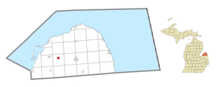
Elkton is a village in Huron County in the U.S. state of Michigan. The population was 796 at the 2020 census. The village is within Oliver Township, along the Pinnebog River. It was incorporated in 1897.

<span class="mw-page-title-main">Grant Township, Mason County, Michigan</span> Civil township in Michigan, United States

Grant Township is a civil township of Mason County in the U.S. state of Michigan. As of the 2020 census, the township population was 925.

<span class="mw-page-title-main">Thompson Township, Michigan</span> Civil township in Michigan, United States

Thompson Township is a civil township of Schoolcraft County in the U.S. state of Michigan. As of 2020, its population was 808.

Verona Township is a township in Faribault County, Minnesota, United States. The population was 391 at the 2000 census.

Albert Lea Township is a township in Freeborn County, Minnesota, United States. The population was 808 at the 2000 census.

Bancroft Township is a township in Freeborn County, Minnesota, United States. The population was 1,065 at the 2000 census.

Whited Township is a township in Kanabec County, Minnesota, United States. The population was 808 at the 2000 census.

Litchfield Township is a township in Meeker County, Minnesota, United States. The population was 808 at the 2000 census. The township includes most of the city of Litchfield, except for a small protrusion northeast into Forest City Township and another small one due east into Darwin Township.

Troy Township is a township in Renville County, Minnesota, United States. The population was 325 at the 2000 census.

Darnen Township is a township in Stevens County, Minnesota, United States. The population was 325 at the 2000 census.

<span class="mw-page-title-main">Brownsville Township, Fayette County, Pennsylvania</span> Township in Pennsylvania, United States

Brownsville Township is a township in Fayette County, Pennsylvania, United States. The population was 534 at the 2020 census, a decline from the figure of 683 tabulated in 2010. It is served by the Brownsville School District.

<span class="mw-page-title-main">Buffalo Township, Perry County, Pennsylvania</span> Township in Pennsylvania, United States

Buffalo Township is a township in Perry County, Pennsylvania, United States. The population was 1,222 at the 2020 census.

<span class="mw-page-title-main">Donaldson, Pennsylvania</span> CDP in Pennsylvania, United States

Donaldson is a census-designated place (CDP) in Frailey Township, Schuylkill County, Pennsylvania, United States. The population was 325 at the 2000 census.

<span class="mw-page-title-main">Franklin Township, Susquehanna County, Pennsylvania</span> Township in Pennsylvania, United States

Franklin Township is a township in Susquehanna County, Pennsylvania, United States. The population was 833 at the 2020 census. Salt Springs State Park, a Pennsylvania state park, is in Franklin Township.

<span class="mw-page-title-main">South Lancaster, Wisconsin</span> Town in Wisconsin, United States

South Lancaster is a town in Grant County, Wisconsin, United States. The population was 808 at the 2000 census.

<span class="mw-page-title-main">Selby Township, Bureau County, Illinois</span> Township in Illinois, United States

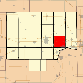
Selby Township is one of twenty-five townships in Bureau County, Illinois, USA. As of the 2020 census, its population was 2,152 and it contained 929 housing units.

References

  1. 1 2 "U.S. Census website". United States Census Bureau . Retrieved January 31, 2008.
  2. "US Board on Geographic Names". United States Geological Survey. October 25, 2007. Retrieved January 31, 2008.