Garrison Township, Crow Wing County, Minnesota

Last updated
Garrison Township
USA Minnesota location map.svg
Red pog.svg
Garrison Township
Location within the state of Minnesota
Usa edcp location map.svg
Red pog.svg
Garrison Township
Garrison Township (the United States)
Coordinates: 46°17′10″N93°51′7″W / 46.28611°N 93.85194°W / 46.28611; -93.85194 Coordinates: 46°17′10″N93°51′7″W / 46.28611°N 93.85194°W / 46.28611; -93.85194
Country United States
State Minnesota
County Crow Wing
Area
  Total35.4 sq mi (91.8 km2)
  Land29.3 sq mi (75.9 km2)
  Water6.1 sq mi (15.9 km2)
Elevation
1,296 ft (395 m)
Population
 (2000)
  Total796
  Density27.2/sq mi (10.5/km2)
Time zone UTC-6 (Central (CST))
  Summer (DST) UTC-5 (CDT)
ZIP code
56450
Area code 320
FIPS code 27-23210 [1]
GNIS feature ID0664249 [2]

Garrison Township is a township in Crow Wing County, Minnesota, United States. The population was 796 at the 2000 census. Within the township is the city of Garrison.

Contents

Garrison Township was named for Oscar E. Garrison, a surveyor who lived there. [3]

Geography

According to the United States Census Bureau, the township has a total area of 35.4 square miles (92 km2), of which 29.3 square miles (76 km2) is land and 6.1 square miles (16 km2) (17.30%) is water.

Demographics

As of the census [1] of 2000, there were 796 people, 355 households, and 246 families residing in the township. The population density was 27.2 inhabitants per square mile (10.5/km2). There were 781 housing units at an average density of 26.6 per square mile (10.3/km2). The racial makeup of the township was 97.49% White, 0.13% African American, 1.26% Native American, 0.38% from other races, and 0.75% from two or more races. Hispanic or Latino of any race were 0.38% of the population.

There were 355 households, out of which 18.3% had children under the age of 18 living with them, 62.0% were married couples living together, 4.5% had a female householder with no husband present, and 30.7% were non-families. 22.3% of all households were made up of individuals, and 7.3% had someone living alone who was 65 years of age or older. The average household size was 2.24 and the average family size was 2.61.

In the township the population was spread out, with 18.3% under the age of 18, 6.7% from 18 to 24, 20.2% from 25 to 44, 34.5% from 45 to 64, and 20.2% who were 65 years of age or older. The median age was 48 years. For every 100 females, there were 108.9 males. For every 100 females age 18 and over, there were 110.4 males.

The median income for a household in the township was $33,421, and the median income for a family was $34,821. Males had a median income of $31,635 versus $23,456 for females. The per capita income for the township was $19,004. About 5.4% of families and 7.8% of the population were below the poverty line, including 9.2% of those under age 18 and 2.9% of those age 65 or over.

Related Research Articles

Leavenworth Township is a township in Brown County, Minnesota, United States. The population was 336 as of the 2000 census. Leavenworth Township was organized in 1859.

<span class="mw-page-title-main">Garrison, Minnesota</span> City in Minnesota, United States

Garrison is a city in Crow Wing County, Minnesota, United States, along Mille Lacs Lake. The population was 210 at the 2010 census. It is part of the Brainerd Micropolitan Statistical Area. U.S. Highway 169 and Minnesota State Highway 18 are the main routes in the community.

Ravenna Township is a township in Dakota County, Minnesota, United States. The population was 2,336 at the 2010 census.

Lund Township is a township in Douglas County, Minnesota, United States. The population was 355 at the 2000 census.

Akeley Township is a township in Hubbard County, Minnesota, United States. The population was 481 at the 2000 census.

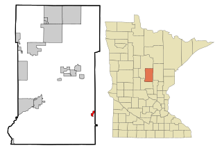
Richardson Township is a township in Morrison County, Minnesota, United States. The population was 485 at the 2000 census.

Ripley Township is a township in Morrison County, Minnesota, United States. The population was 692 at the 2000 census.

Rosing Township is a township in Morrison County, Minnesota, United States. The population was 135 at the 2000 census.

Scandia Valley Township is a township in Morrison County, Minnesota, United States. The population was 1,074 at the 2000 census. According to the U. S. Census Bureau it was merged with Rail Prairie Township on 31 December 2002. The larger township reported a population of 1,191 inhabitants in the 2010 census.

Swan River Township is a township in Morrison County, Minnesota, United States. The population was 755 at the 2000 census.

Reno Township is a township in Pope County, Minnesota, United States. The population was 355 at the 2000 census.

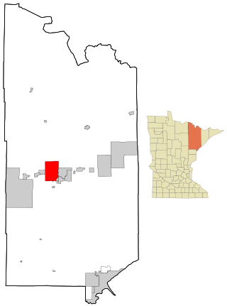
Industrial Township is a township in Saint Louis County, Minnesota, United States. The population was 800 at the 2010 census.

Leiding Township is a township in Saint Louis County, Minnesota, United States. The population was 400 at the 2010 census.

<span class="mw-page-title-main">Mountain Iron, Minnesota</span> City in Minnesota, United States

Mountain Iron is a city in Saint Louis County, Minnesota, United States, in the heart of the Mesabi Range. The population was 2,878 at the 2020 census.

Normanna Township is a township in Saint Louis County, Minnesota, United States. The population was 796 at the 2010 census.

Edison Township is a township in Swift County, Minnesota, United States. The population was 131 at the 2000 census.

May Township is a township in Washington County, Minnesota, United States. The population was 2,928 at the 2000 census.

Fremont Township is a township in Winona County, Minnesota, United States. The population was 355 at the 2010 census.

Victor Township is a township in Wright County, Minnesota, United States. The population was 1,069 at the 2000 census.

<span class="mw-page-title-main">South Manheim Township, Schuylkill County, Pennsylvania</span> Township in Pennsylvania, United States

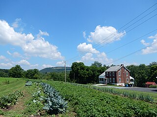
South Manheim Township is a township in Schuylkill County, Pennsylvania, United States. The population was 2,751 at the 2020 census. It was created in 1845 by dividing Manheim Township into South Manheim and North Manheim Townships.

References

  1. 1 2 "U.S. Census website". United States Census Bureau . Retrieved 2008-01-31.
  2. "US Board on Geographic Names". United States Geological Survey. 2007-10-25. Retrieved 2008-01-31.
  3. Warren Upham (1920). Minnesota Geographic Names: Their Origin and Historic Significance. Minnesota Historical Society. p.  158.