
Crow Wing County is a county in the U.S. state of Minnesota. As of the 2010 United States Census, the population was 62,500. Its county seat is Brainerd. The county was formed in 1857, and was organized in 1870.
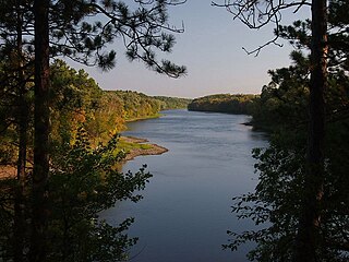
Crow Wing State Park is a state park of Minnesota, United States, at the confluence of the Mississippi and Crow Wing Rivers. The park interprets the site of Old Crow Wing, one of the most populous towns in Minnesota in the 1850s and 1860s. The entire park was added to the National Register of Historic Places in 1970. A section of the Red River Trails that passed through Old Crow Wing is also separately listed on the National Register.

Old Crow Wing is a ghost town in Fort Ripley Township, Crow Wing County, Minnesota, United States, at the confluence of the Mississippi and Crow Wing rivers. Long occupied by the Ojibwe people, for over a century it was also the northernmost European-American settlement on the Mississippi.

Merrifield is an unincorporated community and census-designated place (CDP) in Lake Edward Township, Crow Wing County, Minnesota, United States, near Brainerd. It is along Crow Wing County Road 3 near County Road 127. Its population was 140 as of the 2010 census.
Lake Hubert is an unincorporated community in Lake Edward Township, Crow Wing County, Minnesota, United States. Lake Hubert is 2 miles (3.2 km) southeast of Nisswa. It is along Crow Wing County Road 13 near County Road 137. Although it is unincorporated, Lake Hubert has the ZIP code 56459.
Crow Wing is an unincorporated community in Crow Wing Township, Crow Wing County, Minnesota, United States, south of Brainerd and Baxter. It is along State Highway 371 near 50th Avenue SW and 85th Street. Crow Wing is three miles northeast of Crow Wing State Park and the former town of Old Crow Wing.
Barrows is an unincorporated community in Crow Wing Township, Crow Wing County, Minnesota, United States, near Brainerd. It is located along Business Highway 371 near Depot Street, Barrows Avenue, and 70th Avenue.
Klondyke is an unincorporated community in Irondale Township, Crow Wing County, Minnesota, United States, near Crosby and Ironton.
Woodrow is an unincorporated community in Oak Lawn Township, Crow Wing County, Minnesota, United States, near Brainerd. It is along Woodrow Road near Dullum Road.
Wolford is an unincorporated community in Wolford Township, Crow Wing County, Minnesota, United States, near Crosby. It is along Crow Wing County Road 30 near River Road. State Highway 6 and County Road 11 are both nearby. Perry Lake Township is also in the immediate area.
Swanburg is an unincorporated community in Timothy Township, Crow Wing County, Minnesota, United States. It is along Crow Wing County Road 1 near Swanburg Road. Nearby places include Pine River, Manhattan Beach, and Crosslake.
St. Mathias is an unincorporated community in St. Mathias Township, Crow Wing County, Minnesota, United States. It is along Crow Wing County Road 121 near Hay Creek Road and Sleepy Hollow Road. Nearby places include Fort Ripley, Brainerd, and St. Mathias Park. Hay Creek and the Nokasippi River both flow nearby.
Pine Center is an unincorporated community in Roosevelt Township, Crow Wing County, Minnesota, United States. The community is located near the junction of Crow Wing County Roads 2 and 8. Nearby places include Brainerd, Garrison, Hillman, and Vineland.
Loerch is an unincorporated community in Oak Lawn Township, Crow Wing County, Minnesota, United States, near Brainerd. It is along Loerch Road near Dullum Road.
Little Pine is an unincorporated community in Little Pine Township, Crow Wing County, Minnesota, United States, near Emily. It is along Crow Wing County Road 1 near County Road 106. The Little Pine River flows nearby.
Legionville is an unincorporated community in Crow Wing County, Minnesota, United States, near Brainerd.
Iron Hub is an unincorporated community in Rabbit Lake Township, Crow Wing County, Minnesota, United States, near Deerwood and Aitkin. It is along Iron Hub Road near Crow Wing County Road 32 and State Highway 210.
Ideal Corners is an unincorporated community in Ideal Township, Crow Wing County, Minnesota, United States, near Pequot Lakes. It is along County Road 16 near County Road 39.
Crosby Beach is an unincorporated community in Irondale Township, Crow Wing County, Minnesota, United States, near Crosby.
Bay Lake is an unincorporated community in Bay Lake Township, Crow Wing County, Minnesota, United States, near Deerwood. It is along State Highway 6 near the junction with Crow Wing County Road 14.


