
Goodhue County is a county in the U.S. state of Minnesota. As of the 2020 census, the population was 47,582. Its county seat is Red Wing. Nearly all of Prairie Island Indian Community is within the county.

Crow Wing County is a county in the East Central part of the U.S. state of Minnesota. As of the 2020 census, the population was 66,123. Its county seat is Brainerd. The county was formed in 1857, and was organized in 1870.

Old Crow Wing is a ghost town in Fort Ripley Township, Crow Wing County, Minnesota, United States, at the confluence of the Mississippi and Crow Wing rivers. Long occupied by the Ojibwe people, for over a century it was also the northernmost European-American settlement on the Mississippi.

The Long Prairie River is a tributary of the Crow Wing River, 96 miles (154 km) long, in central Minnesota in the United States. Via the Crow Wing River, it is part of the watershed of the Mississippi River, draining an area of 892 square miles (2,310 km2) in a generally rural region.
The Fish Hook River, also spelled Fishhook River, is a tributary of the Shell River, 9 miles (14 km) long, in north-central Minnesota in the United States. The river's source, Fish Hook Lake, collects short tributaries known as the Portage River and the Potato River. Via the Shell and Crow Wing rivers, the Fish Hook River is part of the watershed of the Mississippi River. The river flows for its entire length in southwestern Hubbard County; its watershed extends into northeastern Becker County.

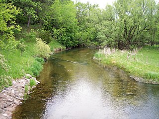
Hay Creek is a small trout stream in southeastern Minnesota. It has its headwaters west of Goodhue and empties into the Mississippi River just to the north of Red Wing. It runs 25.1 miles (40.4 km). Hay Creek was named for the hay meadows near its banks. A railroad once ran along Hay Creek from the claybanks near Goodhue to the pottery and stoneware factories in Red Wing, which also made use of the water from the creek. The railroad was torn up in 1937, but traces such as trestle pilings remain.
Ryan is an unincorporated community in Belle Creek Township, Goodhue County, Minnesota, United States.
Belvidere Mills is an unincorporated community in Belvidere Township, Goodhue County, Minnesota, United States.
Lake Hubert is an unincorporated community in Lake Edward Township, Crow Wing County, Minnesota, United States. Lake Hubert is 2 miles (3.2 km) southeast of Nisswa. It is along Crow Wing County Road 13 near County Road 137. Lake Hubert has the ZIP code 56459.
Cloverton is an unincorporated community in New Dosey Township, Pine County, Minnesota, United States.
Pomroy is an unincorporated community in Pomroy Township, Itasca County, Minnesota, United States.
Kingsdale is an unincorporated community in New Dosey Township, Pine County, Minnesota, United States.
Hay Creek is an unincorporated community in Hay Creek Township, Goodhue County, Minnesota, United States.
Wacouta is an unincorporated community in Wacouta Township, Goodhue County, Minnesota, United States.
Claybank is an unincorporated community in Goodhue Township, Goodhue County, Minnesota, United States.
Wolford is an unincorporated community in Wolford Township, Crow Wing County, Minnesota, United States, near Crosby. It is along Crow Wing County Road 30 near River Road. State Highway 6 and County Road 11 are both nearby. Perry Lake Township is also in the immediate area.
Swanburg is an unincorporated community in Timothy Township, Crow Wing County, Minnesota, United States. It is along Crow Wing County Road 1 near Swanburg Road. Nearby places include Pine River, Manhattan Beach, and Crosslake.
Pine Center is an unincorporated community in Roosevelt Township, Crow Wing County, Minnesota, United States. The community is located near the junction of Crow Wing County Roads 2 and 8. Nearby places include Brainerd, Garrison, Hillman, and Vineland.
Little Pine is an unincorporated community in Little Pine Township, Crow Wing County, Minnesota, United States, near Emily. It is along Crow Wing County Road 1 near County Road 106. The Little Pine River flows nearby.


