
Wadena County is a county in the East Central part of the U.S. state of Minnesota. As of the 2020 United States Census, the population was 14,065. Its county seat is Wadena.

Crow Wing County is a county in the East Central part of the U.S. state of Minnesota. As of the 2020 United States Census, the population was 66,123. Its county seat is Brainerd. The county was formed in 1857, and was organized in 1870.

Cass County is a county in the central part of the U.S. state of Minnesota. As of the 2020 United States Census, the population was 30,066. Its county seat is Walker. The county was formed in 1851, and was organized in 1897.

Farm Island Township is a township in Aitkin County, Minnesota, United States. The population was 1,099 as of the 2010 census.

Hazelton Township is a township in Aitkin County, Minnesota, United States. The population was 844 as of the 2010 census.
Barclay Township is a township in Cass County, Minnesota, United States. As of the 2000 census, its population was 516. Barclay Township was named for an early settler.
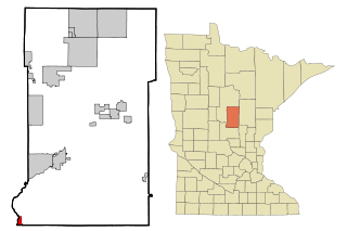
Brainerd is a city in Crow Wing County, Minnesota, United States. Its population was 13,592 as of the 2010 census. It is the county seat of Crow Wing County, and is one of northern Minnesota's largest cities. Brainerd straddles the Mississippi River several miles upstream from its confluence with the Crow Wing River, having been founded as a site for a railroad crossing above the confluence. Brainerd is the principal city of the Brainerd Micropolitan Area, a micropolitan area covering Cass and Crow Wing counties and with a combined population of 91,067 as of the 2010 census.

Emily is a city in Crow Wing County, Minnesota, United States. The population was 813 at the 2010 census. It is part of the Brainerd Micropolitan Statistical Area.
Fort Ripley is a city in Crow Wing County, Minnesota, United States, near the confluence of the Mississippi and Nokasippi Rivers. The population was 69 at the 2010 census. It is part of the Brainerd Micropolitan Statistical Area.

Jenkins is a city in Crow Wing County, Minnesota, United States. The population was 430 at the 2010 census. It is part of the Brainerd Micropolitan Statistical Area.
Mille Lacs Indian Reservation is the popular name for the land-base for the Mille Lacs Band of Ojibwe in Central Minnesota, about 100 miles (160 km) north of Minneapolis-St. Paul. The contemporary Mille Lacs Band reservation has significant land holdings in Mille Lacs, Pine, Aitkin and Crow Wing counties, as well as other land holdings in Kanabec, Morrison, and Otter Tail Counties. Mille Lacs Indian Reservation is also the name of a formal Indian reservation established in 1855. It is one of the two formal reservations on which the contemporary Mille Lacs Band retains land holdings. The contemporary Mille Lacs band includes several aboriginal Ojibwe bands and villages, whose members reside in communities throughout central Minnesota.

The Crow River is a tributary of the Mississippi River in south-central Minnesota in the United States. It drains a watershed of 2,756 square miles (7,140 km2).

The Long Prairie River is a tributary of the Crow Wing River, 96 miles (154 km) long, in central Minnesota in the United States. Via the Crow Wing River, it is part of the watershed of the Mississippi River, draining an area of 892 square miles (2,310 km2) in a generally rural region.
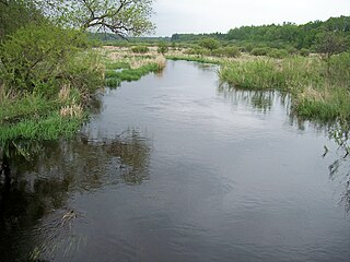
The Shell River is a 47.8-mile-long (76.9 km) tributary of the Crow Wing River in north-central Minnesota in the United States. Via the Crow Wing River, it is part of the watershed of the Mississippi River, draining a rural region.

The Straight River is a tributary of the Fish Hook River, 23 miles (37 km) long, in north-central Minnesota in the United States. Via the Fish Hook, Shell, and Crow Wing Rivers, it is part of the watershed of the Mississippi River, draining an area of approximately 60 square miles (160 km2) in a rural region. The river is known as one of Minnesota's best trout fishing streams.
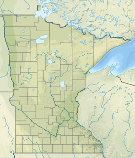
The Kettle River, also known as Kettle Creek, is a tributary of the Blueberry River, 17 miles (28 km) long, in north-central Minnesota in the United States. Via the Blueberry, Shell, and Crow Wing Rivers, it is part of the watershed of the Mississippi River, draining a rural area.

Manganese is a ghost town and former mining community in the U.S. state of Minnesota that was inhabited between 1912 and 1960. It was built in Crow Wing County on the Cuyuna Iron Range in sections 23 and 28 of Wolford Township, about 2 miles (3 km) north of Trommald, Minnesota. After its formal dissolution, Manganese was absorbed by Wolford Township; the former town site is located between Coles Lake and Flynn Lake. First appearing in the U.S. Census of 1920 with an already dwindling population of 183, the village was abandoned by 1960.
Lake Hubert is an unincorporated community in Lake Edward Township, Crow Wing County, Minnesota, United States. Lake Hubert is 2 miles (3.2 km) southeast of Nisswa. It is along Crow Wing County Road 13 near County Road 137. Lake Hubert has the ZIP code 56459.
Crow Wing is an unincorporated community in Crow Wing Township, Crow Wing County, Minnesota, United States, south of Brainerd and Baxter. It is along State Highway 371 near 50th Avenue SW and 85th Street. Crow Wing is three miles northeast of Crow Wing State Park and the former town of Old Crow Wing.
Klondyke is an unincorporated community in Irondale Township, Crow Wing County, Minnesota, United States. The community lies just south of County Route 12 and on the north shore of Lookout Lake. It lies approximately three miles south of Crosby and Ironton.


