Pierz, Minnesota

Last updated

Pierz, Minnesota
Pierz Aerial.jpg
Aerial view of Pierz, note St. Joseph's Church near the center
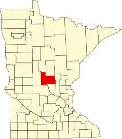
Morrison County Minnesota Incorporated and Unincorporated areas Pierz Highlighted.svg
Location in Morrison County and the state of Minnesota
Coordinates: 45°58′38″N94°06′03″W / 45.97722°N 94.10083°W / 45.97722; -94.10083
Country United States
State Minnesota
County Morrison
Founded1869
Area
[1]
  Total1.38 sq mi (3.57 km2)
  Land1.38 sq mi (3.57 km2)
  Water0.00 sq mi (0.00 km2)
Elevation
[2]
1,175 ft (358 m)
Population
[3]
  Total1,418
  Density1,028.28/sq mi (397.04/km2)
Time zone UTC-6 (Central (CST))
  Summer (DST) UTC-5 (CDT)
ZIP code
56364
Area code 320
FIPS code 27-50776 [4]
GNIS feature ID2396202 [2]
Website www.pierzmn.org

Pierz is a city in Morrison County, Minnesota, United States. The population was 1,418 at the 2020 census. [5]

Contents

History

Pierz was named for Father Francis Xavier Pierz (Slovene : Franc Pirc), a Slovenian Roman Catholic priest who came to Minnesota in the early 1850s as a missionary to the native Ojibwe people. [6] The town was incorporated on January 12, 1892, under the name "Rich Prairie", but on August 15, 1894, the residents voted to change the name to Pierz in F. X. Pierz's honor. [7]

Geography

Pierz is in eastern Morrison County. It is bordered to the south, east, and west by Pierz Township, also to the south by the city of Genola, and to the north by Buh Township. Minnesota State Highways 25 and 27 are the main routes in the city. MN 25 leads north 28 miles (45 km) to Brainerd and south 30 miles (48 km) to Foley, while MN 27 leads west 13 miles (21 km) to Little Falls, the Morrison county seat, and east-northeast 26 miles (42 km) to Onamia. Highways 25 and 27 leave Pierz together to the north, splitting 3 miles (5 km) north of town.

According to the U.S. Census Bureau, the city of Pierz has an area of 1.38 square miles (3.57 km2), all of it recorded as land. [1] The Skunk River passes through the southeast part of the city, flowing south and then west to join the Platte River, a south-flowing tributary of the Mississippi.

Demographics

Historical population
CensusPop.Note
1900 358
1910 54552.2%
1920 62414.5%
1930 6341.6%
1940 71412.6%
1950 85619.9%
1960 816−4.7%
1970 8939.4%
1980 1,01814.0%
1990 1,014−0.4%
2000 1,27725.9%
2010 1,3939.1%
2020 1,4181.8%
U.S. Decennial Census

2010 census

As of the census [8] of 2010, there were 1,393 people, 585 households, and 339 families living in the city. The population density was 1,031.9 inhabitants per square mile (398.4/km2). There were 605 housing units at an average density of 448.1 per square mile (173.0/km2). The racial makeup of the city was 98.6% White, 0.1% Native American, 0.2% Asian, 0.1% from other races, and 0.9% from two or more races. Hispanic or Latino of any race were 0.6% of the population.

There were 585 households, of which 29.4% had children under the age of 18 living with them, 42.2% were married couples living together, 11.8% had a female householder with no husband present, 3.9% had a male householder with no wife present, and 42.1% were non-families. 37.8% of all households were made up of individuals, and 25.7% had someone living alone who was 65 years of age or older. The average household size was 2.23 and the average family size was 2.94.

The median age in the city was 42.5 years. 24.5% of residents were under the age of 18; 7.1% were between the ages of 18 and 24; 21.2% were from 25 to 44; 19.8% were from 45 to 64; and 27.3% were 65 years of age or older. The gender makeup of the city was 41.3% male and 58.7% female.

2000 census

As of the census [4] of 2000, there were 1,277 people, 512 households, and 321 families living in the city. The population density was 945.8 inhabitants per square mile (365.2/km2). There were 522 housing units at an average density of 386.6 per square mile (149.3/km2). The racial makeup of the city was 98.67% White, 0.39% Native American, and 0.94% from two or more races. Hispanic or Latino of any race were 0.08% of the population.

There were 512 households, out of which 28.7% had children under the age of 18 living with them, 48.8% were married couples living together, 11.9% had a female householder with no husband present, and 37.3% were non-families. 33.0% of all households were made up of individuals, and 22.5% had someone living alone who was 65 years of age or older. The average household size was 2.29 and the average family size was 2.91.

In the city, the population was spread out, with 23.6% under the age of 18, 8.2% from 18 to 24, 22.9% from 25 to 44, 15.2% from 45 to 64, and 30.1% who were 65 years of age or older. The median age was 41 years. For every 100 females, there were 79.4 males. For every 100 females age 18 and over, there were 72.1 males.

The median income for a household in the city was $27,292, and the median income for a family was $34,167. Males had a median income of $29,107 versus $21,250 for females. The per capita income for the city was $14,638. About 6.0% of families and 13.6% of the population were below the poverty line, including 12.7% of those under age 18 and 20.8% of those age 65 or over.

Arts and culture

St Joseph's Church viewed from the west, 2013. St Joseph's Church.jpg
St Joseph's Church viewed from the west, 2013.

Every year Pierz celebrates Oktoberfest during the last weekend in August. There is a medallion search with daily clues; the winner gets $500 in "Pierz Bucks" from local businesses to spend in town. There is also a parade and festival at the city park plus other events, including live Oktoberfest music and games for children.

In the summer, Pierz hosts the Commercial Club's Rock, Roll, & Stroll event. It takes place on Main Street on the first Thursday of June, July, August, and September. During the R.R.S. classic cars roll-in to Pierz to park. These cars are works of art and are admired by many. Car owners, admirers, and pedestrians can find local food stands, business specials, and entertainment throughout town. The Pierz Commercial Club sponsors the event and provides prizes for classic car owners. In 2015, the prizes totaled over $1,000.

Pierz is home to Independent School District 484, where close to 1,200 students are served in grades preK-12. Students are offered a wide variety of outside activities including sports and clubs. The 2017 football season, led by coach Leo Pohlkamp, won the state title.

Notable people

Related Research Articles

<span class="mw-page-title-main">Kelliher, Minnesota</span> Town in Minnesota, United States

Kelliher is a city in Beltrami County, Minnesota, United States. The population was 258 at the 2020 census. Minnesota State Highway 72 is the primary route through Kelliher.

<span class="mw-page-title-main">St. Clair, Minnesota</span> City in Minnesota, United States

St. Clair or Saint Clair is a city in Blue Earth County, Minnesota, United States, located along the Le Sueur River. The population was 750 at the 2020 census. It is part of the Mankato-North Mankato Metropolitan Statistical Area.

<span class="mw-page-title-main">Pillager, Minnesota</span> City in Minnesota, United States

Pillager is a city in Cass County, Minnesota, United States. Its population was 507 at the 2020 census. It is part of the Brainerd Micropolitan Statistical Area.

<span class="mw-page-title-main">Georgetown, Minnesota</span> City in Minnesota, United States

Georgetown is a city in Clay County, Minnesota, United States, along the Buffalo River near its confluence with the Red River of the North. The population was 86 at the 2020 census.

<span class="mw-page-title-main">Evansville, Minnesota</span> City in Minnesota, United States

Evansville is a city in Douglas County, Minnesota, United States. The population was 603 at the 2020 census.

<span class="mw-page-title-main">Nelson, Minnesota</span> City in Minnesota, United States

Nelson is a city in Douglas County, Minnesota, United States. The population was 182 at the 2020 census.

<span class="mw-page-title-main">Canton, Minnesota</span> City in Minnesota, United States

Canton is a city in Fillmore County, Minnesota, United States. The population was 346 at the 2010 census.

<span class="mw-page-title-main">Lancaster, Minnesota</span> City in Minnesota, United States

Lancaster is a city in Kittson County, Minnesota, United States. As of the 2020 census, the city population was 364.

<span class="mw-page-title-main">Middle River, Minnesota</span> City in Minnesota, United States

Middle River is a city in Marshall County, Minnesota, United States, along the Middle River, from which the city took its name. The population was 304 at the 2020 census.

<span class="mw-page-title-main">Buckman, Minnesota</span> City in ohio United States

Buckman is a city in Morrison County, Minnesota, United States. The population was 307 at the 2020 Census.

<span class="mw-page-title-main">Harding, Minnesota</span> Town in Minnesota, United States

Harding is a city in Morrison County, Minnesota, United States. The population was 123 at the 2020 census. There’s also a parade in winter called the Harding Horse parade and have Harding days around the Fourth of July, which attracts a few thousand people especially The rodeo

<span class="mw-page-title-main">Hillman, Minnesota</span> City in Minnesota, United States

Hillman is a city in Morrison County, Minnesota, United States. The population was 23 at the 2020 census.

<span class="mw-page-title-main">Lastrup, Minnesota</span> City in Minnesota, United States

Lastrup is a city in Morrison County, Minnesota, United States. The population was 120 at the 2020 census.

Pierz Township is a township in Morrison County, Minnesota, United States. The population was 513 at the 2000 census.

<span class="mw-page-title-main">Urbank, Minnesota</span> City in Minnesota, United States

Urbank is a city in Otter Tail County, Minnesota, United States. The population was 52 at the 2020 census.

<span class="mw-page-title-main">McKinley, St. Louis County, Minnesota</span> City in Minnesota, United States

McKinley is a city in Saint Louis County, Minnesota, United States; located within the Iron Range region of Minnesota. The population was 103 at the 2020 census.

<span class="mw-page-title-main">Winton, Minnesota</span> City in Minnesota, United States

Winton is a city in Saint Louis County, Minnesota, United States. The population was 169 at the 2020 census. The city is home to a small hydroelectric dam on the edge of Garden Lake, one of 11 stations owned by Minnesota Power.

<span class="mw-page-title-main">Darfur, Minnesota</span> City in the United States

Darfur is a city in Watonwan County, Minnesota, United States. The population was 108 at the 2010 census.

<span class="mw-page-title-main">Campbell, Minnesota</span> City in Minnesota, United States

Campbell is a city in Wilkin County, Minnesota, United States. The population was 164 at the 2020 census. It is part of the Wahpeton, ND-MN Micropolitan Statistical Area.

<span class="mw-page-title-main">Genola, Minnesota</span> City in Minnesota, United States

Genola is a city in Morrison County, Minnesota, United States. The population was 70 at the 2020 census.

References

  1. 1 2 "2023 U.S. Gazetteer Files: Minnesota". United States Census Bureau. Retrieved February 1, 2024.
  2. 1 2 U.S. Geological Survey Geographic Names Information System: Pierz, Minnesota
  3. "P1. Race – Pierz city, Minnesota: 2020 DEC Redistricting Data (PL 94-171)". U.S. Census Bureau. Retrieved February 1, 2024.
  4. 1 2 "U.S. Census website". United States Census Bureau . Retrieved January 31, 2008.
  5. "U.S. Census Bureau: Pierz city, Minnesota". www.census.gov. United States Census Bureau. Retrieved May 5, 2022.
  6. Upham, Warren (1920). Minnesota Geographic Names: Their Origin and Historic Significance. Minnesota Historical Society. p.  354.
  7. "Welcome to Pierz, Minnesota". www.pierzmn.org.
  8. "U.S. Census website". United States Census Bureau . Retrieved November 13, 2012.
  9. "Wells Fargo CEO John Stumpf is out". October 12, 2016.