Motley Township, Morrison County, Minnesota

Last updated
Motley Township, Minnesota
USA Minnesota location map.svg
Red pog.svg
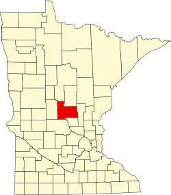
Motley Township, Minnesota
Location within the state of Minnesota
Usa edcp location map.svg
Red pog.svg
Motley Township, Minnesota
Motley Township, Minnesota (the United States)
Coordinates: 46°18′22″N94°35′29″W / 46.30611°N 94.59139°W / 46.30611; -94.59139 Coordinates: 46°18′22″N94°35′29″W / 46.30611°N 94.59139°W / 46.30611; -94.59139
Country United States
State Minnesota
County Morrison
Government
  MayorJayde Jordahl
Area
  Total15.9 sq mi (41.2 km2)
  Land15.3 sq mi (39.6 km2)
  Water0.6 sq mi (1.5 km2)
Elevation
1,227 ft (374 m)
Population
 (2000)
  Total205
  Density13.4/sq mi (5.2/km2)
Time zone UTC-6 (Central (CST))
  Summer (DST) UTC-5 (CDT)
ZIP code
56466
Area code 218
FIPS code 27-44440 [1]
GNIS feature ID0665047 [2]

Motley Township is a township in Morrison County, Minnesota, United States. The population was 205 at the 2000 census.

Contents

Motley Township was organized in 1879, and named after Motley, Minnesota. [3]

Geography

According to the United States Census Bureau, the township has a total area of 15.9 square miles (41.2 km2), of which 15.3 square miles (39.7 km2) is land and 0.6 square mile (1.5 km2) (3.65%) is water. The northern boundary of the township is defined by the Crow Wing River; the Long Prairie River, a tributary of the Crow Wing, flows through the northwestern part of the township. [4]

Demographics

As of the census [1] of 2000, there were 205 people, 79 households, and 59 families residing in the township. The population density was 13.4 people per square mile (5.2/km2). There were 98 housing units at an average density of 6.4/sq mi (2.5/km2). The racial makeup of the township was 100.00% White.

There were 79 households, out of which 30.4% had children under the age of 18 living with them, 63.3% were married couples living together, 6.3% had a female householder with no husband present, and 24.1% were non-families. 19.0% of all households were made up of individuals, and 10.1% had someone living alone who was 65 years of age or older. The average household size was 2.48 and the average family size was 2.75.

In the township the population was spread out, with 22.4% under the age of 18, 6.3% from 18 to 24, 23.9% from 25 to 44, 27.8% from 45 to 64, and 19.5% who were 65 years of age or older. The median age was 44 years. For every 100 females, there were 86.4 males. For every 100 females age 18 and over, there were 87.1 males.

The median income for a household in the township was $39,000, and the median income for a family was $38,333. Males had a median income of $35,000 versus $17,500 for females. The per capita income for the township was $15,873. About 13.0% of families and 18.4% of the population were below the poverty line, including 31.6% of those under the age of eighteen and 25.0% of those 65 or over.

Related Research Articles

Hazelton Township is a township in Aitkin County, Minnesota, United States. The population was 844 as of the 2010 census.

May Township is a township in Cass County, Minnesota, United States. The population was 730 at the 2000 census. May Township was named for May Griffith, the daughter of a county official.

Ponto Lake Township is a township in Cass County, Minnesota, United States. The population was 530 as of the 2000 census. The etymology of the name Ponto is obscure.

<span class="mw-page-title-main">Sylvan Township, Cass County, Minnesota</span> Township in Minnesota, United States

Sylvan Township is a township in Cass County, Minnesota, United States. The population was 1,965 as of the 2000 census. This township took its name from Sylvan Lake.

Wilson Township is a township in Cass County, Minnesota, United States. The population was 551 as of the 2000 census.

<span class="mw-page-title-main">Crosslake, Minnesota</span> City in Minnesota, United States

Crosslake is a city in Crow Wing County, Minnesota, United States. The population was 2,141 at the 2010 census. It is part of the Brainerd Micropolitan Statistical Area.

Crow Wing Township is a township in Crow Wing County, Minnesota, United States. The population was 1,212 at the 2000 census.

Daggett Brook Township is a township in Crow Wing County, Minnesota, United States. The population was 448 at the 2000 census. This township took its name from Daggett Brook.

Fairfield Township is a township in Crow Wing County, Minnesota, United States. The population was 275 at the 2000 census.

Fort Ripley Township is a township in Crow Wing County, Minnesota, United States. The population was 600 at the 2000 census.

Garrison Township is a township in Crow Wing County, Minnesota, United States. The population was 796 at the 2000 census. Within the township is the city of Garrison.

Mission Township is a township in Crow Wing County, Minnesota, United States. The population was 733 at the 2000 census.

Pelican Township is a township in Crow Wing County, Minnesota, United States. The population was 400 at the 2000 census. This township was named from Pelican Lake.

Perry Lake Township is a township located in Crow Wing County, Minnesota, United States. The population was 237 at the 2000 census. This township took its name from Perry Lake.

Platte Lake Township is a township in Crow Wing County, Minnesota, United States. The population was 305 at the 2000 census. This township took its name from Platte Lake.

Roosevelt Township is a township in Crow Wing County, Minnesota, United States. The population was 534 at the 2000 census. Roosevelt Township was named for Theodore Roosevelt, 26th President of the United States.

Rich Valley Township is a township in McLeod County, Minnesota, United States. The population was 727 at the 2000 census.

Crow Lake Township is in Stearns County, Minnesota, United States. The population was 318 at the 2010 census.

Thomastown Township is a township in Wadena County, Minnesota, United States. The population was 714 at the 2000 census.

<span class="mw-page-title-main">Motley, Minnesota</span> City in Minnesota, United States

Motley is a city in Cass and Morrison counties in the U.S. state of Minnesota. The population was 680 at the 2020 census. The main part of Motley is located within Morrison County; only a minor part of the city extends into Cass County

References

  1. 1 2 "U.S. Census website". United States Census Bureau . Retrieved 2008-01-31.
  2. "US Board on Geographic Names". United States Geological Survey. 2007-10-25. Retrieved 2008-01-31.
  3. Upham, Warren (1920). Minnesota Geographic Names: Their Origin and Historic Significance. Minnesota Historical Society. p.  353.
  4. Minnesota Atlas & Gazetteer. Yarmouth, Me.: DeLorme. 1994. p. 54. ISBN   0-89933-222-6.