Hillman, Minnesota | |
---|---|
![]() Location in Morrison County and the state of Minnesota | |
Coordinates: 46°0′22″N93°53′19″W / 46.00611°N 93.88861°W | |
Country | United States |
State | Minnesota |
County | Morrison |
Platted | July 1908 |
Incorporated | November 7, 1938 |
Government | |
• Mayor | Norman Iverson |
Area | |
• Total | 0.622 sq mi (1.610 km2) |
• Land | 0.622 sq mi (1.610 km2) |
• Water | 0.000 sq mi (0.000 km2) |
Elevation | 1,312 ft (400 m) |
Population | |
• Total | 23 |
• Estimate (2022) [4] | 22 |
• Density | 35.40/sq mi (13.66/km2) |
Time zone | UTC–6 (Central (CST)) |
• Summer (DST) | UTC–5 (CDT) |
ZIP Code | 56338 |
Area code | 320 |
FIPS code | 27-29150 |
GNIS feature ID | 2394382 [2] |
Sales tax | 7.375% [5] |
Hillman is a city in Morrison County, Minnesota, United States. The population was 23 at the 2020 census. [3]
Hillman was platted in July 1908, and named after nearby Hillman Creek. [6] A post office called Hillman was established in 1913, and remained in operation until 1994. [7]
Hillman is in eastern Morrison County and is surrounded by Leigh Township. It is 12 miles (19 km) east-northeast of Pierz, 28 miles (45 km) east of Little Falls, the county seat, and 16 miles (26 km) by road southwest of Onamia.
According to the United States Census Bureau, Hillman has a total area of 0.62 square miles (1.61 km2), all land. [1] Hillman Creek passes through the northern end of the city limits, flowing west to join the Skunk River at Pierz.
Census | Pop. | Note | %± |
---|---|---|---|
1940 | 110 | — | |
1950 | 85 | −22.7% | |
1960 | 80 | −5.9% | |
1970 | 49 | −38.7% | |
1980 | 51 | 4.1% | |
1990 | 45 | −11.8% | |
2000 | 29 | −35.6% | |
2010 | 38 | 31.0% | |
2020 | 23 | −39.5% | |
2023 (est.) | 22 | [4] | −4.3% |
U.S. Decennial Census [8] 2020 Census [3] |
As of the 2010 census, there were 38 people, 15 households, and 12 families living in the city. The population density was 69.1 inhabitants per square mile (26.7/km2). There were 18 housing units at an average density of 32.7 per square mile (12.6/km2). The racial makeup of the city was 100.0% White.
There were 15 households, of which 33.3% had children under the age of 18 living with them, 60.0% were married couples living together, 13.3% had a female householder with no husband present, 6.7% had a male householder with no wife present, and 20.0% were non-families. 20.0% of all households were made up of individuals, and 6.7% had someone living alone who was 65 years of age or older. The average household size was 2.53 and the average family size was 2.83.
The median age in the city was 37 years. 28.9% of residents were under the age of 18; 2.7% were between the ages of 18 and 24; 23.7% were from 25 to 44; 31.6% were from 45 to 64; and 13.2% were 65 years of age or older. The gender makeup of the city was 42.1% male and 57.9% female.
As of the 2000 census, there were 29 people, 14 households, and 11 families living in the city. The population density was 53.8 inhabitants per square mile (20.8/km2). There were 20 housing units at an average density of 37.1 per square mile (14.3/km2). The racial makeup of the city was 100.00% White.
There were 14 households, out of which 14.3% had children under the age of 18 living with them, 71.4% were married couples living together, 7.1% had a female householder with no husband present, and 21.4% were non-families. 21.4% of all households were made up of individuals; none had someone living alone who was 65 years of age or older. The average household size was 2.07 and the average family size was 2.36.
In the city, the population was spread out, with 13.8% under the age of 18, 6.9% from 18 to 24, 13.8% from 25 to 44, 48.3% from 45 to 64, and 17.2% who were 65 years of age or older. The median age was 58 years. For every 100 females, there were 93.3 males. For every 100 females age 18 and over, there were 92.3 males.
The median income for a household in the city was $26,250, and the median income for a family was $26,250. Males had a median income of $0 versus $15,417 for females. The per capita income for the city was $11,126. There were no families and 7.4% of the population living below the poverty line, including no under eighteens and none of those over 64.
Its school system is Onamia Public Schools. [9]
Morrison County is a county in the U.S. state of Minnesota. As of the 2020 census, the population was 34,010. Its county seat is Little Falls. Camp Ripley Military Reservation occupies a significant area in north-central Morrison County.
Fort Ripley is a city in Crow Wing County, Minnesota, United States, near the confluence of the Mississippi and Nokasippi Rivers. The population was 69 at the 2010 census. It is part of the Brainerd Micropolitan Statistical Area.
Hollandale is a city on State Highway 251 in Freeborn County, Minnesota, United States. The population was 303 at the 2010 census.
Nelson Park Township is a township in Marshall County, Minnesota, United States. The population was 158 at the 2000 census.
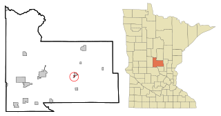
Onamia is a city in Mille Lacs County, Minnesota, United States. The population was 784 as of the 2020 census, down from 878 in 2010. U.S. Highway 169 and Minnesota State Highway 27 are the main routes in the community.
Onamia Township is a township in Mille Lacs County, Minnesota, United States. The population was 575 at the 2010 census.
Vineland is an unincorporated community and census-designated place (CDP) in the Mille Lacs Indian Reservation portion of Mille Lacs County, Minnesota, United States. The population was 869 as of the 2020 census, down from 1,001 in 2010. Its name in the Ojibwe language is Neyaashiing, meaning "on the point of land" due to its location on Indian Point of Mille Lacs Lake. It serves as the administrative center for the Mille Lacs Band of Ojibwe.
Bowlus ( BOH-ləss is a city in Morrison County, Minnesota, United States. The population was 279 at the 2020 census.
Buckman is a city in Morrison County, Minnesota, United States. The population was 307 at the 2020 Census.
Culdrum Township is a township in Morrison County, Minnesota, United States. The population was 505 at the 2000 census.
Elmdale is a city in Morrison County, Minnesota, United States. The population was 114 at the 2020 census.
Harding is a city in Morrison County, Minnesota, United States. The population was 123 at the 2020 census. There’s also a parade in winter called the Harding Horse parade and have Harding days around the Fourth of July, which attracts a few thousand people especially The rodeo
Hillman Township is a township in Morrison County, Minnesota, United States. The population was 164 at the 2000 census.
Lastrup is a city in Morrison County, Minnesota, United States. The population was 120 at the 2020 census.
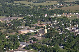
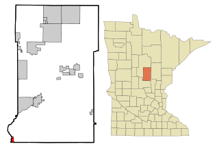
Pierz is a city in Morrison County, Minnesota, United States. The population was 1,418 at the 2020 census.
Pierz Township is a township in Morrison County, Minnesota, United States. The population was 513 at the 2000 census.
Rosing Township is a township in Morrison County, Minnesota, United States. The population was 135 at the 2000 census.
Fairfield Township is a township in Swift County, Minnesota, United States. The population was 169 at the 2000 census.
Windsor Township is a township in Traverse County, Minnesota, United States. The population was 54 at the 2000 census.
Genola is a city in Morrison County, Minnesota, United States. The population was 70 at the 2020 census.