
Calico is a ghost town and former mining town in San Bernardino County, California, United States. Located in the Calico Mountains of the Mojave Desert region of Southern California, it was founded in 1881 as a silver mining town, and was later converted into a county park named Calico Ghost Town. Located off Interstate 15, it lies 3 miles (4.8 km) equidistant from Barstow and Yermo. Giant letters spelling CALICO are visible, from the highway, on the Calico Peaks behind it. Walter Knott purchased Calico in the 1950s, and rebuilt all but the five remaining original buildings to look as they did in the 1880s. Calico received California Historical Landmark #782, and in 2005 was proclaimed by then-Governor Arnold Schwarzenegger to be California's Silver Rush Ghost Town.

The Panamint Range is a short rugged fault-block mountain range in the northern Mojave Desert, within Death Valley National Park in Inyo County, eastern California. A small part of the southern end of the range is in San Bernardino County. Dr. Darwin French is credited as applying the term Panamint in 1860 during his search for the fabled Gunsight Lode.
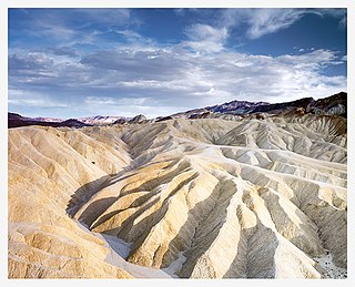
Places of interest in the Death Valley area are mostly located within Death Valley National Park in eastern California.

Freeman Junction, a ghost town in Kern County, California, USA, was first homesteaded in the early 1870s. Freeman S. Raymond built a stage coach station here to accommodate travelers between the desert mines and Los Angeles. A group of Native Americans who were defending their homes and families in 1909 killed off the homesteaders and burned the stage station, after which the property lay dormant for several years. It was re-homesteaded in the 1920s by Clare C. Miley, who was born in 1900, and his wife. By the 1930s their small stone cabin became a gas station/car repair and later, a restaurant and some mining activities dominated the site. In 1953 a post office was planned, but never materialized and residents had to travel seven miles to Inyokern to collect their mail. By June, 1978, the town had died once again and the remains of the town have since been removed by passersby. Today, the site has reverted to its natural state and nothing remains.

Panamint City is a ghost town in the Panamint Range, near Death Valley, in Inyo County, California, US. It is also known by the official Board of Geographic Names as Panamint. Panamint was a boom town founded after silver and copper were found there in 1872. By 1874, the town had a population of about 2,000. Its main street was one mile (1.6 km) long. Panamint had its own newspaper, the Panamint News. Silver was the principal product mined in the area. The town is located about three miles northwest of Sentinel Peak. According to the National Geographic Names Database, NAD27 latitude and longitude for the locale are 36°07′06″N117°05′43″W, and the feature ID number is 1661185. The elevation of this location is identified as being 6,280 feet AMSL. The similar-sounding Panamint Springs, California, is located about 25.8 miles at 306.4 degrees off true north near Panamint Junction.
The Timbisha are a Native American tribe federally recognized as the Death Valley Timbisha Shoshone Band of California. They are known as the Timbisha Shoshone Tribe and are located in south central California, near the Nevada border. As of the 2010 Census the population of the Village was 124. The older members still speak the ancestral language, also called Timbisha.
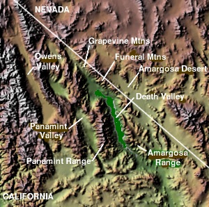
The Panamint Valley is a long basin located east of the Argus and Slate ranges, and west of the Panamint Range in the northeastern reach of the Mojave Desert, in eastern California, United States.

Ymir is a village in the Selkirk Mountains in the West Kootenay region of southeastern British Columbia. Ymir is located where the Salmo River meets Quartz Creek, and Ymir Creek. The locality, on BC Highway 6, is by road about 10 kilometres (6 mi) northeast of Salmo and 34 kilometres (21 mi) south of Nelson.

Hart was a short-lived gold mining town located in the Mojave Desert, in San Bernardino County, California. It existed between 1908 and 1915, and was located on the northeastern edge of Lanfair Valley near the New York Mountains. The area is now in the Castle Mountains National Monument, administered by the National Park Service.

The Desert Rat Scrap Book was a roughly quarterly southwestern humor publication based in Thousand Palms, California. DRSB was published in editions of 10,000 to 20,000 copies, whenever its creator, Harry Oliver had sufficient material and enough money to pay the printer. Forty-six issues were printed and distributed via Southern California bookstores and newsstands, and by mail worldwide. DRSB was devoted to lore, legends, lies and laughs of the American Southwest region, especially featuring prospectors and other desert rats. The publication was launched in late 1945 and ran through early 1967.

Searles Valley is a census-designated place (CDP) in the Searles Valley of the Mojave Desert, in northwestern San Bernardino County, California, United States.
Lookout City is a former settlement in the Mojave Desert, in Inyo County, California. It lay at an elevation of 3579 feet.

Alamo Crossing is a ghost town in Mohave County, Arizona, United States. The town was settled in the late 1890s, in what was then the Arizona Territory. It served as a camp for mining prospectors in the manganese-rich Artillery Mountains, being the only town in the area. After 1918, the post office permanently closed, but the town was only intermittently abandoned, with its founders often present through until at least the mid-1950s. The town was intentionally flooded in 1968 to create Alamo Lake. In 2020, the area of Alamo was revived for mining again, this time for surface-level gold prospecting.
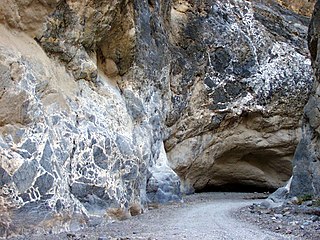
Titus Canyon is a deep, narrow gorge cut into the steep face of the Grapevine Mountains of the Mojave Desert, within Death Valley National Park in southeastern California and southwestern Nevada. The canyon features limestone rock formations, petroglyphs, and native plants and wildlife.
Crisman is an unincorporated community and a census-designated place (CDP) located in and governed by Boulder County, Colorado, United States. The CDP is a part of the Boulder, CO Metropolitan Statistical Area. The population of the Crisman CDP was 179 at the United States Census 2020. The Boulder post office serves the area.
Norton's Landing or Norton's, was a steamboat landing on the Colorado River, in what was then Yuma County, Arizona Territory. Today it is in La Paz County, Arizona. Nortons Landing is 52 miles upriver from Yuma, Arizona 4 miles above Picacho, California and 18 miles below the Clip, Arizona landing. It lies on a rocky point of land next to the river at 215 feet of elevation just east of Red Cloud Wash and Black Rock Wash, where roads to the district mines in the mountains met the Colorado River.

Lake Panamint is a former lake that occupied Panamint Valley in California during the Pleistocene. It was formed mainly by water overflowing through the Owens River and which passed through Lake Searles into the Panamint Valley. At times, Lake Panamint itself overflowed into Death Valley and Lake Manly.

The Potash wars were a series of events that took place from 1910 to 1915 in the Searles Valley near Searles Lake, a dry lake, near the current town of Trona in the San Bernardino County of California. The Potash wars gained national and international news at the time due to the involvement of famous lawman Wyatt Earp and the importance of the valley's supply of potash at the time. Potash is an important crop fertilizer and the Searles Valley was a major supplier in the 1910s.


