
Leadville is a statutory city that is the county seat, the most populous community, and the only incorporated municipality in Lake County, Colorado, United States. The city population was 2,633 at the 2020 census. It is situated at an elevation of 10,158 feet (3,096 m). Leadville is the highest incorporated city in the United States and is surrounded by two of the tallest peaks in the state.

Monument is a home rule town situated at the base of the Rampart Range in El Paso County, Colorado, United States. Monument is one of the three communities that make up the Tri-Lakes area, along with Palmer Lake and Woodmoor. Monument is bordered by Pike National Forest on the west, Colorado Springs and the United States Air Force Academy to the south, Bald Mountain, True Mountain, and Spruce Mountain to the north, and Black Forest and rolling plains to the east. Monument was first settled as a stop along the Rio Grande Railroad in 1872, and the area was incorporated as a town called Henry's Station in 1879, but the name was later changed to Monument. The town population was 10,399 at the 2020 United States Census, a 88% increase from a population of 5,530 in 2010 and a 528% increase from a population of 1,971 in 2000.

Silverton is a statutory town that is the county seat, the most populous community, and the only incorporated municipality in San Juan County, Colorado, United States. The town is located in a remote part of the western San Juan Mountains, a range of the Rocky Mountains. The first mining claims were made in mountains above the Silverton in 1860, near the end of the Colorado Gold Rush and when the land was still controlled by the Utes. Silverton was established shortly after the Utes ceded the region in the 1873 Brunot Agreement, and the town boomed from silver mining until the Panic of 1893 led to a collapse of the silver market, and boomed again from gold mining until the recession caused by the Panic of 1907. The entire town is included as a federally designated National Historic Landmark District, the Silverton Historic District.

Woodland Park is a home rule municipality in Teller County, Colorado, United States. Woodland Park is part of the Colorado Springs, CO Metropolitan Statistical Area. Many residents in this bedroom community commute to Colorado Springs. Woodland Park is surrounded by the 1,000,000-acre (400,000 ha) Pike National Forest. The population was 7,920 as of the 2020 Census.

The Territory of Colorado was an organized incorporated territory of the United States that existed from February 28, 1861, until August 1, 1876, when it was admitted to the Union as the State of Colorado.
The Carson and Colorado Railway was a U.S. 3 ft narrow gauge railroad that ran from Mound House, Nevada, to Keeler, California, below the Cerro Gordo Mines. It was incorporated on May 10, 1880, as the Carson and Colorado Railroad, and construction on the railroad began on May 31, 1880. The narrow gauge track was chosen to reduce cost. Much of the route now parallels U.S. Route 95 Alternate, U.S. Route 95, Nevada State Route 360, U.S. Route 6, and U.S. Route 395.
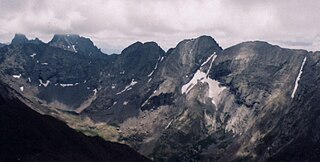
Kit Carson Peak is a high mountain summit of the Crestones in the Sangre de Cristo Range of the Rocky Mountains of North America. Officially designated Kit Carson Mountain, the 14,171-foot (4,319 m) fourteener is located 5.2 miles (8.4 km) east by south of the Town of Crestone in Saguache County, Colorado, United States. The name Kit Carson Mountain is used for both the massif with three summits, or to describe the main summit only. The mountain is named in honor of frontiersman Christopher Houston "Kit" Carson. The Crestones are a cluster of high summits in the Sangre de Cristo Range, comprising Crestone Peak, Crestone Needle, Kit Carson Peak, Challenger Point, Humboldt Peak, and Columbia Point. They are usually accessed from common trailheads.

Laws is an unincorporated community in Inyo County, California. Laws is located 4 miles (6.4 km) northeast of Bishop on U.S. Route 6, towards the Nevada state line.
Ludlow is an unincorporated community in the Mojave Desert on Interstate 40, located in San Bernardino County, California, United States. The older remains of the ghost town are along historic Route 66.
Columbia Point is a high mountain summit of the Crestones in the Sangre de Cristo Range of the Rocky Mountains of North America. The 13,986-foot (4,263 m) thirteener is located 5.5 miles (8.8 km) east by south of the Town of Crestone in Saguache County, Colorado, United States. The Crestones are a cluster of high summits in the Sangre de Cristo Range, comprising Crestone Peak, Crestone Needle, Kit Carson Peak, Challenger Point, Humboldt Peak, and Columbia Point.

Cascade is an unincorporated community and U.S. Post Office in El Paso County, Colorado, United States. The ZIP Code of the Cascade Post Office is 80809.

Lake George is an unincorporated community and a U.S. Post Office in Park County, Colorado, United States. The Lake George Post Office has the ZIP Code 80827. It lies along U.S. Highway 24 northwest of Colorado Springs, and several miles north of Florissant Fossil Beds National Monument.

Before it was founded, the site of modern-day Colorado Springs, Colorado, was part of the American frontier. Old Colorado City, built in 1859 during the Pike's Peak Gold Rush was the Colorado Territory capital. The town of Colorado Springs was founded by General William Jackson Palmer as a resort town. Old Colorado City was annexed into Colorado Springs. Railroads brought tourists and visitors to the area from other parts of the United States and abroad. The city was noted for junctions for seven railways: Denver and Rio Grande (1870), Denver and New Orleans Manitou Branch (1882), Colorado Midland (1886–1918), Colorado Springs and Interurban, Atchison, Topeka, and Santa Fe (1889), Rock Island (1889), and Colorado Springs and Cripple Creek Railways. It was also known for mining exchanges and brokers for the Cripple Creek Gold Rush.

U.S. Route 395 (US 395) is a United States Numbered Highway, stretching from Hesperia, California to the Canadian border in Laurier, Washington. The California portion of US 395 is a 557-mile (896 km) route which traverses from Interstate 15 (I-15) in Hesperia, north to the Oregon state line in Modoc County near Goose Lake. The route clips into Nevada, serving the cities Carson City and Reno, before returning to California.

The following outline is provided as an overview of and topical guide to the U.S. state of Colorado:
Owenyo was an unincorporated community in Inyo County, California. It was located on the Southern Pacific Railroad 5 miles (8 km) north of Lone Pine, at an elevation of 3697 feet. The town was abandoned in the 1960s, and all that remain now are a few traces of building foundations. There are no standing structures and no inhabitants in or anywhere near Owenyo, which remains on 21st century maps only as a reference point along the bleak, unkept and itself abandoned Owenyo-Lone Pine Road which runs about two miles east of, and running parallel with, Federal Highway 395.

Mount Mills is a Thirteener and California 4000 meter peak, on the Sierra Crest, north of Mount Abbot and south of Mono Pass in the Sierra Nevada.

Valmont is an unincorporated community and a census-designated place (CDP) located in and governed by Boulder County, Colorado, United States. The CDP is a part of the Boulder, CO Metropolitan Statistical Area. The population of the Valmont CDP was 64 at the United States Census 2020. The land use consists of farming, low-density residential, some commercial, and a few school and church properties. The Boulder post office serves the area.

Guston is a silver mining ghost town in Ouray County, Colorado, United States, 11 miles (18 km) south of Ouray following the "Million Dollar Highway". Nestled in Champion Gulch, it is located near Red Mountain and the remnants of Red Mountain Town and Ironton. The Silverton Railroad ran from Guston in the Red Mountain Pass to Silverton in San Juan County. The silver mining camp was established in 1883. The Guston post office operated from January 26, 1892, until November 16, 1898.

