Wilkerson | |
---|---|
Coordinates: 37°16′26″N118°22′30″W / 37.27389°N 118.37500°W | |
Country | United States |
State | California |
County | Inyo |
Area | |
• Total | 5.728 sq mi (14.835 km2) |
• Land | 5.727 sq mi (14.833 km2) |
• Water | 0.001 sq mi (0.002 km2) 0.013% |
Elevation | 4,403 ft (1,342 m) |
Population | |
• Total | 543 |
• Density | 95/sq mi (37/km2) |
Time zone | UTC-8 (Pacific (PST)) |
• Summer (DST) | UTC-7 (PDT) |
ZIP code | 93514 |
Area codes | 442/760 |
FIPS code | 06-85551 |
GNIS feature ID | 2409595 [2] |
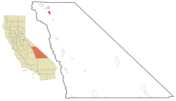
Wilkerson is a census-designated place (CDP) in Inyo County, California, United States. The population was 563 at the 2010 census, up from 562 at the 2000 census.
According to the United States Census Bureau, the CDP has a total area of 5.7 square miles (15 km2), over 99% of it land.
The 2010 United States Census [4] reported that Wilkerson had a population of 563. The population density was 98.3 inhabitants per square mile (38.0/km2). The racial makeup of Wilkerson was 524 (93.1%) White, 0 (0.0%) African American, 13 (2.3%) Native American, 5 (0.9%) Asian, 1 (0.2%) Pacific Islander, 5 (0.9%) from other races, and 15 (2.7%) from two or more races. Hispanic or Latino of any race were 53 persons (9.4%).
The Census reported that 563 people (100% of the population) lived in households, 0 (0%) lived in non-institutionalized group quarters, and 0 (0%) were institutionalized.
There were 244 households, out of which 55 (22.5%) had children under the age of 18 living in them, 151 (61.9%) were opposite-sex married couples living together, 14 (5.7%) had a female householder with no husband present, 8 (3.3%) had a male householder with no wife present. There were 10 (4.1%) unmarried opposite-sex partnerships, and 1 (0.4%) same-sex married couples or partnerships. 65 households (26.6%) were made up of individuals, and 31 (12.7%) had someone living alone who was 65 years of age or older. The average household size was 2.31. There were 173 families (70.9% of all households); the average family size was 2.76.
The population was spread out, with 100 people (17.8%) under the age of 18, 22 people (3.9%) aged 18 to 24, 88 people (15.6%) aged 25 to 44, 238 people (42.3%) aged 45 to 64, and 115 people (20.4%) who were 65 years of age or older. The median age was 51.2 years. For every 100 females, there were 101.1 males. For every 100 females age 18 and over, there were 97.9 males.
There were 265 housing units at an average density of 46.3 per square mile (17.9/km2), of which 244 were occupied, of which 200 (82.0%) were owner-occupied, and 44 (18.0%) were occupied by renters. The homeowner vacancy rate was 1.5%; the rental vacancy rate was 4.3%. 466 people (82.8% of the population) lived in owner-occupied housing units and 97 people (17.2%) lived in rental housing units.
As of the census [5] of 2000, there were 562 people, 234 households, and 160 families residing in the CDP. The population density was 98.0 inhabitants per square mile (37.8/km2). There were 245 housing units at an average density of 42.7 per square mile (16.5/km2). The racial makeup of the CDP was 94.66% White, 0.18% Native American, 0.71% Asian, 1.07% from other races, and 3.38% from two or more races. 5.16% of the population were Hispanic or Latino of any race.
There were 234 households, out of which 27.8% had children under the age of 18 living with them, 56.8% were married couples living together, 4.7% had a female householder with no husband present, and 31.2% were non-families. 27.4% of all households were made up of individuals, and 13.2% had someone living alone who was 65 years of age or older. The average household size was 2.40 and the average family size was 2.89.
In the CDP, the population was spread out, with 23.3% under the age of 18, 5.9% from 18 to 24, 21.2% from 25 to 44, 32.6% from 45 to 64, and 17.1% who were 65 years of age or older. The median age was 45 years. For every 100 females, there were 105.1 males. For every 100 females age 18 and over, there were 100.5 males.
The median income for a household in the CDP was $35,583, and the median income for a family was $55,625. Males had a median income of $39,750 versus $22,981 for females. The per capita income for the CDP was $20,182. None of the families and 4.6% of the population were living below the poverty line, including no under eighteens and 3.1% of those over 64.
In the state legislature, Wilkerson is in the 8th Senate District , represented by Democrat Angelique Ashby, [6] and the 26th Assembly District , represented by Democrat Evan Low. [7]
Federally, Wilkerson is in California's 8th congressional district , represented by Democrat John Garamendi. [8]
Mesa Vista is a census-designated place (CDP) in Alpine County, California, United States. The population was 200 at the 2010 census, up from 182 at the 2000 census.
Easton is a census-designated place (CDP) in Fresno County, California, United States. The population was 2,083 at the 2010 census, up from 1,966 at the 2000 census. Easton is located 7.5 miles (12.1 km) south of downtown Fresno, at an elevation of 276 feet.
Raisin City is a census-designated place (CDP) in Fresno County, California, United States. The population was 380 at the 2010 census, up from 165 at the 2000 census. Raisin City is located 13 miles (21 km) south-southwest of downtown Fresno, at an elevation of 236 feet.
Westhaven-Moonstone is a census-designated place (CDP) located in Humboldt County, California, United States. As of the 2010 census the population was 1,205, up from 1,044 at the 2000 census.
Round Valley is a census-designated place (CDP) in Inyo County, California, United States. Round Valley is located 7.5 miles (12 km) northeast of Mount Tom, at an elevation of 4692 feet. The population was 435 at the 2010 census, up from 278 at the 2000 census.
West Bishop is a census-designated place (CDP) in Inyo County, California, United States. The population was 2,607 at the 2010 census, down from 2,807 at the 2000 census.
Valley Acres is a census-designated place (CDP) in Kern County, California, United States. Valley Acres is located 5.2 miles (8.4 km) north-northeast of Taft, at an elevation of 420 feet (128.02 m). The population was 527 at the 2010 census, up from 512 at the 2000 census.
West Rancho Dominguez, formerly known as West Compton and also known as East Gardena, is an unincorporated census-designated place (CDP) located in southern Los Angeles County, California. Per the 2020 census, the population was 24,347. The community lies to the west of the city of Compton. The ZIP Codes encompassing the CDP area are 90220 & 90248.
Meadow Vista is a census-designated place (CDP) in Placer County, California, United States. It is part of the Sacramento–Arden-Arcade–Roseville Metropolitan Statistical Area. The population was 3,217 at the 2010 census, up from 3,096 at the 2000 census.
Keddie is a census-designated place in Plumas County, California, United States. The population was 66 at the 2010 census.
Mohawk Vista is a census-designated place in Plumas County, California, United States. The population was 159 at the 2010 census, up from 121 at the 2000 census.
Taylorsville is a census-designated place (CDP) in Plumas County, California, United States. The population was 150 at the 2010 census, down from 154 at the 2000 census. The annual Stone Ranch Reunion is held in Taylorsville.
El Cerrito is a census-designated place (CDP) in Riverside County, California, United States. It is an unincorporated area mostly surrounded by the city of Corona. The population was 5,100 at the 2010 census, up from 4,590 at the 2000 census.
Lakeview is a census-designated place (CDP) in Riverside County, California, United States. The population was 2,104 at the 2010 census, up from 1,619 at the 2000 census. The community is named for nearby Mystic Lake.
Lenwood is a census-designated place (CDP) in the Mojave Desert near Barstow, in San Bernardino County, California.
Hidden Meadows is a census-designated place (CDP) near Escondido in San Diego County, California. The population was 3,485 at the 2010 census, up from 3,463 at the 2000 census.
Spring Valley is a census-designated place (CDP) in the East County region of San Diego County, California. The population was 28,205 at the time of the 2010 census.
Eldridge is a census-designated place (CDP) in Sonoma County, California, United States. The population was 1,233 at the 2010 census. It is notably the home to the Sonoma Developmental Center, the largest facility serving the needs of persons with developmental disabilities in the state.
Tipton is a census-designated place (CDP) in Tulare County, California, United States. The population was 2,543 at the 2010 census, up from 1,790 at the 2000 census.
Riverside is a hamlet and census-designated place (CDP) in Suffolk County, New York, United States. The population was 2,911 at the 2010 census.