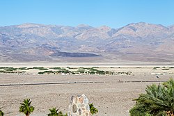
Death Valley is a desert valley in Eastern California, in the northern Mojave Desert, bordering the Great Basin Desert. It is thought to be the hottest place on Earth during summer. Death Valley is home to the Timbisha tribe of Native Americans, formerly known as the Panamint Shoshone, who have inhabited the valley for at least the past millennium.

Furnace Creek, formerly Greenland Ranch, is a census-designated place (CDP) in Inyo County, California, United States. The population was 136 at the 2020 census, up from 24 at the 2010 census. The elevation of the village is 190 feet (58 m) below sea level. The visitor center, museum, and headquarters of the Death Valley National Park are located at Furnace Creek.
The Shoshone or Shoshoni are a Native American tribe with four large cultural/linguistic divisions:

The Goshutes are a tribe of Western Shoshone Native Americans. There are two federally recognized Goshute tribes today:

The Indigenous peoples of the Great Basin are Native Americans of the northern Great Basin, Snake River Plain, and upper Colorado River basin. The "Great Basin" is a cultural classification of indigenous peoples of the Americas and a cultural region located between the Rocky Mountains and the Sierra Nevada, in what is now Nevada, and parts of Oregon, California, Idaho, Wyoming, and Utah. The Great Basin region at the time of European contact was ~400,000 sq mi (1,000,000 km2). There is very little precipitation in the Great Basin area which affects the lifestyles and cultures of the inhabitants.
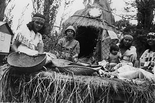
Timbisha (Tümpisa) or Panamint is the language of the Native American people who have inhabited the region in and around Death Valley, California, and the southern Owens Valley since late prehistoric times. There are a few elderly individuals who can speak the language in California and Nevada, but none are monolingual, and all use English regularly in their daily lives. Until the late 20th century, the people called themselves and their language "Shoshone." The tribe then achieved federal recognition under the name Death Valley Timbisha Shoshone Band of California. This is an Anglicized spelling of the native name of Death Valley, tümpisa, pronounced, which means "rock paint" and refers to the rich sources of red ochre in the valley. Timbisha is also the language of the so-called "Shoshone" groups at Bishop, Big Pine, Darwin, Independence, and Lone Pine communities in California and the Beatty community in Nevada. It was also the language spoken at the former Indian Ranch reservation in Panamint Valley.
The Bannock War of 1878 was an armed conflict between the U.S. military and Bannock and Paiute warriors in Idaho and northeastern Oregon from June to August 1878. The Bannock totaled about 600 to 800 in 1870 because of other Shoshone peoples being included with Bannock numbers. They were led by Chief Buffalo Horn, who was killed in action on June 8, 1878. After his death, Chief Egan led the Bannocks. He and some of his warriors were killed in July by a Umatilla party that entered his camp in subterfuge.

Western Shoshone comprise several Shoshone tribes that are indigenous to the Great Basin and have lands identified in the Treaty of Ruby Valley 1863. They resided in Idaho, Nevada, California, and Utah. The tribes are very closely related culturally to the Paiute, Goshute, Bannock, Ute, and Timbisha tribes.

Death Valley Junction, more commonly known as Amargosa, is a tiny Mojave Desert unincorporated community in Inyo County, California, at the intersection of SR 190 and SR 127, in the Amargosa Valley and just east of Death Valley National Park. The zip code is 92328, the elevation is 2,041 ft (622 m), and the population is fewer than four people.

The Wind River Indian Reservation, in the west-central portion of the U.S. state of Wyoming, is shared by two Native American tribes, the Eastern Shoshone and the Northern Arapaho. Roughly 60 mi (97 km) east to west by 50 mi (80 km) north to south, the Indian reservation is located in the Wind River Basin, and includes portions of the Wind River Range, Owl Creek Mountains, and Absaroka Range.

The Mono are a Native American people who traditionally live in the central Sierra Nevada, the Eastern Sierra, the Mono Basin, and adjacent areas of the Great Basin. They are often grouped under the historical label "Paiute" together with the Northern Paiute and Southern Paiute – but these three groups, although related within the Numic group of Uto-Aztecan languages, do not form a single, unique, unified group of Great Basin tribes.
The Big Pine Band of Owens Valley Paiute Shoshone Indians of the Big Pine Reservation are a federally recognized tribe of Mono and Timbisha Indians in California.
The Timbisha are a Native American tribe federally recognized as the Death Valley Timbisha Shoshone Band of California. They are known as the Timbisha Shoshone Tribe and are located in south central California, near the Nevada border. As of the 2010 Census the population of the Village was 124. The older members still speak the ancestral language, also called Timbisha.

The Tübatulabal are an indigenous people of Kern River Valley in the Sierra Nevada range of California. They may have been the first people to make this area their permanent home. Today many of them are enrolled in the Tule River Indian Tribe. They are descendants of the people of the Uto-Aztecan language group, separating from Shoshone people about 3000 years ago.
The Bishop Paiute Tribe, formerly known as the Paiute-Shoshone Indians of the Bishop Community of the Bishop Colony is a federally recognized tribe of Mono and Timbisha Indians of the Owens Valley, in Inyo County of eastern California. As of 2022, the United States census showed the Bishop Paiute Tribe's population at 1,914.
The Paiute-Shoshone Indians of the Lone Pine Community of the Lone Pine Reservation is a federally recognized tribe of Mono and Timbisha Native American Indians near Lone Pine in Inyo County, California. They are related to the Owens Valley Paiute.
Death Valley Unified School District (DVUSD) is a public school district in Inyo County, California. DVUSD is located in eastern Inyo County and borders the state of Nevada. It serves the entire southeast region of Inyo County and covers approximately 6,000 square miles (16,000 km2) of the Mojave Desert. The total population within this region is about 1,000, and DVUSD is the only school district to serve this population. Three communities served by DVUSD are located in Death Valley National Park.