Coast Miwok

Last updated

Coast Miwok People
KuleLoklo3272.jpg
Modern reconstructions of Coast Miwok shelters at Kule Loklo
Total population
1770: 2,000
1850: 250
1880: 60
2000: 167 [1]
Regions with significant populations
California:

Marin County

Sonoma County
Languages
Utian:
Coast Miwok
Religion
Shamanism: Kuksu:
Miwok mythology
Related ethnic groups
Miwok

Plains & Sierra Miwok
Lake Miwok

Bay Miwok

The Coast Miwok are an Indigenous people of California that were the second-largest tribe of the Miwok people. Coast Miwok inhabited the general area of modern Marin County and southern Sonoma County in Northern California, from the Golden Gate north to Duncans Point and eastward to Sonoma Creek. Coast Miwok included the Bodega Bay Miwok, or Olamentko (Olamentke), from authenticated Miwok villages around Bodega Bay, the Marin Miwok, or Hookooeko (Huukuiko), and Southern Sonoma Miwok, or Lekahtewutko (Lekatuit). While they did not have an overarching name for themselves, the Coast Miwok word for people, Micha-ko, was suggested by A. L. Kroeber as a possible endonym, [2] keeping with a common practice among tribal groups and the ethnographers studying them in the early 20th Century and with the term Miwok itself, which is the Central Sierra Miwok word for people.

Contents

Map of Coast Miwok tribelets Coast Miwok tribelets.svg
Map of Coast Miwok tribelets

Culture

Basket made by Miwok at the Oakland Museum of California Basket, Miwok, before 1917 - Oakland Museum of California - DSC05048.JPG
Basket made by Miwok at the Oakland Museum of California
Abalone shells gathered from the coast were used to make jewelry. Abalone necklace, Miwok - Oakland Museum of California - DSC04942.JPG
Abalone shells gathered from the coast were used to make jewelry.

The Coast Miwok spoke their own Coast Miwok language in the Utian linguistic group. They lived by hunting and gathering, and lived in small bands without centralized political authority. In the springtime they would head to the coasts to hunt salmon and other seafood, including seaweed. [3] Otherwise their staple foods were primarily acorns—particularly from black and tan oak–nuts and wild game, such as deer and cottontail rabbits and black-tailed deer, Odocoileus hemionus columbianus , a coastal subspecies of the California mule deer, Odocoileus hemionus . [4] When hunting deer, Miwok hunters traditionally used Brewer's angelica, Angelica breweri to eliminate their own scent. [5] Miwok did not typically hunt bears. [6] Yerba buena tea leaves were used medicinally. [7]

Tattooing was a traditional practice among Coast Miwok, and they burned poison oak for a pigment. [8] Their traditional houses, called "kotcha", were constructed with slabs of tule grass or redwood bark in a cone-shaped form. [9]

Miwok people are skilled at basketry. A recreated Coast Miwok village called Kule Loklo is located at the Point Reyes National Seashore.

Cultural subdivisions

In C. Hart Merriam's discussions with Coast Miwok peoples, he identified three cultural tribes:

These tribes did not have a political structure and so are not "tribes" in that sense. [12] Rather, chiefs or headmen (oi-bu in Olamentko [13] and hoipu in Hookooeko) were empowered at the tribelet level. The Coast Miwok did not have a single name for all three tribes, describing themselves instead by tribe, tribelet, or village, depending on the context. Using Merriam's divisions, the tribelets as shown on the map to the right - itself derived from Milliken [12] - can be classified as:

Language

The Coast Miwok language is still spoken, but the Bodega dialect, spoken by the Olamentko group, is documented in Callaghan (1970). From speaking with Coast Miwok people in the early 1900s, Merriam believed that the Lekahtewutko and Hookooeko dialects were substantially the same. [10]

Religion

Coast Miwok people's world view included animism, and one form this took was the Kuksu religion that was evident in Central and Northern California. This included elaborate acting and dancing ceremonies in traditional costume, an annual mourning ceremony, puberty rites of passage, shamanic intervention with the spirit world and an all-male society that met in subterranean dance rooms. [14] [15] Kuksu was shared with other indigenous ethnic groups of Central California, such as their neighbors the Pomo, also Maidu, Ohlone, Esselen, and northernmost Yokuts. However Kroeber observed less "specialized cosmogony" in the Miwok, which he termed one of the "southern Kuksu-dancing groups", in comparison to the Maidu and other northern California tribes. [16]

Coast Miwok mythology and narratives were similar to those of other natives of Central and Northern California. The Coast Miwok believed in animal and human spirits, and saw the animal spirits as their ancestors. Coyote was seen as their ancestor and creator god. In their stories, the Earth began with land formed out of the Pacific Ocean. [17]

Traditional narratives

In their myths, legends, tales, and histories, the Coast Miwok participated in the general cultural pattern of Central California. [14]

Villages

The authenticated Coast Miwok villages are: [18]

History

Illustration from a 1590 book: Francis Drake's 1579 expedition reportedly had friendly relations with Californian natives. Drake CA 1590.jpg
Illustration from a 1590 book: Francis Drake's 1579 expedition reportedly had friendly relations with Californian natives.
Balthazar, Inhabitant of Northern California, painted by Mikhail Tikhanov 1818 Tikhanov - Balthazar Inhabitant of Northern California (1818).png
Balthazar, Inhabitant of Northern California, painted by Mikhail Tikhanov 1818

Documentation of Miwok peoples dates back as early as 1579 by a priest on a ship under the command of Sir Francis Drake. Other verification of occupancy exists from Spanish and Russian voyagers between 1595 and 1808. [19] [20] Over 1000 prehistoric charmstones and numerous arrowheads have been unearthed at Tolay Lake in Southern Sonoma County - some dating back 4000 years. The lake was thought to be a sacred site and ceremonial gathering and healing place for the Miwok and others in the region. [21]

Coast Miwok would travel and camp on the coast and bays at peak fishing seasons.

After the Europeans arrived in California, the population declined from diseases introduced by the Europeans. Beginning in 1783, mission ecclesiastical records show that Coast Miwok individuals began to join Mission San Francisco de Asis, now known as Mission Dolores. They started joining that mission in large numbers in 1803, when the marriages of 49 couples from their Huimen and Guaulen local tribes (San Rafael and Bolinas Bay) appeared in the Mission San Francisco Book of Marriages. [22] Local tribes from farther and farther north along the shore of San Pablo Bay moved to Mission San Francisco through the year 1812. Then in 1814 the Spanish authorities began to split the northern groups—Alagualis, Chocoimes (alias Sonomas), Olompalis, and Petalumas—sending a portion of each group to Mission San Francisco and another portion to Mission San Jose in the southeast portion of the San Francisco Bay Area. By the end of the year 1817, 850 Coast Miwok had been converted. [23]

Mission San Rafael was founded by the Spanish Franciscans in Coast Miwok territory in the late fall of 1817. By that time the only Coast Miwok people still on their land were those on the Pacific Coast of the Marin Peninsula, from Point Reyes north to Bodega Bay. [24] The Spanish authorities brought most of the Coast Miwoks who had been at Missions San Francisco and San Jose back north to form a founding population for Mission San Rafael. [25] But some who had married Ohlone or Bay Miwok-speaking Mission Indians remained south of the Golden Gate. Over time in the 1820s Mission San Rafael became a mission for Coast Miwok and Pomo speakers. Mission San Francisco Solano, founded in 1823 in the Sonoma Valley (the easternmost traditional Coast Miwok region), came to be predominately a mission for Indians that spoke the Wappo or Patwin languages. [26]

At the end of the Mission period (1769–1834) the Coast Miwoks were freed from the control of the Franciscan missionaries. At the same time the Mission lands were secularized and ceded to Californios. Most Coast Miwok began to live in servitude on the ranchos for the new California land grant owners, such as those who went to work for General Mariano G. Vallejo at Rancho Petaluma Adobe. The ranch owners were dependent upon the labor pool of Indians with agricultural and ranching skills. [19] [20] Other Miwok chose to live independently in bands like those at Rancho Olompali and Rancho Nicasio.

In 1837, a smallpox epidemic decimated all the native populations of the Sonoma region, and the Coast Miwok population continued to decline rapidly from other diseases brought in from the Spaniards as well as the Russians at Fort Ross. [20] [27]

By the beginning of California statehood (1850), many Miwok of Marin and Sonoma Counties were making the best of a difficult situation by earning their livelihoods through farm labor or fishing within their traditional homelands. Others chose to work as seasonal or year-round laborers on the ranches that were rapidly passing from Mexican ownership into Anglo-American ownership. [20] [28]

Olompali and Nicasio

After Mission San Rafael closed during the 1834-1836 period, the Mexican government deeded most of the land to Californios, but allowed the Miwok ex-neophytes to own land at two locations within traditional Coast Miwok territory: Olompali and Nicasio.

The Coast Miwok leader Camilo Ynitia, secured a land grant of 2 sq. leagues known as Rancho Olompali, from Governor Micheltorena of Alta California in 1843, which included the prehistoric Miwok village of Olompali (his home village) and is north of present-day Novato. [29]

The village of Olompali dates back to 500, had been a main center in 1200, and might have been the largest Miwok village in Marin County. [30] Ynitia held onto the Rancho Olompoli land title for 9 years, but in 1852 he sold most of the land to James Black of Marin. [30] He retained 1,480 acres (6.0 km2) called Apalacocha. His daughter eventually sold Apalacocha.

The other Miwok-owned rancho was at Rancho Nicasio northwest of San Rafael. Near the time of secularization (1835), the Church granted the "San Rafael Christian Indians" 20 leagues (80,000 acres, 320 km2) of Mission lands from present-day Nicasio to the Tomales Bay. About 500 Miwok people relocated to Rancho Nicasio. By 1850 they had one league of land left. This radical reduction of land was a result of illegal confiscation of land by Europeans under protest by native residents. In 1870, José Calistro, the last community leader at Nicasio, purchased the small surrounding parcel. Calistro died in 1875, and in 1876 the land was transferred by his will to his four children. In 1880 there were 36 Miwok people at Nicasio. The population was persuaded to leave in the 1880s when Marin County curtailed funds to all Miwok (except those at Marshall) who were not living at the Poor Farm, a place for indigent peoples. [31]

Some Coast Miwok persons were enslaved. In 1846, Joseph Warren Revere (career militant and grandson of Paul Revere) purchased Rancho San Geronimo. It was 8,701 acres of Coast Miwok land, first seized by Manuel Micheltorena in 1844 during the Mexican-American war. [32] Revere forced enslaved Coast Miwok people to operate the plantation, [33] [34] selling timber and crops. [32]

By the early 20th century, a few Miwok families pursued fishing for their livelihoods; one family continued commercial fishing into the 1970s, while another family maintained an oyster harvesting business. When this activity was neither in season nor profitable, Miwok people of this area sought agricultural employment, which required an itinerant lifestyle. The preferred locality for such work was within Marin and Sonoma counties.

Recognition

The Federated Indians of Graton Rancheria, formerly the Federated Coast Miwok, gained federal recognition of their tribal status in December 2000. The new tribe consists of people of both Coast Miwok and Southern Pomo descent.

Population

Estimates for the pre-contact populations of most native groups in California have varied substantially. (See Population of Native California.) Alfred L. Kroeber put the 1770 population of the Coast Miwok at 1,500. [35] Sherburne F. Cook raised this figure to 2,000. [23]

The population in 1848 was estimated as 300, and it had dropped to 60 in 1880. [36]

Notable Coast Miwoks

See also

Notes

  1. "2000 census" (PDF).
  2. Kroeber, A. L. (1925). Handbook of the Indians of California. Smithsonian Institution Bureau of American Ethnology Bulletin 78. Washington, DC: Government Printing Office. p. 274.
  3. Lightfoot and Parrish 216
  4. Lightfoot and Parrish 247, 335
  5. Lightfoot and Parrish 335
  6. Lightfoot and Parrish 334
  7. Lightfoot and Parrish 219, 223
  8. Lightfoot and Parrish 229
  9. Lightfoot and Parrish 225
  10. 1 2 Merriam, C. Hart (1907). "Distribution and Classification of the Mewan Stock of California". American Anthropologist. 9 (2): 338–357. doi: 10.1525/aa.1907.9.2.02a00080 . ISSN   0002-7294. JSTOR   659593.
  11. Hoshino, Lina (August 16, 2022). "Another Perspective: Coast Miwok elder wants his Petaluma heritage to be respected". Petaluma Argus-Courier. Retrieved October 17, 2022.
  12. 1 2 3 Milliken, Randall (2009). Ethnohistory and Ethnogeography of the Coast Miwok and Their Neighbors, 1783-1840 (PDF). Oakland, CA: National Park Service.
  13. Von Wrangell, F. P.; Kostromitonov, P.; Heizer, R. F. (1974) [1839]. Ethnographic Observations on the Coast Miwok and Pomo (PDF). Translated by Stross, Fred. Berkeley: University of California. p. 15.
  14. 1 2 Kroeber, 1907, Vol. 4 #6, sections titled "Shamanism", "Public Ceremonies", "Ceremonial Structures and Paraphernalia", and "Mythology and Beliefs".
  15. The Kuksu Cult paraphrased from Kroeber. Archived October 11, 2006, at the Wayback Machine
  16. Kroeber, 1925:445. "A less specialized type of cosmogony is therefore indicated for the southern Kuksu-dancing groups. [1. If, as seems probable, the southerly Kuksu tribes (the Miwok, Costanoans, Esselen, and northernmost Yokuts) had no real society in connection with their Kuksu ceremonies, the distinctness of their mythology appears less surprising.]".
  17. Clark 1910, Gifford 1917.
  18. "Miwok Indian Tribe". Access Genealogy. Retrieved January 11, 2008.
  19. 1 2 3 Cook, 1976.
  20. 1 2 3 4 Silliman, 2004.
  21. Tolay Lake Park: Natural and Cultural History Archived 2008-04-03 at the Wayback Machine , County of Sonoma Regional Parks Department: Tolay Lake Regional Park Archived 2008-02-03 at the Wayback Machine , August 20, 2007.
  22. Milliken 1995:176-179
  23. 1 2 Cook, 1976:182.
  24. Goerke 2007:49, 70
  25. Goerke 2007:71-77; Milliken 2008:60
  26. Milliken 2008:59-60,64
  27. Cook 1976:213-214.
  28. Goerke 2007:155-168
  29. Goerke 2007; Shumway 1988:39.
  30. 1 2 Reutinger 1997.
  31. 1 2 Goerke 2007
  32. 1 2 Chemerka, WIlliam R. General Joseph Warren Revere: The Gothic Saga of Paul Revere's Grandson. BearManor Media.
  33. "Marin history: Next stop, Lagunitas station". Marin Independent Journal. November 27, 2017. Retrieved June 16, 2022.
  34. San Geronimo Valley Historical Society, "A brief history of potato farming in the #sangeronimovalley", May 1, 2020.
  35. Kroeber 1925:883
  36. Cook, 1976:239, 351.
  37. 1 2 3 Goerke, Betty. 2007. Chief Marin, Leader, Rebel, and Legend: A History of Marin County's Namesake and his People. Berkeley: Heyday Books. ISBN   978-1-59714-053-9
  38. 1 2 Teather, 1986
  39. Teather has full name and acreage

Related Research Articles

<span class="mw-page-title-main">Ohlone</span> Native American people of the Northern California coast

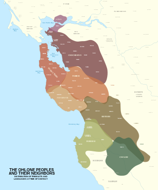
The Ohlone, formerly known as Costanoans, are a Native American people of the Northern California coast. When Spanish explorers and missionaries arrived in the late 18th century, the Ohlone inhabited the area along the coast from San Francisco Bay through Monterey Bay to the lower Salinas Valley. At that time they spoke a variety of related languages. The Ohlone languages make up a sub-family of the Utian language family. Older proposals place Utian within the Penutian language phylum, while newer proposals group it as Yok-Utian.

<span class="mw-page-title-main">Miwok</span> Members of four linguistically related Native American groups

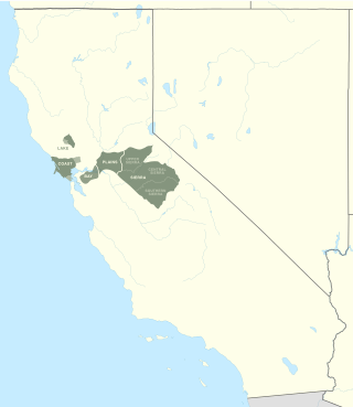
The Miwok are members of four linguistically related Native American groups indigenous to what is now Northern California, who traditionally spoke one of the Miwok languages in the Utian family. The word Miwok means people in the Miwok languages.

The Bay Miwok are a cultural and linguistic group of Miwok, a Native American people in Northern California who live in Contra Costa County. They joined the Franciscan mission system during the early nineteenth century, suffered a devastating population decline, and lost their language as they intermarried with other native California ethnic groups and learned the Spanish language.

<span class="mw-page-title-main">Bodega Bay</span> Archaeological site in California, United States

Bodega Bay is a shallow, rocky inlet of the Pacific Ocean on the coast of northern California in the United States. It is approximately 5 mi (8 km) across and is located approximately 40 mi (60 km) northwest of San Francisco and 20 mi (32 km) west of Santa Rosa. The bay straddles the boundary between Sonoma County to the north and Marin County to the south. The bay is a marine habitat used for navigation, recreation, and commercial and sport fishing.

The Federated Indians of Graton Rancheria, formerly known as the Federated Coast Miwok, is a federally recognized American Indian tribe of Coast Miwok and Southern Pomo Indians. The tribe was officially restored to federal recognition in 2000 by the U.S. government pursuant to the Graton Rancheria Restoration Act.

<span class="mw-page-title-main">Lake Miwok</span> Branch of the Miwok

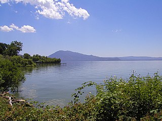
The Lake Miwok are a branch of the Miwok, a Native American people of Northern California. The Lake Miwok lived in the Clear Lake basin of what is now called Lake County. While they did not have an overarching name for themselves, the Lake Miwok word for people, Hotsa-ho, was suggested by A. L. Kroeber as a possible endonym, keeping with a common practice among tribal groups and the ethnographers studying them in the early 20th Century and with the term Miwok itself, which is the Central Sierra Miwok word for people.

<span class="mw-page-title-main">Plains and Sierra Miwok</span> Largest group of California Indian Miwok people

The Plains and Sierra Miwok were once the largest group of California Indian Miwok people, Indigenous to California. Their homeland included regions of the Sacramento Valley, San Joaquin Valley, and the Sierra Nevada.

<span class="mw-page-title-main">Olompali State Historic Park</span> 700-acre State park in Marin County, California

Olompali State Historic Park is a 700-acre (2.8 km2) California State Park in Marin County, California. It is constituted of the former Rancho Olómpali and was the site of the famed Battle of Olómpali during the Bear Flag Revolt. Rancho Olómpali was purchased by the Californian government in 1977, which turned it into a public park.

Tolay Creek is a 12.5-mile-long (20.1 km) southward-flowing stream in southern Sonoma County, California, United States, which flows through Tolay Lake and ends in north San Pablo Bay.

Camilo Ynitia was born in 1803, in Marin County, southern Marin, of the Huiman tribe near Sausalito. They likely traveled up to Olompali, where his father had built an adobe brick home. Camilo was a notable leader of the Coast Miwok, a Native American people. Camilo was known as the last Hoipu (headman) of the Miwok community living at Olompali and the Coast Miwoks of the Southern Marin Band. Camilo was also the only Native American on the northern frontier of Alta California to secure and keep a large Mexican-era land grant: In 1843 Governor Manuel Micheltorena of Alta California deeded him the Rancho Olompali, a large tract of land that is between present-day Novato and Petaluma, California. A part of this land now comprises the Olompali State Historic Park.

<span class="mw-page-title-main">Nicasio Creek</span> River in California, United States

Nicasio Creek is an 11.9-mile-long (19.2 km) stream in Marin County, California, United States and is the primary tributary of Lagunitas Creek, which flows, in turn, into Tomales Bay, and the Pacific Ocean. The Nicasio Reservoir, formed in 1961 by Seeger Dam, is located on this stream.

Tomales High School is located in the town of Tomales, California, United States. It is the comprehensive high school of the Shoreline Unified School District. It serves the western Marin and Sonoma County communities, stretching from the towns of Point Reyes Station and Inverness along Tomales Bay, running north past the fishing port of Bodega Bay to the mouth of the Russian River, a distance of nearly 50 miles (80 km), and widening 13 miles (21 km) east from the west coast. Tomales High School draws its students from approximately 450 square miles (1,200 km2). Tomales High School was recognized as a California Distinguished School in 2011.

The Battle of Olómpali was fought on June 24, 1846, between a rebel group supporting an independent California Republic and a Mexican army force under the command of Joaquín de la Torre. It was the only battle of the Bear Flag Revolt. The encounter took place in present-day Marin County, California at a site that is now part of the Olompali State Historic Park.

<span class="mw-page-title-main">Rancho Olómpali</span>

Rancho Olómpali was a 8,877-acre (35.92 km2) Mexican land grant in present-day Marin County, California given in 1834 by governor Manuel Micheltorena to Camilo Ynitia, son of a Coast Miwok chief. The name Olómpali comes from the Coast Miwok language and likely means southern village or southern people. The land grant is between present-day Novato and Petaluma. A part of this land now comprises the Olompali State Historic Park.

José Calistro was the last chief of the Coast Miwok community who resided at Rancho Nicasio, which was once a Native American rancho that stretched from present-day Nicasio, California to Tomales Bay.

Chief Marin was the "great chief of the tribe Licatiut", according to General Vallejo's semi-historical report to the first California State Legislature in 1850. Historical records indicate that he was baptized as a young man at Mission San Francisco de Asís in 1801 and eventually moved to Mission San Rafael Arcángel, where he was an alcalde in the 1820s. Marin died on March 15, 1839, of natural causes. Marin County and the Marin Islands are believed to be named in his honor.

Rancho Nicasio was a Mexican land grant of 56,807 acres (230 km2) granted to the Coast Miwok indigenous people in 1835, located in the present-day Marin County, California, a tract of land that stretched from San Geronimo to Tomales Bay. Today, Nicasio, California is at the heart of this location.

Olompali is a former Native American settlement in Marin County, California. It was located 5 miles (8 km) south of Petaluma.

The Shoreline Unified School District serves the West Marin and Sonoma County communities stretching from the towns of Point Reyes Station and Inverness along Tomales Bay running north past the fishing port of Bodega Bay to the mouth of the Russian River, a distance of nearly 50 miles (80 km) and widens 13 miles (21 km) east from the west coast. Shoreline Unified draws its students from approximately 450 square miles.

Tsupu, also known as Wild Cucumber, Maria Chekka, and Maria Chica, was a Coast Miwok elder. She was the last native of the ancient village of Petaluma, which was east of the Petaluma River and about three and a half miles northeast of the present city of Petaluma, California. It was part of Lekatuit Nation and had around 500 residents. "Petaluma" means "sloping ridge" in the Coast Miwok language.

References

Further reading