Estero de San Antonio

Last updated
Estero de San Antonio [1]
EsteroDeSanAntonio3179.jpg
Estero de San Antonio in 2008
Other name(s)San Antonio Creek
Etymology Spanish Saint Anthony's Estuary
Country United States
State California
Region Marin and Sonoma counties
Physical characteristics
Source 
 - location1.5 mi (2.4 km) southwest of Bloomfield, California
 - coordinates 38°18′11″N122°52′37″W / 38.30306°N 122.87694°W / 38.30306; -122.87694 [1]
 - elevation400 ft (120 m)
River mouth Bodega Bay
 - coordinates 38°16′12″N122°58′46″W / 38.27000°N 122.97944°W / 38.27000; -122.97944 Coordinates: 38°16′12″N122°58′46″W / 38.27000°N 122.97944°W / 38.27000; -122.97944 [1]
 - elevation0 ft (0 m)
Length9.5 mi (15.3 km) [1]
Basin features
Basin size50 sq mi (130 km2) [2]
Tributaries 
 - left Stemple Creek

Estero de San Antonio is a stream in the northern California counties of Marin and Sonoma which empties into Bodega Bay.

Stream A body of surface water flowing down a channel

A stream is a body of water with surface water flowing within the bed and banks of a channel. The stream encompasses surface and groundwater fluxes that respond to geological, geomorphological, hydrological and biotic controls.

California State of the United States of America

California is a state in the Pacific Region of the United States. With 39.6 million residents, California is the most populous U.S. state and the third-largest by area. The state capital is Sacramento. The Greater Los Angeles Area and the San Francisco Bay Area are the nation's second and fifth most populous urban regions, with 18.7 million and 9.7 million residents respectively. Los Angeles is California's most populous city, and the country's second most populous, after New York City. California also has the nation's most populous county, Los Angeles County, and its largest county by area, San Bernardino County. The City and County of San Francisco is both the country's second-most densely populated major city after New York City and the fifth-most densely populated county, behind only four of the five New York City boroughs.

Marin County, California County in California, United States

Marin County is a county located in the San Francisco Bay Area of the U.S. state of California. As of the 2010 census, the population was 252,409. Its county seat is San Rafael. Marin County is included in the San Francisco-Oakland-Hayward, CA Metropolitan Statistical Area across the Golden Gate Bridge from San Francisco.

Contents

Course

The Estero springs just north of the Marin-Sonoma county line (from a hill overlooking Bloomfield, California) and runs south along Gericke Road into Marin County. Just north of Fallon-Two Rock Road, it turns west, flowing under the road just east of State Route 1. It flows south along the highway for 0.25 mi (0.4 km), then crosses under the highway at milepost 47.6 and continues west to a confluence with Stemple Creek 0.3 mi (0.5 km) southeast of Fallon, California. From there, it winds its way westward, passing under Middle Road and Valley Ford Franklin School Road before emptying into Bodega Bay 1.5 mi (2.4 km) north of Dillon Beach, California.

Bloomfield, California census-designated place in California, United States

Bloomfield is a census-designated place in Sonoma County, California, U.S. It is located in a rural area about 11 miles (18 km) southwest of Santa Rosa, California at the junction of Bloomfield Road and Valley Ford Road. Americano Creek flows westward along the south edge of the town.

California State Route 1 highway in California

State Route 1 (SR 1) is a major north–south state highway that runs along most of the Pacific coastline of the U.S. state of California. At a total of just over 659 miles (1,061 km), it is the longest state route in California. SR 1 has several portions designated as either Pacific Coast Highway (PCH), Cabrillo Highway, Shoreline Highway, or Coast Highway. Its southern terminus is at Interstate 5 (I-5) near Dana Point in Orange County and its northern terminus is at U.S. Route 101 (US 101) near Leggett in Mendocino County. SR 1 also at times runs concurrently with US 101, most notably through a 54-mile (87 km) stretch in Ventura and Santa Barbara counties, and across the Golden Gate Bridge.

Stemple Creek stream in California

Stemple Creek is a 16 mi (26 km) long, westward-flowing stream in the California counties of Sonoma and Marin, which feeds into the Estero de San Antonio. Its waters ultimately reach Bodega Bay, part of the Gulf of the Farallones National Marine Sanctuary on the Pacific Ocean.

Ecology

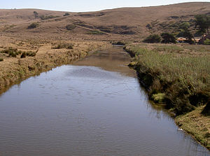
The Estero de San Antonio has a variety of habitat types, including freshwater ponds, mudflats, eelgrass and saltgrass area, and wooded ravines. It is estimated that the Estero has 923 acres (374 ha) of associated wetlands. [3]

In the summer or early fall, a sandbar often forms at the mouth of the Estero, damming it until the winter rains arrive. Area residents used to blast the sandbar to dispel high salt concentrations in the Estero. [2]

Nomenclature

The United States Geological Survey's Geographic Names Information System cites ten variant names for this stream, including Stemple Creek (the name of its main tributary), Estero De Americano (almost identical to the parallel estuary 2 mi (3 km) north), Arroyo de San Antonio (also applied to Walker Creek, a parallel estuary 5 mi (8 km) south), and San Antonio Creek (the name of a creek further east along the county line). [1] In particular, the Estero's watershed is often referred to as the Stemple Creek watershed. [4] The stream is also referred to as Fallon Creek. [5]

United States Geological Survey Scientific agency of the United States government

The United States Geological Survey is a scientific agency of the United States government. The scientists of the USGS study the landscape of the United States, its natural resources, and the natural hazards that threaten it. The organization has four major science disciplines, concerning biology, geography, geology, and hydrology. The USGS is a fact-finding research organization with no regulatory responsibility.

Geographic Names Information System geographical database

The Geographic Names Information System (GNIS) is a database that contains name and locative information about more than two million physical and cultural features located throughout the United States of America and its territories. It is a type of gazetteer. GNIS was developed by the United States Geological Survey in cooperation with the United States Board on Geographic Names (BGN) to promote the standardization of feature names.

Walker Creek (Marin County, California)

Walker Creek is a northwest-flowing stream in western Marin County, California, United States. It originates at the confluence of Salmon Creek and Arroyo Sausal and empties into Tomales Bay south of Dillon Beach, California.

Bridges

The Estero de San Antonio is crossed by three concrete continuous slab bridges:

Concrete slab common structural element of modern buildings

A concrete slab is a common structural element of modern buildings. Horizontal slabs of steel reinforced concrete, typically between 4 and 20 inches thick, are most often used to construct floors and ceilings, while thinner slabs are also used for exterior paving. Sometimes these thinner slabs, ranging from 2 inches (51 mm) to 6 inches (150 mm) thick, are called mud slabs, particularly when used under the main floor slabs or in crawl spaces.

It is also crossed at Fallon-Two Rock Road by a 22 ft (7 m) concrete tee beam bridge built in 1932. [5]

See also

Related Research Articles

Sonoma County, California County in California, United States

Sonoma County is a county in the U.S. state of California. As of the 2010 United States Census, its population was 483,878. Its county seat and largest city is Santa Rosa. It is to the north of Marin County and the south of Mendocino County. It is west of Napa County and Lake County.

Coast Miwok tribe of Native American people

The Coast Miwok are an indigenous people that was the second largest group of Miwok people. The Coast Miwok inhabited the general area of modern Marin County and southern Sonoma County in Northern California, from the Golden Gate north to Duncans Point and eastward to Sonoma Creek. The Coast Miwok included the Bodega Bay Miwok, from authenticated Miwok villages around Bodega Bay, and the Marin Miwok.

Bodega Bay inlet in California

Bodega Bay is a shallow, rocky inlet of the Pacific Ocean on the coast of northern California in the United States. It is approximately 5 mi (8 km) across and is located approximately 40 mi (60 km) northwest of San Francisco and 20 mi (32 km) west of Santa Rosa. The bay straddles the boundary between Sonoma County to the north and Marin County to the south. The bay is a marine habitat used for navigation, recreation, and commercial and sport fishing including shellfish harvesting.

Bodega Harbor harbor in California

Bodega Harbor is a small shallow natural harbor on the Pacific coast of northern California in the United States, approximately 40 mi (64 km) northwest of San Francisco. The harbor is approximately 2 square miles in area.

Petaluma River river in California

The Petaluma River is a river in the California counties of Sonoma and Marin that becomes a tidal slough for the majority of its length. The headwaters are in the area southwest of Cotati. The flow is generally southward through Petaluma's old town, where the waterway becomes navigable, and then flows another 10 mi (16 km) through tidal marshes before emptying into the northwest corner of San Pablo Bay.

San Antonio Creek may refer to any of the following waterways in California, United States:

Russian River (California) river in California

The Russian River is a southward-flowing river that drains 1,485 sq mi (3,850 km2) of Sonoma and Mendocino counties in Northern California. With an annual average discharge of approximately 1,600,000 acre feet (2.0 km3), it is the second-largest river flowing through the nine-county Greater San Francisco Bay Area, with a mainstem 110 mi (180 km) long.

Americano Creek stream in California

Americano Creek is a 7.5-mile (12 km) long westward-flowing stream in the California counties of Sonoma and Marin. It flows into the Estero Americano, a 9.2 mi (15 km) long estuary, and thence to the Pacific Ocean. This article covers both watercourses.

Hydrography of the San Francisco Bay Area

The Hydrography of the San Francisco Bay Area is a complex network of watersheds, marshes, rivers, creeks, reservoirs, and bays predominantly draining into the San Francisco Bay and Pacific Ocean.

San Antonio Creek is a northward then eastward-flowing stream in the California, United States, counties of Marin and Sonoma that forms part of the boundary between those counties. It empties into the tidal portion of the Petaluma River.

Salmon Creek (Sonoma County, California) stream in California

Salmon Creek is an 18.3-mile-long (29.5 km) stream in western Sonoma County, California that springs from coastal hills west of the town of Occidental and empties into the Pacific Ocean north of Bodega Head.

Atascadero Creek (Sonoma County, California) creek in Sonoma County, California

Atascadero Creek is an 8.8-mile-long (14.2 km) north-flowing stream in Sonoma County, California, United States, which empties into Green Valley Creek.

Windsor Creek stream in California

Windsor Creek is an 8.8-mile-long (14.2 km) southward-flowing stream in Sonoma County, California, United States, which rises near Healdsburg, California, and feeds into Mark West Creek west of the Sonoma County Airport. Its waters reach the Pacific Ocean by way of the Russian River.

Novato Creek river in the United States of America

Novato Creek is a stream in eastern Marin County, California, United States. It originates in highlands between Red Hill and Mount Burdell above the city of Novato, California, and flows 17 miles (27 km) before emptying into San Pablo Bay south of Petaluma Point.

Miller Creek (Marin County, California) river in the United States of America

Miller Creek is a 7.6-mile-long (12.2 km) stream in eastern Marin County, California, United States. It originates on Big Rock Ridge and empties into San Pablo Bay east of Marinwood. A middle school called Miller Creek Middle School was named after the creek and is home to 6th, 7th, and 8th graders.

Estero Americano State Marine Recreational Management Area

Estero Americano State Marine Recreational Management Area (SMRMA) is a marine protected area that splits Sonoma and Marin counties on California’s north central coast. The marine protected area covers 0.15 square miles. Estero Americano SMRMA prohibits the take of all living marine resources, except the recreational hunting of waterfowl, unless otherwise restricted by hunting regulations.

Estero de San Antonio State Marine Recreational Management Area

Estero de San Antonio State Marine Recreational Management Area (SMRMA) is a marine protected area 1.5 miles north of Dillon Beach in Marin County on California’s north central coast. The marine protected area covers 0.09 square miles. Estero de San Antonio SMRMA prohibits the take of all living marine resources, except the recreational hunting of waterfowl, unless otherwise restricted by hunting regulations.

Rancho Blucher was a 26,759-acre (108.29 km2) Mexican land grant in present day Marin and Sonoma County, California given in 1844 by Governor Manuel Micheltorena to Jean Jacques Vioget. The rancho is named for the Prussian field marshal Gebhard Leberecht von Blücher. The grant extended along the coast from Estero Americano on the north and to Estero de San Antonio on the south.

Corte Madera Creek (Marin County, California) river in United States of America

Corte Madera Creek is a short stream which flows southeast for 4.5 miles (7.2 km) in Marin County, California. Corte Madera Creek is formed by the confluence of San Anselmo Creek and Ross Creek in Ross and entering a tidal marsh at Kentfield before connecting to San Francisco Bay near Corte Madera.

References

  1. 1 2 3 4 5 U.S. Geological Survey Geographic Names Information System: Estero de San Antonio
  2. 1 2 "Marin County Watershed Management Plan Administrative Draft" (PDF). Archived from the original (PDF) on July 24, 2011. Retrieved 2008-03-03.
  3. "Estero de San Antonio - Mouth of the Stemple Creek Watershed". Archived from the original on 2007-06-15. Retrieved 2007-12-10.
  4. "The Stemple Creek Watershed Project". Archived from the original on 2007-12-04. Retrieved 2007-12-10.
  5. 1 2 "National Bridge Inventory Database". Archived from the original on 2013-10-31.