
Inverness is an unincorporated community and census-designated place (CDP) in western Marin County, California, United States. It is located on the southwest shore of Tomales Bay 3.5 miles northwest of Point Reyes Station and about 40 miles (65 km) by road northwest of San Francisco, at an elevation of 43 feet. In the 2020 census, the population was 1,379. The community was named by a Scottish landowner after Inverness in Scotland.
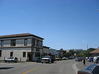
Point Reyes Station is a small unincorporated town in western Marin County, California, United States. Point Reyes Station is located 13 miles (21 km) south-southeast of Tomales, at an elevation of 39 feet (12 m). Point Reyes Station is located along State Route 1 and is a gateway to the Point Reyes National Seashore, an extremely popular national preserve. The Point Reyes Station census-designated place (CDP) covers the unincorporated town and adjacent development to the north, with a total population of 895 as of the 2020 census.

Point Reyes National Seashore is a 71,028-acre (287.44 km2) park preserve located on the Point Reyes Peninsula in Marin County, California. As a national seashore, it is maintained by the US National Park Service as an important nature preserve. Some existing agricultural uses are allowed to continue within the park. Clem Miller, a US Congressman from Marin County, wrote and introduced the bill for the establishment of Point Reyes National Seashore in 1962 to protect the peninsula from development which was proposed at the time for the slopes above Drake's Bay.
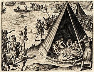
New Albion, also known as Nova Albion, was the name of the continental area north of Mexico claimed by Sir Francis Drake for England when he landed on the North American west coast in 1579. This claim became the justification for English charters across America to the Atlantic coast and soon influenced further national expansion projects on the continent. Drake's landing site has been identified as Drake's Cove, which is part of Point Reyes National Seashore.
The Miwok are members of four linguistically related Native American groups Indigenous to what is now Northern California, who traditionally spoke one of the Miwok languages in the Utian family. The word Miwok means people in the Miwok languages.

The Coast Miwok are an Indigenous people of California that were the second-largest tribe of the Miwok people. Coast Miwok inhabited the general area of present-day Marin County and southern Sonoma County in Northern California, from the Golden Gate north to Duncans Point and eastward to Sonoma Creek. Coast Miwok included the Bodega Bay Miwok, or Olamentko (Olamentke), from authenticated Miwok villages around Bodega Bay, the Marin Miwok, or Hookooeko (Huukuiko), and Southern Sonoma Miwok, or Lekahtewutko (Lekatuit). While they did not have an overarching name for themselves, the Coast Miwok word for people, Micha-ko, was suggested by A. L. Kroeber as a possible endonym, keeping with a common practice among tribal groups and the ethnographers studying them in the early 20th century and with the term Miwok itself, which is the Central Sierra Miwok word for 'people'.
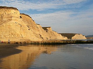
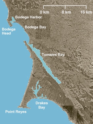
Drakes Bay is a 4 mi (6 km) wide bay named so by U.S. surveyor George Davidson in 1875 along the Point Reyes National Seashore on the coast of northern California in the United States, approximately 30 mi (50 km) northwest of San Francisco at approximately 38 degrees north latitude. The bay is approximately 8 mi (13 km) wide. It is formed on the lee side of the coastal current by Point Reyes. The bay is named after Sir Francis Drake and has long been considered Drake's most likely landing spot on the west coast of North America during his circumnavigation of the world by sea in 1579. An alternative name for this bay is Puerto De Los Reyes.
Point Reyes is a prominent landform and popular Northern California tourist destination on the Pacific coast. Located in Marin County, it is approximately 30 miles (50 km) west-northwest of San Francisco. The term is often applied to the Point Reyes Peninsula, the region bounded by Tomales Bay on the northeast and Bolinas Lagoon on the southeast. The majority of the peninsula as well as the headlands are protected as part of Point Reyes National Seashore.

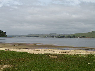
Tomales Bay is a long, narrow inlet of the Pacific Ocean in Marin County in northern California in the United States. It is approximately 15 mi (24 km) long and averages nearly 1.0 mi (1.6 km) wide, effectively separating the Point Reyes Peninsula from the mainland of Marin County. It is located approximately 30 mi (48 km) northwest of San Francisco. The bay forms the eastern boundary of Point Reyes National Seashore. Tomales Bay is recognized for protection by the California Bays and Estuaries Policy. On its northern end, it opens out onto Bodega Bay, which shelters it from the direct current of the Pacific. The bay is formed along a submerged portion of the San Andreas Fault.
The Federated Indians of Graton Rancheria, formerly known as the Federated Coast Miwok, is a federally recognized American Indian tribe of Coast Miwok and Southern Pomo Indians. The tribe was officially restored to federal recognition in 2000 by the U.S. government pursuant to the Graton Rancheria Restoration Act.

Olema is an unincorporated community in Marin County, California. It is located on Olema Creek 2.25 miles (3.6 km) south-southeast of Point Reyes Station, at an elevation of 69 feet.
Tomales Bay State Park is a California state park in Marin County, California. It consists of approximately 2,000 acres (8 km²) divided between two areas, one on the west side of Tomales Bay and the other on the east side. The main area, on the west, is part of the Point Reyes peninsula, and adjacent to Point Reyes National Seashore, which is operated by the U.S. National Park Service. The park is approximately 40 miles (64 km) north of San Francisco.
The Graton Rancheria was a 15.45-acre (62,500 m2) property in the coastal hills of northern California, about two miles (3 km) northwest of Sebastopol. The site is about 1.5 miles (2.4 km) southwest of the hamlet of Graton, population 1,815 in 2000. The area is a few miles west of Santa Rosa, the largest of Sonoma County's nine cities and the County seat, population 147,595 in 2000. It was a former rancheria for Central Coast and Central valley tribes, including the Southern Pomo, a Hokan-speaking tribe, and Coast Miwok.
Tomales High School is located in the town of Tomales, California, United States. It is the comprehensive high school of the Shoreline Unified School District. It serves the western Marin and Sonoma County communities, stretching from the towns of Point Reyes Station and Inverness along Tomales Bay, running north past the fishing port of Bodega Bay to the mouth of the Russian River, a distance of nearly 50 miles (80 km), and widening 13 miles (21 km) east from the west coast. Tomales High School draws its students from approximately 450 square miles (1,200 km2). Tomales High School was recognized as a California Distinguished School in 2011.

KPH is a coast radio station on the Pacific Coast of the United States. For most of the 20th century, it provided ship to shore communications including telegrams and marine telex service. The station discontinued commercial operation in 1998, but is operated occasionally as a historic service – its signal can be received over a large portion of the western hemisphere.

Duxbury Reef State Marine Conservation Area (SMCA) is a marine protected area located about 1 mile (2 km) west of Bolinas in Marin County on California’s north central coast. This marine protected area covers 0.66 square miles (1.7 km2). Duxbury Reef SMCA prohibits the take of all living marine resources, except the recreational take of finfish from shore only and the recreational take of abalone.
Estero de Limantour State Marine Reserve (SMR) and Drakes Estero State Marine Conservation Area (SMCA) are two adjoining marine protected areas along the Point Reyes National Seashore in Marin County on California’s north central coast. These marine protected areas cover a combined 4.04 square miles (10.5 km2), with 1.49 square miles (3.9 km2) in the SMR and 2.55 square miles (6.6 km2) in the SMCA. Drakes Estero SMCA prohibits the take of all living marine resources from Drakes Estero except the recreational take of clams and formerly the commercial aquaculture of shellfish pursuant to a disputed state water bottom lease and permit, which has been the subject of ongoing legal proceedings since 2012, when the lease was allowed to expire.
Point Reyes State Marine Reserve (SMR) and Point Reyes State Marine Conservation Area (SMCA) are two adjoining marine protected areas that extend offshore of Point Reyes Headlands and within Drakes Bay in Marin County on California's north central coast. The combined area of these marine protected areas is 21.49 square miles (55.7 km2), with 9.38 in the SMR, and 12.11 in the adjacent SMCA. Point Reyes SMR prohibits the take of all living marine resources. Point Reyes SMCA prohibits the take of all living marine resources, except the recreational and commercial take of Dungeness crab by pot and salmon by trolling.

Julia Florence Parker is a Coast Miwok-Kashaya Pomo basket weaver.
Sir and Star is a restaurant founded in 2012. It is located in The Olema, a historic restaurant and inn built in 1876. The restaurant is at the corner of Sir Francis Drake Boulevard and Star Route One in Olema, California. Olema is located in West Marin County 1 mile from the Bear Valley portal to the Point Reyes National Seashore.

