
Inyo County is a county in the eastern central part of the U.S. state of California, located between the Sierra Nevada and the state of Nevada. In the 2020 census, the population was 19,016. The county seat is Independence. Inyo County is on the east side of the Sierra Nevada and southeast of Yosemite National Park in Central California. It contains the Owens River Valley; it is flanked to the west by the Sierra Nevada and to the east by the White Mountains and the Inyo Mountains. With an area of 10,192 square miles (26,400 km2), Inyo is the second-largest county by area in California, after San Bernardino County. Almost one-half of that area is within Death Valley National Park. However, with a population density of 1.8 people per square mile, it also has the second-lowest population density in California, after Alpine County.
Independence is a census-designated place in Inyo County, California. Independence is located 41 miles (66 km) south-southeast of Bishop, at an elevation of 3930 feet. It is the county seat of Inyo County, California. The population of this census-designated place was 669 at the 2010 census, up from 574 at the 2000 census.

Tecopa is a census-designated place (CDP) in southeast Inyo County, California, United States. It was established in the late 19th century as mining town. It is now better known for the natural hot springs north of the current townsite.

The California Water Wars were a series of political conflicts between the city of Los Angeles and farmers and ranchers in the Owens Valley of Eastern California over water rights.

Area codes 760 and 442 are telephone area codes in the North American Numbering Plan (NANP) for the U.S. state of California. These area codes serve an overlay numbering plan area (NPA) that comprises much of the southeastern and southernmost portions of California. It includes Imperial, Inyo, and Mono counties, as well as portions of San Diego, Riverside, San Bernardino, Los Angeles and Kern counties. Area code 760 was created on March 22, 1997 in a split of area code 619. Area code 442 was added to the same area on November 21, 2009.

Inyo National Forest is a United States National Forest covering parts of the eastern Sierra Nevada of California and the White Mountains of California and Nevada. The forest hosts several superlatives, including Mount Whitney, the highest point in the contiguous United States; Boundary Peak, the highest point in Nevada; and the Ancient Bristlecone Pine Forest, which protects the oldest living trees in the world. The forest, encompassing much of the Owens Valley, was established by Theodore Roosevelt as a way of sectioning off land to accommodate the Los Angeles Aqueduct project in 1907, making the Inyo National Forest one of the least wooded forests in the U.S. National Forest system.

Mount Russell is a peak in the Sierra Nevada mountain range in the U.S. state of California, about 0.8 miles (1.3 km) north of Mount Whitney. Possessing an elevation of 14,094 feet (4,296 m), it is the seventh-highest peak in the state and one of California's twelve fourteeners.
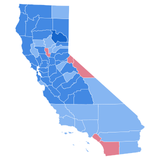
The 1964 United States presidential election in California took place on November 3, 1964 as part of the 1964 United States presidential election. State voters chose 40 representatives, or electors, to the Electoral College, who voted for president and vice president.

This is a list of the National Register of Historic Places listings in Inyo County, California.
Charleston View, formally known as Calvada Springs, is an unincorporated community in Inyo County, California. It lies at an elevation of 2621 feet. The Charleston View CDP had a population of 45 in the 2020 census
Harrisburg is an unincorporated community in Inyo County, California. It lies at an elevation of 4987 feet.
Reward was an mining site in Inyo County, California. It is located on the west side of the Inyo Mountains 9.5 miles (15 km) north of Lone Pine, at an elevation of 3865 feet.
Sunland is a former settlement in Inyo County, California. It lay at an elevation of 4209 feet.
San Carlos is a former settlement in Inyo County, California. It was founded in 1863 and was located on the east bank of the Owens River 4 miles (6.4 km) east of Independence, close by to the west of the later site of Kearsarge, California.
Inyo County v. Paiute-Shoshone Indians of the Bishop Community, 538 U.S. 701 (2003), was a United States Supreme Court case.
Coso County was a failed attempt in California to create a county from the territory of Tulare County and parts of Mono County east of the Sierra Nevada in 1864. It was the predecessor of Inyo County, which was successfully organized in 1866.
The California Department of Housing and Community Development (HCD) is a department within the California Business, Consumer Services and Housing Agency that develops housing policy and building codes, regulates manufactured homes and mobilehome parks, and administers housing finance, economic development and community development programs.

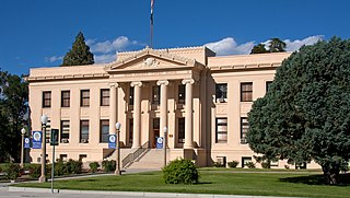
The Superior Court of California, County of Inyo, also known as the Inyo County Superior Court or Inyo Superior Court, is the branch of the California superior court with jurisdiction over Inyo County.
Sandy Valley is the southeastern most unincorporated community, in Inyo County, California, located in the Mesquite Valley. The population in the 2020 for sandy valley is in census tract 8, Block 1330–1333 was of 4.


