Halloran Springs is a set of springs in the Mojave Desert in San Bernardino County, California, United States. It is located on Interstate 15 between Baker, California and Las Vegas, Nevada approximately 15 miles (24 km) northeast of Baker.

Willow Springs is a village located around a set of former springs in Kern County, California, United States. It is located 7.5 miles (12 km) west of Rosamond, at an elevation of 2,523 feet (769 m).

Deep Springs is a set of artesian springs in Inyo County, California that were used for irrigation. It lies within the treaty territory of the Western Bands of the Shoshone Nation of Indians. It is located in the northeastern section of Deep Springs Valley, 22 miles (35 km) east of Bishop, 2.6 km (1.6 mi) north of Soldier Pass, and 6.4 km (4 mi) southwest of Chocolate Mountain, at an elevation of 5194 feet.
Mark West Springs is set of springs in eastern Santa Rosa, California that were used as a resort since 1880 and perhaps earlier. Mark West Springs is located on Porter Creek Road in the Mayacamas Mountains. Mark West Creek flows through the community.
Mendenhall Springs is a set of springs that was turned into a resort in Alameda County, California. It is located 9 miles (14 km) southeast of Livermore, at an elevation of 1818 feet.
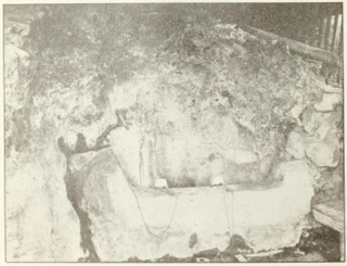
Fouts Springs is a set of springs that became a resort in the 19th century in Colusa County, California. It lies at an elevation of 1713 feet. It is best known for being the headquarters of the New Tribes Mission. The post office was established in 1882, closed in 1913, reopened in 1945, closed again in 1947, reopened in 1950 and closed for good in 1956. The place is named for John F. Fouts who discovered the springs here in 1873. The springs supported a resort capable of hosting 150 guests that operated here in the early part of the 20th century. Fouts Spring water was being bottled for sale as drinking water as of 1909.
Wentworth Springs is a set of springs that was once the site of a settlement and a camping resort in El Dorado County, California. It was located 11.5 miles (19 km) west of Meeks Bay.
Alder Springs is a set of springs and an unincorporated community in Glenn County, California. It is located 10.5 miles (17 km) west-northwest of Elk Creek, at an elevation of 4455 feet.
Kane Spring is a spring in Imperial County, California. It is located 1.9 km (1.2 mi) south-southwest of San Felipe Wash and 8 km (5 mi) west of the southwestern extension of the Salton Sea, at an elevation of 141 feet below sea level.
Gypsite was a small community at the site of a mill in Kern County, California.
Hough Springs is a set of springs that was turned into a resort in the 19th century in Lake County, California.

Witter Springs is a set of springs that was turned into a resort in the 1870s in Lake County, California.
Indian Springs is a small set of springs after which a nearby mining settlement was named in the 19th century, in Nevada County, California, located near Rough and Ready. It had a post office from 1858 to 1871, and again from 1892 until 1893. Indian Springs was listed on a map as of 1949.
Duncan Springs is a set of springs and the site of a resort from the 1880s in Mendocino County, California.Waring 1915, p. 167 It is located 1.5 miles (2.4 km) south-southwest of Hopland, at an elevation of 781 feet.
Orrs Springs is a set of springs around which grew a resort and a stagecoach station in Mendocino County, California. It is located 15 miles (24 km) almost directly north of Boonville, at an elevation of 1001 feet. However, it is accessible from Ukiah by following Orr Springs Rd.
Soda Springs is a spring in Mendocino County, California. It is located 5 miles (8 km) northeast of Boonville, at an elevation of 1388 feet.
Vichy Springs is a set of springs around which formed a resort in Mendocino County, California, United States. It is located on Sulphur Creek 3 miles (4.8 km) east-northeast of Ukiah, at an elevation of 801 feet.

The Benton Hot Springs are in Mono County, California around which grew the town of Benton. It is located 3 miles (4.8 km) west-southwest of Benton and 31 miles (50 km) north-northwest of Bishop, at an elevation of 5630 feet. It is part of the Benton census-designated place for statistical purposes.
Napa Soda Springs is a set of natural water springs that was the site of a resort in the 1880's in Napa County, California. It lies at an elevation of 705 feet. Napa Soda Springs is located 5 miles (8.0 km) east-southeast of Yountville.
Soda Springs is a set of springs in Placer County, California that was in the 19th century once the location of a hotel and resort. Soda Springs is located on the North Fork of the American River, 2 miles (3.2 km) west of Tinker Knob, and 4 miles (6.4 km) north-northwest of Granite Chief. It lies at an elevation of 6047 feet.


