California is a U.S. state on the western coast of North America. Covering an area of 163,696 sq mi (423,970 km2), California is among the most geographically diverse states. The Sierra Nevada, the fertile farmlands of the Central Valley, and the arid Mojave Desert of the south are some of the geographic features of this U.S. state. It is home to some of the world's most exceptional trees: the tallest, most massive, and oldest. It is also home to both the highest and lowest points in the 48 contiguous states.

The Funeral Mountains is a short, arid mountain range in the United States along the California-Nevada border approximately 100 mi (160 km) west of Las Vegas. The mountains are considered a subrange of the Amargosa Range that form the eastern wall of Death Valley.

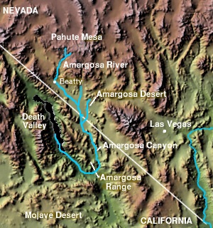
The Amargosa River is an intermittent waterway, 185 miles (298 km) long, in southern Nevada and eastern California in the United States. The Amargosa River is one out of two rivers located in the California portion of the Mojave Desert with perennial flow. It drains a high desert region, the Amargosa Valley in the Amargosa Desert northwest of Las Vegas, into the Mojave Desert, and finally into Death Valley where it disappears into the ground aquifer. Except for a small portion of its route in the Amargosa Canyon in California and a small portion at Beatty, Nevada, the river flows above ground only after a rare rainstorm washes the region. A 26-mile (42 km) stretch of the river between Shoshone and Dumont Dunes is protected as a National Wild and Scenic River. At the south end of Tecopa Valley the Amargosa River Natural Area protects the habitat.
The Amargosa Valley is the valley through which the Amargosa River flows south, in Nye County, southwestern Nevada and Inyo County in the state of California. The south end is alternately called the "Amargosa River Valley'" or the "Tecopa Valley." Its northernmost point is around Beatty, Nevada and southernmost is Tecopa, California, where the Amargosa River enters into the Amargosa Canyon.

Rhyolite is a ghost town in Nye County, in the U.S. state of Nevada. It is in the Bullfrog Hills, about 120 miles (190 km) northwest of Las Vegas, near the eastern boundary of Death Valley National Park.
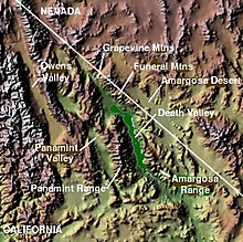
Places of interest in the Death Valley area are mostly located within Death Valley National Park in eastern California.

The Amargosa Range is a mountain range in Inyo County, California, San Bernardino County, California and Nye County, Nevada. The 110-mile (180 km) range runs along most of the eastern side of California's Death Valley, separating it from Nevada's Amargosa Desert. The U-shaped Amargosa River flows clockwise around the perimeter of the range, ending 282 feet (86 m) below sea level in the Badwater Basin.
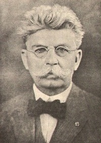
Francis Marion Smith was an American miner, business magnate and civic builder in the Mojave Desert, the San Francisco Bay Area, and Oakland, California. He was known nationally and internationally as "Borax Smith" and "The Borax King", as his company produced the popular 20-Mule-Team Borax brand of household cleaner.
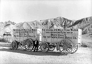
The Pacific Coast Borax Company (PCB) was a United States mining company founded in 1890 by the American borax magnate Francis Smith, the "Borax King".
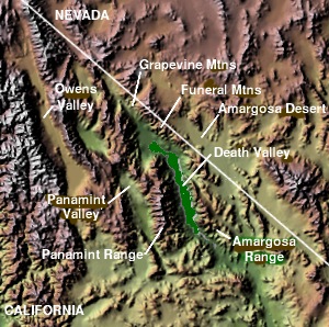
The Owlshead Mountains are at the southern end of Death Valley National Park near the border of the Fort Irwin Military Reservation in Inyo and San Bernardino Counties, California, US.

The Amargosa Desert is located in Nye County in western Nevada, United States, along the California–Nevada border, comprising the northeastern portion of the geographic Amargosa Valley, north of the Ash Meadows National Wildlife Refuge.

The Greenwater Range is a mountain range located in the eastern Mojave Desert in Inyo County, California. They are located west of the section of California State Route 127 north of Shoshone, California.

The Resting Spring Range is found in the eastern Mojave Desert of California near the Nevada state line in the United States. The range lies in a generally north–south direction to the west of the Nopah Range and southeast of the Amargosa Range and Greenwater Range.

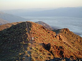
Dante's View is a viewpoint terrace at 1,669 m (5,476 ft) height, on the north side of Coffin Peak, along the crest of the Black Mountains, overlooking Death Valley. Dante's View is about 25 km (16 mi) south of Furnace Creek in Death Valley National Park.

The Fish Lake Valley is a 25 miles (40 km) long endorheic valley in southwest Nevada, one of many contiguous inward-draining basins collectively called the Great Basin. The alluvial valley lies just northwest of Death Valley and borders the southeast, and central-northeast flank of the massif of the White Mountains of California. The southwestern portion of the valley lies in California, with the southern tip at the edge of Inyo County east of the Chocolate Mountains, and a significant portion of the south end of the valley floor including the ranching community of Oasis, in Mono County. The valley is sparsely populated, primarily with ranchers and indigenous Paiute. The valley's Post Office and commercial services are located in the town of Dyer.

The Bullfrog Hills are a small mountain range of the Mojave Desert in southern Nye County, southwestern Nevada. Bullfrog Hills was so named from a fancied resemblance of its ore to the color of a bullfrog.

Ryan is an unincorporated community in Inyo County, California that is now privately owned and stewarded by the Death Valley Conservancy. A former mining community and company town, Ryan is situated at an elevation of 3,045 feet (928 m) in the Amargosa Range, and is 8 miles (13 km) northeast of Dante's View and 15 miles (24 km) southeast of Furnace Creek.

Amargosa Opera House and Hotel is a historic building and cultural center located in Death Valley Junction, in eastern Inyo County, California near Death Valley National Park.

The Buckskin Mountains is a mountain range in La Paz County, Arizona, United States. The range lies just east of the north–south Colorado River, and borders south of the east–west, west-flowing Bill Williams River.
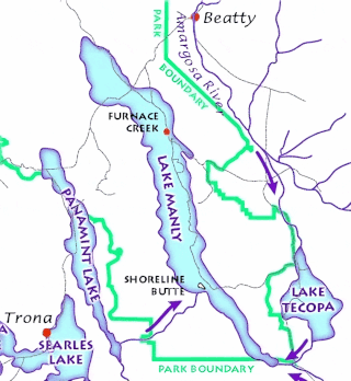
Lake Tecopa is a former lake in Inyo County, southern California. It developed during the Miocene and the Pleistocene within a tectonic basin close to the border with Nevada. Fed by the Amargosa River and some neighbouring washes, it eventually culminated to a surface area of 235 square kilometres (91 sq mi) around 186,000 years ago and left sediments. Afterwards, the Amargosa River cut a gorge out of the lake and into Death Valley with its Lake Manly, draining the lake. The present-day towns of Shoshone, California and Tecopa, California lie within the basin of the former lake.