
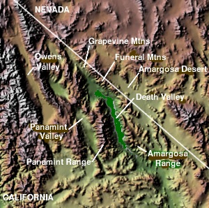
The Funeral Mountains are a short, arid mountain range in the United States along the California-Nevada border approximately 100 mi (160 km) west of Las Vegas. The mountains are considered a subrange of the Amargosa Range that form the eastern wall of Death Valley.

The Amargosa River is an intermittent waterway, 185 miles (298 km) long, in southern Nevada and eastern California in the United States. It drains a high desert region, the Amargosa Valley in the Amargosa Desert northwest of Las Vegas, into the Mojave Desert, and finally into Death Valley where it disappears into the ground aquifer. Except for a small portion of its route in the Amargosa Canyon in California and a small portion at Beatty, Nevada, the river flows above ground only after a rare rainstorm washes the region. A 26-mile (42 km) stretch of the river between Shoshone and Dumont Dunes is protected as a National Wild and Scenic River. At the south end of Tecopa Valley the Amargosa River Natural Area protects the habitat.

Amargosa Valley is an unincorporated town located on U.S. Route 95 in Nye County, in the U.S. state of Nevada.
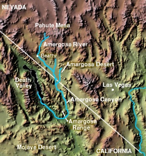
The Amargosa Valley is the valley through which the Amargosa River flows south, in Nye County, southwestern Nevada and Inyo County in the state of California. The south end is alternately called the "Amargosa River Valley'" or the "Tecopa Valley." Its northernmost point is around Beatty, Nevada and southernmost is Tecopa, California, where the Amargosa River enters into the Amargosa Canyon.
Jackass Flats is a shallow alluvial basin located in the southwest portion of the Nevada National Security Site in Nye County, Nevada. The area lies east of Yucca Mountain, south of the Calico Hills and Shoshone Mountain and northwest of Skull Mountain. The valley drains to the southwest via the Tonopah and Fortymile washes into the Amargosa Valley across US Route 95 at the town of Amargosa Valley, Nevada. The "flat" covers an area of approximately 120 square miles (310 km2) and ranges in elevation from about 2,800 ft (850 m) just north of US 95 to 4,000 ft (1,200 m) at the mountain bases to the north and east.

Places of interest in the Death Valley area are mostly located within Death Valley National Park in eastern California.

The Amargosa Range is a mountain range in Inyo County, California and Nye County, Nevada. The 110-mile (180 km) range runs along most of the eastern side of California's Death Valley, separating it from Nevada's Amargosa Desert. The U-shaped Amargosa River flows clockwise around the perimeter of the range, ending 282 feet (86 m) below sea level in the Badwater Basin.

Death Valley Junction, also known as Amargosa, is a tiny Mojave Desert unincorporated community in Inyo County, California, at the intersection of SR 190 and SR 127, in the Amargosa Valley and just east of Death Valley National Park. The zip code is 92328, the elevation is 2,041 ft (622 m), and the population is fewer than 4.

The Death Valley '49ers were a group of pioneers from the Eastern United States that endured a long and difficult journey during the late 1840s California Gold Rush to prospect in the Sutter's Fort area of the Central Valley and Sierra Nevada in California. Their route from Utah went through the Great Basin Desert in Nevada, and Death Valley and the Mojave Desert in Southern California, in attempting to reach the Gold Country.
The Owlshead Mountains are located at the southern end of Death Valley National Park near the border of the Fort Irwin Military Reservation in San Bernardino County, California, US.

The Amargosa Desert is located in Nye County in western Nevada, United States, along the California–Nevada border, comprising the northeastern portion of the geographic Amargosa Valley, north of the Ash Meadows National Wildlife Refuge
The Black Mountains are a mountain range located in the southeastern part of Inyo County, California, within southeastern Death Valley National Park.

The Resting Spring Range is found in the eastern Mojave Desert of California near the Nevada state line in the United States. The range lies in a generally north-south direction to the west of the Nopah Range and southeast of the Amargosa Range and Greenwater Range.

Greenwater was an unincorporated community near Death Valley located in the eastern side of the Inyo County, California. It is now a deserted ghost town.

Dante's View is a viewpoint terrace at 1,669 m (5,476 ft) height, on the north side of Coffin Peak, along the crest of the Black Mountains, overlooking Death Valley. Dante's View is about 25 km (16 mi) south of Furnace Creek in Death Valley National Park.

The Bullfrog Hills are a small mountain range of the Mojave Desert in southern Nye County, southwestern Nevada. Bullfrog Hills was so named from a fancied resemblance of its ore to the color of a bullfrog.

The Dumont Hills are a low mountain range in the Mojave Desert, in northeastern San Bernardino County, southern California.
The Sperry Hills are a low mountain range in the northern Mojave Desert—southern Amargosa Desert region, in northeastern San Bernardino County, southern California.
The Tecopa Hills are a mountain range of the Mojave Desert in extreme eastern Inyo County, California.

Lake Tecopa is a former lake in Inyo County, southern California. It developed during the Miocene and the Pleistocene within a tectonic basin close to the border with Nevada. Fed by the Amargosa River and some neighbouring washes, it eventually culminated to a surface area of 235 square kilometres (91 sq mi) around 186,000 years ago and left sediments. Afterwards, the Amargosa River cut a gorge out of the lake and into Death Valley with its Lake Manly, draining the lake. The present-day towns of Shoshone, California and Tecopa, California lie within the basin of the former lake.

