
Augusta is an unincorporated community and census-designated place (CDP) in Lewis and Clark County, Montana, United States. The population was 309 at the 2010 census and rose to 316 in the 2020 census. The most accepted version in the naming of this town is after Augusta Hogan, thought to be the first child born in this town, the daughter of J. D. Hogan, an early rancher.

Evaro is a census-designated place (CDP) in Missoula County, Montana, United States, and part of the Missoula metropolitan area. It is located on the southernmost part of the Flathead Indian Reservation, approximately 20 miles (32 km) north of downtown Missoula via US Highway 93. As of the 2020 census, the population of the CDP was 373, up from 322 in 2010.

Spring Creek is a census-designated place (CDP) in central Elko County, in northeastern Nevada in the western United States. It mainly serves as a bedroom community for the businesses and industries in and around the nearby city of Elko. It is part of the Elko Micropolitan Statistical Area. The population was 12,361 at the 2010 census.

Dry Creek is an unincorporated community and census-designated place (CDP) in Cherokee County, Oklahoma, United States. The population was 227 at the 2010 census.

Centerville is a census-designated place (CDP) in Anderson County, South Carolina. The population was 7,185 at the 2020 census.
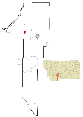
Norris is an unincorporated community and census-designated place in northeastern Madison County, Montana, United States, at the intersection of U.S. Route 287 and Montana Highway 84. As of the 2020 census, the first where it was listed as a CDP, the population was 46.
Amsterdam is a census-designated place (CDP) in Gallatin County, Montana, United States. The population was 206 at the 2020 census. It is part of the Bozeman, MT Micropolitan Statistical Area. It was formerly part of the Amsterdam-Churchill CDP.
Centerville is an unincorporated community and census-designated place (CDP) in Yell County, Arkansas, United States. Centerville is located at the junction of Arkansas Highways 7 and 154, 6.5 miles (10.5 km) north-northeast of Ola. It was first listed as a CDP in the 2020 census with a population of 283.
Swan Lake is a census-designated place and unincorporated community in Lake County, Montana, United States. Its population was 113 as of the 2010 census.
Pioneer Junction is a census-designated place (CDP) in Lincoln County, Montana, United States. The population was 959 at the 2010 census.
Rader Creek is a census-designated place (CDP) in Jefferson County, Montana, United States. The population was 363 at the 2010 census.
Bridger is a census-designated place (CDP) in Gallatin County, Montana, United States. It comprises the Bridger Bowl Ski Area and some nearby residences on the eastern side of the Bridger Range in southwestern Montana. As of the 2010 census the Bridger CDP had a population of 30.
North Harlem Colony is a Hutterite community and census-designated place (CDP) in Blaine County, Montana, United States. It is in the northeast part of the county, half a mile east of Secondary Highway 241 and 4 miles (6 km) north of Harlem and U.S. Route 2. It sits atop a 100-foot-high (30 m) bluff on the east side of Forgey Creek, a southeast-flowing tributary of the Milk River.
Ayers Ranch Colony is a Hutterite community and census-designated place (CDP) in Fergus County, Montana, United States. It is in the southeastern part of the county, on the north side of U.S. Route 87/Montana Highway 200, 8 miles (13 km) west of Grass Range and 24 miles (39 km) east of Lewistown. The North Fork of McDonald Creek runs through the community, part of the Musselshell River watershed leading to the Missouri River.
Surprise Creek Colony is a Hutterite community and census-designated place (CDP) in Judith Basin County, Montana, United States. It is in the north-central part of the county, in the valley of Surprise Creek, a north-flowing tributary of Arrow Creek, which continues northeast to the Missouri River.
Windham is a census-designated place (CDP) in Judith Basin County, Montana, United States. It is in the center of the county along U.S. Route 87, Montana Highway 200 and 3. The town is 6 miles (10 km) southeast of Stanford, the county seat, and 38 miles (61 km) west of Lewistown.

Gilman is an unincorporated community and census-designated place (CDP) in Lewis and Clark County, Montana, United States. It is near the northern border of the county, on the east side of U.S. Route 287. Augusta is less than 2 miles (3 km) to the southwest. US-287 leads northeast from Gilman 24 miles (39 km) to Choteau and south through Augusta 40 miles (64 km) to Interstate 15 near Wolf Creek. Montana Highway 21 forms the southern edge of Gilman and leads east 21 miles (34 km) to Simms.
Twin Creeks is an unincorporated community and census-designated place (CDP) in Missoula County, Montana, United States. As of the 2020 census, it had a population of 164.
Pine Creek is an unincorporated community and census-designated place (CDP) in Park County, Montana, United States. It is in the central part of the county, on the east side of the Paradise Valley, where Pine Creek joins the Yellowstone River.
Sleeping Buffalo is a census-designated place (CDP) in Phillips County, Montana, United States. It is in the eastern part of the county on Secondary Highway 243, 1.5 miles (2.4 km) north of the Sleeping Buffalo Rock historic site on U.S. Route 2. Via US-2, it is a further 10 miles (16 km) east to Saco and 18 miles (29 km) southwest to Malta, the Phillips county seat. The Sleeping Buffalo CDP is on high ground between Nelson Reservoir to the north and the valley of Beaver Creek to the south.


