
Layton is an unincorporated community and census-designated place (CDP) located within Sandyston Township in Sussex County, in the U.S. state of New Jersey. The area is served as United States Postal Service ZIP Code 07851.
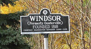
Windsor is a small historic unincorporated community and census-designated place (CDP) located within Robbinsville Township in Mercer County, in the U.S. state of New Jersey. The area is served as United States Postal Service ZIP Code 08561. As of the 2020 United States census, the CDP's population was 330, an increase of 104 (+46.0%) above the 226 counted at the 2010 census. The community, covering 570 acres (230 ha), was added to the National Register of Historic Places in 1992.
Condon is an unincorporated community and census-designated place in Missoula County, Montana, United States. Located along the Swan River and Montana Highway 83, Condon is situated between the Swan Range to the east and the Mission Mountains to the west, providing ready access to the Bob Marshall Wilderness and Mission Mountains Wilderness, respectively. Its population was 285 as of the 2020 United States census, down from 343 in 2010.

Centerville is a census-designated place (CDP) in Linn County, Kansas, United States. As of the 2020 census, the population was 78. It is located 8.5 miles (13.7 km) north of the city of Blue Mound.
Acton is an Census Designated Place in northwestern Yellowstone County, Montana, United States. It has a postal ZIP code (59002) and lies along Montana Highway 3 northwest of the city of Billings, the county seat of Yellowstone County.
Turner is a Census-designated place village in Blaine County, Montana, United States. Turner is located on Montana State Highway 241, 41.5 miles (66.8 km) east-northeast of Chinook. It is 12 miles south of the Canadian border. Its population was 61 as of the 2010 census.
Zortman is a census-designated place and unincorporated community in Phillips County, Montana, United States. Its population was 69 as of the 2010 census. Zortman has a post office with ZIP code 59546.
Pray is a census-designated place and unincorporated community in Park County, Montana, United States, in the Paradise Valley. The town was founded in 1907 by Valentine Eggar, an entrepreneur. He named it after Congressman Charles Nelson Pray. Its population was 681 as of the 2010 census. Pray has a post office with ZIP code 59065, which opened on December 8, 1909.
Shawmut is a census-designated place and unincorporated community in Wheatland County, Montana, United States. Its population was 42 as of the 2010 census. Shawmut has a post office with ZIP code 59078, which opened on October 27, 1885. The community is located along U.S. Route 12 and Montana Highway 3.
Springdale is a census-designated place and unincorporated community in Park County, Montana, United States. Its population was 42 at the 2010 census. The community is located near Interstate 90 and the Yellowstone River. Springdale has its own ZIP code, 59082.
Crane is a census-designated place and unincorporated community in Richland County, Montana, United States. Its population was 102 according to the 2010 census. Crane has a post office with the ZIP code 59217. Montana Highway 16 passes through Crane.
Whitewater is a census-designated place and unincorporated community in Phillips County, Montana, United States. Its population was 64 as of the 2010 census. Whitewater has a post office with ZIP code 59544.
Brady is a census-designated place and unincorporated community in Pondera County, Montana, United States. Its population was 140 as of the 2010 census. Brady has a post office with ZIP code 59416. The community is located along Interstate 15.
Dupuyer is a census-designated place and unincorporated community in Pondera County, Montana, United States. Its population was 86 as of the 2010 census. The community is located along U.S. Route 89 and Dupuyer Creek. Dupuyer has a post office with ZIP code 59432.
Sand Coulee is a census-designated place and unincorporated community in Cascade County, Montana, United States. Its population was 212 as of the 2010 census.
Kila is a census-designated place and unincorporated community in Flathead County, Montana, United States. Its population was 424 as of the 2020 census. Kila has a post office with ZIP code 59920, which opened on May 27, 1901. The community is located along U.S. Route 2, 10 miles from Kalispell.
Marion is a census-designated place and unincorporated community in Flathead County, Montana, United States. Its population was 1,119 as of the 2020 census. Marion has a post office with ZIP code 59925.
Lindsay is an unincorporated hamlet in Dawson County, Montana, United States, located on Montana Highway 200S and the Upper Sevenmile Creek, 22.3 miles (35.9 km) west-northwest of Glendive. The community has a post office with ZIP code 59339, a public school, and a cooperative.
McAllister is an unincorporated community and census-designated place in Madison County, Montana, United States. As of the 2020 census, it had a population of 278. McAllister is located on U.S. Route 287, 6 miles (10 km) north of Ennis. The community has a post office with ZIP code 59740.
Silver Star is an unincorporated community and census-designated place in Madison County, Montana, United States. As of the 2020 census, it had a population of 46. It is located on Montana Highway 41, 10 miles (16 km) north-northeast of Twin Bridges and 16 miles (26 km) southwest of Whitehall. The community has a post office with ZIP code 59751.


