Sun Prairie, Montana

Last updated

Sun Prairie, Montana
CDP
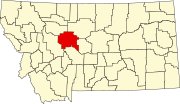
Cascade County Montana Incorporated and Unincorporated areas Sun Prairie Highlighted.svg
Location of Sun Prairie, Montana
Coordinates: 47°32′33″N111°29′24″W / 47.54250°N 111.49000°W / 47.54250; -111.49000
Country United States
State Montana
County Cascade
Area
[1]
  Total5.42 sq mi (14.03 km2)
  Land5.30 sq mi (13.72 km2)
  Water0.12 sq mi (0.31 km2)
Elevation
3,340 ft (1,018 m)
Population
 (2020)
  Total1,615
  Density304.89/sq mi (117.72/km2)
Time zone UTC-7 (Mountain (MST))
  Summer (DST) UTC-6 (MDT)
Area code 406
FIPS code 30-72380
GNIS feature ID1867343

Sun Prairie is a census-designated place (CDP) in Cascade County, Montana, United States. The population was 1,630 at the 2010 census. [2] It is part of the Great Falls Metropolitan Statistical Area and may have evolved as a remote suburb of Great Falls.

Contents

This Sun Prairie should not be confused with the longstanding tiny rural hamlet of Sun Prairie in southern Phillips County, Montana.

Geography

Sun Prairie is located at 47°32′33″N111°29′24″W / 47.54250°N 111.49000°W / 47.54250; -111.49000 (47.542427, -111.490057). [3] Located on Interstate 15, the Sun River flows south of town.

According to the United States Census Bureau, the CDP has a total area of 5.4 square miles (14.0 km2), of which 5.3 square miles (13.8 km2) is land and 0.08 square miles (0.2 km2), or 1.75%, is water. [4]

Demographics

Historical population
CensusPop.Note
2020 1,615
U.S. Decennial Census [5]

As of the census [6] of 2000, there were 1,772 people, 626 households, and 503 families residing in the CDP. The population density was 297.5 inhabitants per square mile (114.9/km2). There were 656 housing units at an average density of 110.1 per square mile (42.5/km2). The racial makeup of the CDP was 91.59% White, 0.45% African American, 4.57% Native American, 0.73% Asian, 0.11% from other races, and 2.54% from two or more races. Hispanic or Latino of any race were 1.52% of the population.

There were 626 households, out of which 39.8% had children under the age of 18 living with them, 65.7% were married couples living together, 9.7% had a female householder with no husband present, and 19.5% were non-families. 14.4% of all households were made up of individuals, and 2.7% had someone living alone who was 65 years of age or older. The average household size was 2.83 and the average family size was 3.15.

In the CDP, the population was spread out, with 31.0% under the age of 18, 5.8% from 18 to 24, 30.6% from 25 to 44, 24.7% from 45 to 64, and 8.0% who were 65 years of age or older. The median age was 35 years. For every 100 females, there were 108.0 males. For every 100 females age 18 and over, there were 101.5 males.

The median income for a household in the CDP was $42,353, and the median income for a family was $44,286. Males had a median income of $34,271 versus $20,833 for females. The per capita income for the CDP was $15,685. About 15.1% of families and 13.9% of the population were below the poverty line, including 18.9% of those under age 18 and 4.1% of those age 65 or over.

Related Research Articles

<span class="mw-page-title-main">Sun Lakes, Arizona</span> CDP in Maricopa County, Arizona

Sun Lakes is an unincorporated community and census-designated place (CDP) in Maricopa County, Arizona, United States. The population was 14,868 at the 2020 census. Sun Lakes is an active adult community comprising five country club communities in three homeowner associations. These include the gated communities of Oakwood and IronWood (IronOaks), the gated and non-gated communities of Palo Verde and Cottonwood, and the non-gated community of Sun Lakes 1. Sun Lakes is a master-planned community developed by Robson Communities.

<span class="mw-page-title-main">Toston, Montana</span> Census-designated place in Montana, United States

Toston is a census-designated place (CDP) in Broadwater County, Montana, United States. The population was 108 at the 2010 census.

<span class="mw-page-title-main">Winston, Montana</span> Census-designated place in Montana, United States

Winston is a census-designated place (CDP) in Broadwater County, Montana, United States. The population was 147 at the 2010 census.

<span class="mw-page-title-main">Black Eagle, Montana</span> CDP in Montana, United States

Black Eagle is a census-designated place (CDP) in Cascade County, Montana, United States. The population was 904 at the 2010 census. It is a suburb of Great Falls.

<span class="mw-page-title-main">Fort Shaw, Montana</span> CDP in Montana, United States

Fort Shaw is a census-designated place (CDP) in Cascade County, Montana, United States. The population was 280 at the 2010 census. Named for a former United States military outpost, it is part of the Great Falls, Montana Metropolitan Statistical Area.

<span class="mw-page-title-main">Simms, Montana</span> CDP in Montana, United States

Simms is a census-designated place (CDP) in Cascade County, Montana, United States. The population was 354 at the 2010 census. It is part of the Great Falls, Montana Metropolitan Statistical Area.

<span class="mw-page-title-main">Sun River, Montana</span> CDP in Montana, United States

Sun River is a census-designated place (CDP) in Cascade County, Montana, United States. The population was 124 at the 2010 census. It is part of the Great Falls, Montana Metropolitan Statistical Area.

<span class="mw-page-title-main">Ulm, Montana</span> CDP in Montana, United States

Ulm is a census-designated place (CDP) in Cascade County, Montana, United States. It was originally a large ranch owned by Indiana-born cattleman William Ulm. The population was 738 at the 2010 census. It is part of the Great Falls, Montana Metropolitan Statistical Area. The Zip Code is 59485.

<span class="mw-page-title-main">Four Corners, Montana</span> Census-designated place in Montana, United States

Four Corners is a census-designated place (CDP) in Gallatin County, Montana, United States. The population was 5,901 at the 2020 census, up from 3,146 in 2010. It is part of the Bozeman, MT Micropolitan Statistical Area.

<span class="mw-page-title-main">Willow Creek, Montana</span> Census-designated place in Gallatin County, Montana, United States.

Willow Creek is a census-designated place (CDP) in Gallatin County, Montana, United States. The population was 210 at the 2010 census. It is part of the Bozeman, MT Micropolitan Statistical Area.

<span class="mw-page-title-main">Big Arm, Montana</span> Census-designated place in Montana, United States

Big Arm is a census-designated place (CDP) in Lake County, Montana, United States. The population was 177 at the 2010 census, up from 131 in 2000.

<span class="mw-page-title-main">Turtle Lake, Montana</span> Census-designated place in Montana, United States

Turtle Lake is a census-designated place (CDP) in Lake County, Montana, United States. The population was 209 at the 2010 census.

<span class="mw-page-title-main">Helena Valley Northeast, Montana</span> Census-designated place in Montana, United States

Helena Valley Northeast is a census-designated place (CDP) in Lewis and Clark County, Montana, United States. The population was 2,995 at the 2010 census. It is part of the Helena Micropolitan Statistical Area.

<span class="mw-page-title-main">Helena Valley Southeast, Montana</span> Census-designated place in Montana, United States

Helena Valley Southeast is a census-designated place (CDP) in Lewis and Clark County, Montana, United States. The population was 8,227 at the 2010 census. It is part of the Helena Micropolitan Statistical Area.

<span class="mw-page-title-main">Riverbend, Montana</span> CDP in Montana, United States

Riverbend is a census-designated place (CDP) in Mineral County, Montana, United States. The population was 442 at the 2000 census. The Zip Code is 59872.

<span class="mw-page-title-main">Greycliff, Montana</span> CDP in Montana, United States

Greycliff is a census-designated place (CDP) in Sweet Grass County, Montana, United States. The population was 56 at the 2000 census.

<span class="mw-page-title-main">Prairie Ridge, Washington</span> CDP in Washington, United States

Prairie Ridge is a census-designated place (CDP) in Pierce County, Washington, United States. The population was 12,288 at the 2020 census.

<span class="mw-page-title-main">Como, Wisconsin</span> CDP in Wisconsin, United States

Como is a census-designated place (CDP) in the town of Geneva, Walworth County, Wisconsin, United States. The population was 2,356 at the 2020 census.

<span class="mw-page-title-main">Niarada, Montana</span> Unincorporated community in Montana, United States

Niarada is a census-designated place (CDP) in Flathead and Sanders counties in Montana, United States. The population was 27 at the 2010 census, down from 50 in 2000.

<span class="mw-page-title-main">Power, Montana</span> CDP in Montana, United States

Power is a census-designated place (CDP) in Teton County, Montana, United States. The population was 171 at the 2000 census. The town is named after Montana pioneer, Thomas Charles Power, who platted the townsite in 1910.

References

  1. "ArcGIS REST Services Directory". United States Census Bureau. Retrieved September 5, 2022.
  2. "Profile of General Population and Housing Characteristics: 2010 Demographic Profile Data (DP-1): Sun Prairie CDP, Montana". United States Census Bureau . Retrieved January 27, 2012.
  3. "US Gazetteer files: 2010, 2000, and 1990". United States Census Bureau. February 12, 2011. Retrieved April 23, 2011.
  4. "Geographic Identifiers: 2010 Demographic Profile Data (G001): Sun Prairie CDP, Montana". United States Census Bureau . Retrieved January 27, 2012.
  5. "Census of Population and Housing". Census.gov. Retrieved June 4, 2016.
  6. "U.S. Census website". United States Census Bureau . Retrieved January 31, 2008.