North Western Coal and Navigation Company

Last updated
North Western Coal and Navigation Company
Type Public
Industry Rail transport Coal mining
Founded1882;141 years ago (1882)
Headquarters,
Canada
Area served
Canada
Contiguous United States
Key people
Sir Alexander Tilloch Galt (Founder), William Stafford (superintendent)

The North Western Coal and Navigation Company, also known as Alberta Railway and Coal Company or Alberta Railway and Irrigation Company, was a coal mining company formed in London, England in 1882 by Sir Alexander Tilloch Galt, one of Canada's Fathers of Confederation. As part of his vision for Canada, Galt was committed to finding industries that would bring settlers to the District of Alberta of the Northwest Territories. The company was founded to create a coal mining industry that could bring settlers to the Northwest Territories. It was based in Lethbridge, Alberta, with his son Elliott Torrance Galt, managing day-to-day operations. The company's superintendent was William Stafford. Money for this company came from a consortium of investors from Canada, England, and the United States.

Contents

Galts' narrow gauge railway
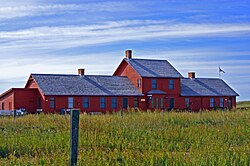
Galt International Depot, originally at Coutts, AB/Sweetgrass, MT border crossing, the depot was moved in 1999 to the Galt Historic Railway Park at Stirling, Alberta. Galt Historic Railway Park; Stirling, AB.jpg
Galt International Depot, originally at Coutts, AB/Sweetgrass, MT border crossing, the depot was moved in 1999 to the Galt Historic Railway Park at Stirling, Alberta.

NWC&NC built the steamboat 'Baroness' along with a number of barges in 1883 to ship coal to Medicine Hat, by the Oldman River. However, this soon proved to be impractical, as the time of navigable high water was short and undependable, and shoals and sandbanks proved hazardous. Only 3200 tons of coal was delivered to Medicine Hat in two years. Sir Alexander Galt had already conceived the idea of a narrow gauge railway, and in 1884 the Federal government confirmed the British charter, and empowered the NWC&NC to build a 3 ft (914 mm) narrow gauge railway from Dunmore, Alberta, to its coal properties at Lethbridge. NWC&NC contracted Canadian Pacific Railway to buy a minimum of 20,000 tons of coal a year for five years at $5 a ton delivered to Medicine Hat. Canada's Governor General, the Marquis of Landsdowne, demonstrated the Dominion government's support of the Galt enterprises, by opening the Galts' narrow gauge railway on October 19, 1885, in Lethbridge. [1] [2]

Alberta Railway & Coal Company

Alberta Railway & Coal Company
Overview
Locale Lethbridge, Alberta to Great Falls, Montana
Dates of operation18891912
Technical
Track gauge 1,435 mm (4 ft 8+12 in) standard gauge

In 1889, the Alberta Railway & Coal Company was incorporated by NWC&NC to build a 3 ft (914 mm) narrow gauge railway from Lethbridge to the Canada–United States border, a distance of 65 miles. Coincident with the building of the AR&CC line in 1890, the Galts received a Montana charter for the narrow gauge Great Falls and Canada Railway (GF&CR). The 3 ft (914 mm) line ran from Sweetgrass, opposite Coutts, to Great Falls, Montana. By extending their railway into the United States, the Galts were able to enlarge the market for Lethbridge coal. In 1901, the GF&CR line was converted to standard gauge, and was purchased by the Montana Great Northern Railway, a subsidiary of the Great Northern Railway (U.S.).

Originally leased to the CPR in 1893, the line from Dunmore to Lethbridge (the AR&CC had acquired the properties of the NWC&NC in 1891), the line was upgraded to standard gauge, and was purchased outright in 1897 and became the first leg of the Crow's Nest Pass branch railway to the CPR's mineral properties in the Kootenay area of south-eastern British Columbia, with the right to extend the line to Hope.

Alberta Railway & Irrigation Company

Construction of the Lethbridge Northern Irrigation District flume across the Oldman River Reconstruction And Repair On The (A. R. and I.) Alberta Railway And Irrigation and (LNID) Lethbridge Northern Irrigation District Irrigation Systems (3498681055).jpg
Construction of the Lethbridge Northern Irrigation District flume across the Oldman River

To further the AR&CC's aims to develop the granted land and attract settlement, Elliott Galt was made aware that farming, not ranching, was the appropriate means of development, and Irrigation was the key. He was approached by Charles Ora Card of the Utah-based Church of Christ (Latter Day Saints), familiarly known as Mormons, who detailed his vision of using the local river systems for irrigation. Card had visited Canada in 1886 and had returned in 1887 with a group that settled on Lees Creek and established the village of Cardston, Alberta. Under Brigham Young, the Mormons had established a thriving community centered on Salt Lake City and had pioneered and gained expertise in farming by irrigation in an area of deficient rainfall.

An agreement was reached with the Mormons in 1891, whereby they would lease 700,000 acres of land, bring in settlers, and provide labour for building the canal system. Economic depression and the lack of capital ended the project. Though temporarily thwarted the Galts continued to pursue their plan for irrigation and soon afterwards, with an upturn in the economy and a new Liberal Party of Canada, government with Clifford Sifton, as Minister of the Department of the Interior, who pursued a vigorous policy of Immigration, the fortunes of the Galt enterprises changed for the better. An agreement was reached with the Government of Canada, whereby in an exchange of lands the AR&CC was able to assemble a solid block of 500,000 acres adjacent to the St. Mary River thus making large-scale irrigation feasible. A new contract was signed with the Mormons in which they were to construct the canal system and in return for their labour they were to be paid "one-half in cash and one-half in land, the land with water rights being valued at three dollars per acre, to a total of $75,000 and 25,000 acres. A remission of the survey fee of ten cents per acre was also granted by the government. The church-sponsored immigrants, to whom Galt advanced the costs of transportation, were to establish themselves in hamlet, one each in the tracts twenty and thirty miles south of Lethbridge, the communities of Stirling & Magrath, Alberta were established in 1889 as per contract with AR&IC. The main canal was completed in August 1900.

That same year the St. Mary’s River Railway Company was incorporated to provide access and serve the settlers benefiting from the irrigation system. It reached Cardston in 1903, with permission to extend the 3 ft (914 mm) narrow gauge line. At Raymond, Alberta a sugar beet factory was erected. A further consolidation of land took place in 1900, followed in 1902 by the purchase of the adjacent 500,000 Acre Tract at one dollar an acre after the awarding of credits amounting to two dollars an acre. Payment was to be made in ten equal annual installments. The stipulation was that the land could not be sold for more than five dollars an acre, and the unsold balance, after 15 years, would revert to the government. In 1904 the Galt companies were merged into a new corporation, the Alberta Railway and Irrigation Company (AR&IC). The St. Mary's Canal was enlarged and a beginning was made on a canal from the Milk River, halted by the Boundary Waters Treaty of 1909 between the United States and Canada, dividing the waters of the two rivers equally between the two countries. In 1912 the Canadian Pacific Railway leased the AR&IC for 999 years thus ending the independence of the Galt enterprise.

See also

Related Research Articles

<span class="mw-page-title-main">Alexander Tilloch Galt</span> Canadian politician

Sir Alexander Tilloch Galt, was a politician and Founding Father of the Canadian Confederation.

<span class="mw-page-title-main">St. Mary River (Alberta–Montana)</span> River in Montana, United States and Canada

The Saint Mary River is a cross-border tributary of the Oldman River, itself a tributary of the South Saskatchewan River. The Saint Mary together with the Belly River and Waterton River drains a small portion of Montana, in the United States, to the Hudson Bay watershed in Canada.

<span class="mw-page-title-main">Magrath, Alberta</span> Town in Alberta, Canada

Magrath is a town in Cardston County, Alberta, Canada. Its population was 3,281 in 2022. Magrath is 32 km (20 mi) south of Lethbridge and 242 km (150 mi) south of Calgary.

<span class="mw-page-title-main">Charles Alexander Magrath</span> Canadian politician

Charles Alexander Magrath was a Canadian land surveyor and statesman. He conducted foundation surveys of the North-West Territories (NWT) from 1878 until 1885. He joined Sir Alexander Tilloch Galt and Elliott Torrance Galt in their western industrial enterprises as a surveyor, later becoming Elliott's assistant and Land Commissioner of the North Western Coal and Navigation Company. He was also the first mayor of Lethbridge, Alberta District, NWT, which has a major street named after him.

<span class="mw-page-title-main">Montague Aldous</span>

Montague Aldous was a Dominion Topographical Surveyor from Charlottetown, Prince Edward Island. He was a participant in foundation surveys of the Northwest Territories. He was associated with A.L. Russell in 1877 in a survey west to the third meridian. Taken on Special Survey in 1879, he surveyed the fourth meridian to a point north of Lloydminster, Alberta/Saskatchewan, then ran in the 14th base line west to Stony Plain where it intersected the 5th meridian. His assistant, Charles Alexander Magrath, was later the first mayor of Lethbridge, Northwest Territories. In 1880 Aldous surveyed the fifth meridian south to Waterton Lakes. He spent the rest of the summer in southern Alberta's Porcupine Hills, then being taken up for ranching.

<span class="mw-page-title-main">Stirling, Alberta</span> Village in Alberta, Canada

Stirling is a village in southern Alberta, Canada that is surrounded by the County of Warner No. 5. The village is located on Highway 4, approximately 31 km (19 mi) southeast of Lethbridge and 72 km (45 mi) northwest of the Canada–US border.

<span class="mw-page-title-main">Charles Ora Card</span> Canadian Mormon leader

Charles Ora Card was the American founder of Cardston, Alberta, the first Mormon settlement in Canada. He has been referred to as "Canada's Brigham Young". Card was a Mormon pioneer as a teenager, traveling from the eastern United States to Utah Territory in the 1850s. After arriving in Utah, he supervised the construction of the Logan Utah Temple, served as a city councilman, and was appointed to the first board of trustees of Brigham Young College. Card was then tasked by leaders in the LDS Church to travel north to Canada and establish a Latter-day Saint colony there. He worked to make the community self-sufficient, participating in irrigation projects. Card was a practitioner of plural marriage, marrying a total of four wives and having sixteen children. He served in leadership positions within the LDS Church, mainly as stake president. He was the spiritual and economic leader of Cardston.

<span class="mw-page-title-main">William Lethbridge</span>

William Lethbridge (1825–1901) was a lawyer in England. When bookseller W H Smith owner William Henry Smith II decided to become involved in politics in 1864, he enlisted Lethbridge as a managing partner. He sat for a portrait by Frederick Sandys (1829-1904) in 1882.

<span class="mw-page-title-main">History of Lethbridge</span>

The modern history of Lethbridge extends to the mid-19th century, when the area was developed from drift mines opened by Nicholas Sheran in 1874, and the North Western Coal and Navigation Company in 1882. Prior to the development of drift mines in the area, Lethbridge, Alberta was known as Coal Banks, and was part of the territory of the Blackfoot Confederacy. The Confederacy was made up of the Kainai Nation, the Northern Peigan, the Southern Peigan (Blackfeet), and the Siksika Nation.

Hays is a hamlet in southern Alberta, Canada within the Municipal District of Taber. It is located at the intersection of Highway 524 and Highway 875 between Vauxhall and Redcliff. The Bow River is 3.3 kilometres (2.1 mi) to the north of the hamlet and the Oldman River is approximately 19 kilometres (12 mi) to the south. These two rivers converge to form the South Saskatchewan River approximately 20 kilometres (12 mi) to the southeast.

<span class="mw-page-title-main">Narrow-gauge railways in Canada</span>

Although most railways of central and eastern Canada were initially built to a 5 ft 6 in broad gauge, there were several, especially in Atlantic Canada and Ontario, which were built as individual narrow-gauge lines. These were generally less expensive to build, but were more vulnerable to frost heaving because vertical displacement of one rail caused greater angular deflection of the narrower two-rail running surface. Most of the longer examples were regauged starting in the 1880s as the railway network began to be bought up by larger companies.

<span class="mw-page-title-main">Stirling Agricultural Village</span> Settlement in Alberta, Canada

Stirling Agricultural Village was designated as a National Historic Site of Canada on June 22, 1989. The site was designated as a national historical site of Canada because it is the best surviving example of a Mormon agricultural village. The Michelsen Farmstead was the focus of the community, and is now a totally restored museum, listed as a Provincial Historic Site in 2001. The Galt Historic Railway Park is another popular museum located in this historic site.

Leavitt is a hamlet in southern Alberta, Canada within Cardston County, located about 13 kilometres (8 mi) west of Cardston on Highway 5. It falls within the Canadian federal electoral district of Medicine Hat—Cardston—Warner.

<span class="mw-page-title-main">Thomas Rowell Leavitt</span> Canadian Mormon and settler (1834–1891)

Thomas Rowell "Tom" Leavitt was an member of the Church of Jesus Christ of Latter-day Saints and the founding settler of Leavitt, Alberta, Canada, which the former Utah sheriff and marshal founded at age 53 after an arduous 800-mile (1,300 km) journey in covered wagons, fleeing a crackdown on polygamy that sent fellow members of The Church of Jesus Christ of Latter-day Saints across the border to Mexico and Canada.

Craddock is a former unincorporated community in southern Alberta, Canada within the County of Warner No. 5. It is located between the Village of Stirling and the Hamlet of New Dayton, approximately 30 kilometres (19 mi) southeast of the City of Lethbridge on Highway 4.

McNab is a former unincorporated community in southern Alberta, Canada within the County of Warner No. 5. It is located on Highway 506 between the Hamlet of New Dayton and the Village of Warner, approximately 50 kilometres (31 mi) southeast of the City of Lethbridge.

<span class="mw-page-title-main">Elliott Torrance Galt</span> Canadian businessman

Elliott Torrance Galt was a Canadian businessman and developer.

<span class="mw-page-title-main">Mormon Trail (Canada)</span>

Canada's Mormon Trail has a variety of National Historic Sites, Provincial Historic Sites and many points of interest that display the unique cultural heritage the Mormons have had in the settling of Southern Alberta.

<span class="mw-page-title-main">Sweetgrass–Coutts Border Crossing</span> Border crossing between Canada and the United States

The Sweetgrass–Coutts Border Crossing connects the town of Sweet Grass, Montana with the village of Coutts, Alberta, on the Canada–United States border. I-15 on the American side joins Alberta Highway 4 on the Canadian side. Similarly, BNSF Railway and Canadian Pacific Railway (CP) connect. A primary conduit for cross border trade estimated at CA$6 billion, it is the busiest crossing for both the province of Alberta and state of Montana, and among the busiest west of the Great Lakes.

References

  1. Skelton, Oscar (1920). The Life and Times of Alexander Tilloch Galt. Oxford University Press.
  2. Harris, Jane (2006). Stars Appearing: The Galts Vision of Canada. Kitchener: Volumes Publishing. ISBN   978-0-9780985-0-6.