Hungry Horse, Montana

Last updated
Hungry Horse, Montana
Hungry Horse Montana Panorama looking east on US2.jpg
Looking east at Hungry Horse Montana on U.S. Route 2
Flathead County Montana Incorporated and Unincorporated areas Hungry Horse Highlighted.svg
Location of Hungry Horse, Montana
Coordinates: 48°23′5″N114°3′53″W / 48.38472°N 114.06472°W / 48.38472; -114.06472 Coordinates: 48°23′5″N114°3′53″W / 48.38472°N 114.06472°W / 48.38472; -114.06472
Country United States
State Montana
County Flathead
Area
[1]
  Total1.52 sq mi (3.94 km2)
  Land1.43 sq mi (3.71 km2)
  Water0.09 sq mi (0.23 km2)
Elevation
[2]
3,097 ft (944 m)
Population
 (2020)
  Total828
  Density577.41/sq mi (222.99/km2)
Time zone UTC-7 (Mountain (MST))
  Summer (DST) UTC-6 (MDT)
ZIP code
59919
Area code 406
FIPS code 30-38125
GNIS feature ID0785162 [2]

Hungry Horse is an unincorporated community and census-designated place (CDP) in Flathead County, Montana, United States. The population was 828 at the 2020 census. [3] The ZIP code for Hungry Horse is 59919.

Contents

History

The town sprang up during the construction of Hungry Horse Dam when the U.S. Bureau of Reclamation placed more than one hundred prefabricated buildings at the site to house workers. [4] In 1948, Flathead County commissioners changed the name of the newly formed "Damtown" to Hungry Horse. [5] The name comes from a local legend about two horses, Tex and Jerry, that escaped and almost starved to death in deep snow along the South Fork of the Flathead River. [6]

Geography

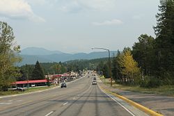
Hungry Horse is located in central Flathead County at 48°23′5″N114°3′53″W / 48.38472°N 114.06472°W / 48.38472; -114.06472 (48.384609, -114.064849), [7] at the confluence of the Flathead River and its South Fork. Bad Rock Canyon lies less than one mile to the west of Hungry Horse.

U.S. Route 2 passes through Hungry Horse, leading northeast 10 miles (16 km) to West Glacier and southwest 23 miles (37 km) to Kalispell. West Side Road leads southeast from town up the South Fork valley 4 miles (6 km) to Hungry Horse Dam and its reservoir.

According to the United States Census Bureau, the Hungry Horse CDP has a total area of 1.5 square miles (3.8 km2), of which 1.4 square miles (3.7 km2) is land and 0.04 square miles (0.1 km2), or 3.61%, is water. [8]

Demographics

Historical population
CensusPop.Note
2020 828
U.S. Decennial Census [3]
Hungry Horse Volunteer Fire Department Hungry Horse Volunteer Fire Department.jpg
Hungry Horse Volunteer Fire Department

As of the census [9] of 2000, there were 934 people, 346 households, and 237 families residing in the CDP. The population density was 506.0 inhabitants per square mile (195.4/km2). There were 404 housing units at an average density of 218.9 per square mile (84.5/km2). The racial makeup of the CDP was 94.86% White, 2.14% Native American, 0.11% Asian, 0.43% Pacific Islander, 0.43% from other races, and 2.03% from two or more races. Hispanic or Latino of any race were 1.71% of the population.

There were 346 households, out of which 37.0% had children under the age of 18 living with them, 50.6% were married couples living together, 11.0% had a female householder with no husband present, and 31.5% were non-families. 24.3% of all households were made up of individuals, and 4.9% had someone living alone who was 65 years of age or older. The average household size was 2.70 and the average family size was 3.20.

In the CDP, the population was spread out, with 30.3% under the age of 18, 7.9% from 18 to 24, 31.3% from 25 to 44, 23.7% from 45 to 64, and 6.9% who were 65 years of age or older. The median age was 35 years. For every 100 females, there were 108.5 males. For every 100 females age 18 and over, there were 115.6 males.

The median income for a household in the CDP was $26,550, and the median income for a family was $28,523. Males had a median income of $30,197 versus $16,607 for females. The per capita income for the CDP was $10,530. About 18.1% of families and 29.7% of the population were below the poverty line, including 38.3% of those under age 18 and 19.8% of those age 65 or over.

In 2010, the census reported 826 people. [10]

Points of interest

Notable people

Related Research Articles

<span class="mw-page-title-main">Flathead County, Montana</span> County in Montana, United States

Flathead County is in the U.S. state of Montana. At the 2020 census, its population was 104,357, making it the state's fourth most populous county. Its county seat is Kalispell. Its numerical designation is 7. Its northern border is on the state's north border, making it contiguous with the Canada–US border, facing British Columbia.

<span class="mw-page-title-main">Bigfork, Montana</span> Unincorporated community in Montana, United States

Bigfork is a census-designated place (CDP) in Flathead County, Montana, United States. It is within Montana's Rocky Mountains. The population was 4,270 at the 2010 census, up from 1,421 in 2000.

<span class="mw-page-title-main">Coram, Montana</span> Unincorporated community in Montana, United States

Coram is an unincorporated community and census-designated place (CDP) in Flathead County, Montana, United States. The population was 539 in 2010, up from 337 at the 2000 census. Coram lies 7 miles (11 km) southwest of the western entrance of Glacier National Park.

<span class="mw-page-title-main">Lakeside, Montana</span> Unincorporated community in Montana, United States

Lakeside is an unincorporated area and census-designated place (CDP) in Flathead County, Montana, United States. The population was 2,669 at the 2010 census, up from 1,679 in 2000.

<span class="mw-page-title-main">Martin City, Montana</span> Unincorporated community in Montana, United States

Martin City is an unincorporated community and census-designated place (CDP) in Flathead County, Montana, United States. As of the 2010 census, it had a population of 500, up from 331 in 2000.

<span class="mw-page-title-main">Somers, Montana</span> Unincorporated community in Montana, United States

Somers is an unincorporated community and census-designated place (CDP) in Flathead County, Montana, United States. The population was 1,109 at the 2010 census, up from 556 in 2000.

<span class="mw-page-title-main">Big Arm, Montana</span> Census-designated place in Montana, United States

Big Arm is a census-designated place (CDP) in Lake County, Montana, United States. The population was 177 at the 2010 census, up from 131 in 2000.

<span class="mw-page-title-main">Elmo, Montana</span> Census-designated place in Montana, United States

Elmo is a census-designated place (CDP) in Lake County, Montana, United States. The population was 180 at the 2010 census, up from 143 in 2000.

<span class="mw-page-title-main">Finley Point, Montana</span> Census-designated place in Montana, United States

Finley Point is a census-designated place (CDP) in Lake County, Montana, United States. As of the 2010 census the population was 480.

<span class="mw-page-title-main">Rocky Point, Montana</span> Census-designated place in Montana, United States

Rocky Point is a census-designated place (CDP) in Lake County, Montana, United States. The population was 97 at the 2010 census.

<span class="mw-page-title-main">Rollins, Montana</span> Census-designated place in Montana, United States

Rollins is an unincorporated community and census-designated place (CDP) in Lake County, Montana, United States. The population was 209 at the 2010 census, up from 183 in 2000.

<span class="mw-page-title-main">Woods Bay, Montana</span> Census-designated place in Montana, United States

Woods Bay is a census-designated place (CDP) in Lake County, Montana, United States. The population was 661 at the 2010 census, down from 748 at the 2000 census.

<span class="mw-page-title-main">Evaro, Montana</span> CDP in Montana, United States

Evaro is a census-designated place (CDP) in Missoula County, Montana, United States, and part of the Missoula Metropolitan Statistical Area. It is located on the southernmost tip of the Flathead Indian Reservation, approximately 12 miles (19 km) north of downtown Missoula and is served by US Highway 93. In 2010, Evaro had a population of 322, a decrease from 329 in 2000.

<span class="mw-page-title-main">Dixon, Montana</span> CDP in Montana, United States

Dixon is a census-designated place (CDP) in Sanders County, Montana, United States. The population was 216 at the 2000 census.

<span class="mw-page-title-main">Lonepine, Montana</span> CDP in Montana, United States

Lonepine is a census-designated place (CDP) in Sanders County, Montana, United States. The population was 137 at the 2000 census.

<span class="mw-page-title-main">Paradise, Montana</span> CDP in Montana, United States

Paradise is a census-designated place (CDP) in Sanders County, Montana, United States. The population was 166 at the 2020 census.

<span class="mw-page-title-main">Arlee, Montana</span> Census-designated place in Montana, United States

Arlee is an unincorporated community and census-designated place (CDP) in Lake County, Montana, United States. The population was 636 at the 2010 census. It is named after Alee, a Salish chief. The chief's name has no "r", as the Salish alphabet has no letter "r".

<span class="mw-page-title-main">Dayton, Montana</span> Census-designated place in Montana, United States

Dayton is an unincorporated community and census-designated place (CDP) in Lake County, Montana, United States. The population was 84 at the 2010 census.

<span class="mw-page-title-main">Jette, Montana</span> Census-designated place in Montana, United States

Jette is a census-designated place (CDP) in Lake County, Montana, United States. The population was 253 at the 2010 census.

<span class="mw-page-title-main">Niarada, Montana</span> Unincorporated community in Montana, United States

Niarada is a census-designated place (CDP) in Flathead and Sanders counties in Montana, United States. The population was 27 at the 2010 census, down from 50 in 2000.

References

  1. "ArcGIS REST Services Directory". United States Census Bureau. Retrieved September 5, 2022.
  2. 1 2 U.S. Geological Survey Geographic Names Information System: Hungry Horse, Montana
  3. 1 2 "Census of Population and Housing". Census.gov. Retrieved June 4, 2016.
  4. Aarstad, Rich; Arguimbau, Ellie; Baumler, Ellen; Porsild, Charlene; Shovers, Brian (2009). Montana place names from Alzada to Zortman. Helena: Montana Historical Society Press. p. 127. ISBN   9780975919613.
  5. Roise, Charlene (Summer 2018). "A Mid-Century Monolith in Northwestern Montana: The Hungry Horse Dam Project". Montana The Magazine of Western History. 68 (2): 49.
  6. "Geographic names". Forest History Society. Archived from the original on 18 June 2019. Retrieved 3 July 2019.
  7. "US Gazetteer files: 2010, 2000, and 1990". United States Census Bureau. 2011-02-12. Retrieved 2011-04-23.
  8. "Geographic Identifiers: 2010 Census Summary File 1 (G001), Hungry Horse CDP, Montana". American FactFinder. U.S. Census Bureau. Archived from the original on February 13, 2020. Retrieved June 7, 2016.
  9. "U.S. Census website". United States Census Bureau . Retrieved 2008-01-31.
  10. United States Census Bureau: 2010 Population Finder. 2010 Demographic Profile: MT - Hungry Horse CDP. 6 August 2013.