
Glacier County is located in the U.S. state of Montana. As of the 2020 census, the population was 13,778. The county is located in northwestern Montana between the Great Plains and the Rocky Mountains, known to the Blackfeet as the "Backbone of the World". The county is geographically and culturally diverse and includes the Blackfeet Indian Reservation, Glacier National Park, and Lewis and Clark National Forest. The county is bordered by 75 miles of international boundary with two ports of entry open year-round and one seasonal international border crossing into Alberta, Canada.
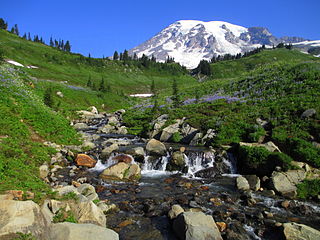
Mount Rainier National Park is a national park of the United States located in southeast Pierce County and northeast Lewis County in Washington state. The park was established on March 2, 1899, as the fourth national park in the United States, preserving 236,381 acres including all of Mount Rainier, a 14,410-foot (4,390 m) stratovolcano. The mountain rises abruptly from the surrounding land with elevations in the park ranging from 1,600 feet to over 14,000 feet (490–4,300 m). The highest point in the Cascade Range, Mount Rainier is surrounded by valleys, waterfalls, subalpine meadows, and 91,000 acres of old-growth forest. More than 25 glaciers descend the flanks of the volcano, which is often shrouded in clouds that dump enormous amounts of rain and snow.

Glacier National Park is a national park of the United States located in northwestern Montana, on the Canada–United States border. The park encompasses more than 1 million acres (4,100 km2) and includes parts of two mountain ranges, more than 130 named lakes, more than 1,000 different species of plants, and hundreds of species of animals. This vast pristine ecosystem is the centerpiece of what has been referred to as the "Crown of the Continent Ecosystem", a region of protected land encompassing 16,000 sq mi (41,000 km2).

Denali National Park and Preserve, formerly known as Mount McKinley National Park, is a United States national park and preserve located in Interior Alaska, centered on Denali, the highest mountain in North America. The park and contiguous preserve encompass 6,045,153 acres which is larger than the state of New Hampshire. On December 2, 1980, 2,146,580-acre Denali Wilderness was established within the park. Denali's landscape is a mix of forest at the lowest elevations, including deciduous taiga, with tundra at middle elevations, and glaciers, snow, and bare rock at the highest elevations. The longest glacier is the Kahiltna Glacier. Wintertime activities include dog sledding, cross-country skiing, and snowmobiling. The park received 594,660 recreational visitors in 2018.

Lake Cushman is a 4,014.6-acre (16.247 km2) lake and reservoir on the north fork of the Skokomish River in Mason County, Washington. The lake originally was a long narrow broadening of the Skokomish River formed in a glacial trough and dammed by a terminal moraine from the Vashon Glaciation during the most recent ice age.

Lake McDonald is the largest lake in Glacier National Park. It is located at 48°35′N113°55′W in Flathead County in the U.S. state of Montana. Lake McDonald is approximately 10 miles (16 km) long, and over a mile (1.6 km) wide and 472 feet deep, filling a valley formed by a combination of erosion and glacial activity. Lake McDonald lies at an elevation of 3,153 feet (961 m) and is on the west side of the Continental Divide. Going-to-the-Sun Road parallels the lake along its southern shoreline. The surface area of the lake is 6,823 acres (27.6 km2).

The Lake McDonald Lodge is a historic lodge located within Glacier National Park, on the southeast shore of Lake McDonald. The lodge is a 3+1⁄2-story structure built in 1913 based on Kirtland Cutter's design. The foundation and first floor walls are built of stone, with a wood-frame superstructure. The lobby is a large, open space that extends to the third story. It has a massive fireplace and a concrete floor scored in a flagstone pattern, with messages in several Indian languages inscribed into it. The rustic lodge was designated a National Historic Landmark in 1987 as one of the nation's finest examples of large-scale Swiss chalet architecture. Lake McDonald Lodge is a member of Historic Hotels of America, the official program of the National Trust for Historic Preservation.

Bowman Lake is in the northwestern portion of Glacier National Park in Montana. The lake is accessed via a 6 miles (9.7 km) unpaved road from the small town of Polebridge. At 1,706 acres (690 ha), Bowman Lake is the third largest lake in the park, after Lake McDonald and Saint Mary Lake.

Sperry Glacier is a glacier on the north slopes of Gunsight Mountain west of the Continental Divide in Glacier National Park in the U.S. state of Montana. Although many geologic features of Glacier National Park were formed during the much longer period of glaciation ending over 10,000 years ago, Sperry Glacier — like all the glaciers in the park today — is a product of the recent Little Ice Age, the period of cooler average temperatures starting in about the 13th century and concluding in the mid-19th century.

The Rising Sun Auto Camp, also known as the Roes Creek Auto Camp, East Glacier Auto Camp or simply Rising Sun preserves a portion of the built-up area of Glacier National Park that documents the second phase of tourist development in the park. Rising Sun is located along the Going-to-the-Sun Road, approximately 7 miles (11 km) from the east entrance to Glacier National Park, Montana, United States. Rising Sun is a wayside area that has a National Park Service campground, a camp store and gift shop, picnic area, restaurant, as well as a motel and guest cabins which are managed by the park's concessionaire, Xanterra Parks & Resorts. In the immediate area, there is also a boat dock as well as sightseeing boats which allow visitors to tour Saint Mary Lake, the second largest lake in the park. "The most popular spot for [Glacier] tourists is Rising Sun, an overlook of Goose Island in St. Mary Lake and one of the most photographed spots in the park."

Bullfrog Basin is one of the National Park Service recreation sites of the Glen Canyon National Recreation Area of Kane County, Utah, United States, adjoining Lake Powell. It encompasses Bullfrog Basin Airport, the Bullfrog Resort and Marina, the Bullfrog terminus of the Charles Hall Ferry, and a campground.

The following articles relate to the history, geography, geology, flora, fauna, structures and recreation in Glacier National Park (U.S.), the U.S. portion of the Waterton-Glacier International Peace Park.

Gull Point State Park is a state park of Iowa, United States, located on West Okoboji Lake in the city of Wahpeton. It is the primary state park unit in the Iowa Great Lakes region. Two areas of the park were listed as nationally recognized historic districts on the National Register of Historic Places in 1990.

The Lake McDonald Lodge Coffee Shop is a visitor services building in the Lake McDonald district of Glacier National Park, Montana. The coffee shop was built in 1965 as part of the National Park Service's Mission 66 program to upgrade visitor facilities, in order to increase visitor dining capacity. Under the Mission 66 projects, visitor facilities were usually comprehensive in nature, providing a range of visitor services. Specialized concession buildings like the Coffee Shop were unusual in Mission 66. It was leased to the Glacier Park Company for operation, in anticipation of the construction of lodging facilities by the company.

Asa Lynn "Ace" Powell was an American painter, sculptor, and etcher of genre scenes and imagery relating to indians, cowboys, horses, and wildlife. His artwork was influenced by that of fellow Montana artist Charles M. Russell. Powell's lifetime body of work consists of between 12,000 and 15,000 artworks. Although he preferred working with oil paints, he also produced a large number of watercolor paintings and drawings, as well as a number of works in bronze, terracotta, and wood.
The Sprague Fire was a wildfire in Glacier National Park in Montana. It was first reported on August 10, 2017, around 8:30 pm after being caused by a lightning storm. The fire encompassed 16,982 acres (6,872 ha). It nearly destroyed the historic Sperry Chalet.
Bull Head Lodge and Studio, located off Going-to-the-Sun Road near Apgar in Flathead County, Montana was listed on the National Register of Historic Places in 1984.

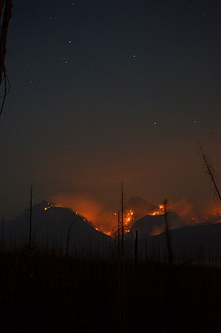
The Howe Ridge Fire was a wildfire in Glacier National Park in the U.S. state of Montana. Ignited by a thunderstorm on the evening of August 11, 2018, the fire was located on the northwest side of Lake McDonald. Several other fires were also started near the park due to the storm. On August 12 National Park Service officials issued a mandatory evacuation of private cabins and federally owned properties including the Lake McDonald Lodge complex which was temporarily closed. On August 13, National Park officials then closed the 32 miles (51 km) of the Going-to-the-Sun Road from Apgar Village to Logan Pass on the west side of the park after "extreme fire conditions" occurred the previous evening, threatening multiple structures. By August 14 the fire had spread to over 2,500 acres (1,000 ha). Though fire fighting conditions had improved by August 14, a preliminary damage assessment stated that at least seven private residences and several other structures belonging to the National Park Service had been consumed by the blaze at the Kelly's Camp Historic District and a number of other park service owned structures at the Wheeler residence. The Lake McDonald Ranger Station was saved by firefighters after its roof had been on fire. Thick haze and smoke obscured the fire on August 15 and while weather conditions remained favorable for fire growth, the haze kept the fire from spreading greatly. Haze and smoke made exact measurements of the amount of acreage burned difficult to determine, however infrared imagery indicated that the fire was 3,500 acres (1,400 ha) by August 16. By August 21 overnight infrared imagery indicated the fire had burned 9,672 acres (3,914 ha). On August 23 the fire had nearly 200 firefighters assigned to it and had burned 10,323 acres (4,178 ha) with only 10 percent of the fire contained. Full containment was not anticipated until November 1st. Fire remained active along the northern flank between Mount Vaught and McDonald Creek as well as the southern margin on the west side of Lake McDonald and had spread to 11,519 acres (4,662 ha) by August 24 and then 12,435 acres (5,032 ha) by August 30. By August 28, cooler temperatures and widespread rain helped to keep the fire from expanding however a trend back to warmer and drier conditions was expected to provide conditions for future fire growth due to heavy fuels and terrain.
Sherwood Lodge, in Glacier National Park near West Glacier, Montana, was built in 1919. It was listed on the National Register of Historic Places in 2008.

Good Spirit Lake is a lake on the eastern side of the Canadian province of Saskatchewan. It is a shallow lake notable for its naturally sandy beaches, parks, and sand dunes. One of Saskatchewan's six founding provincial parks, Good Spirit Lake Provincial Park, surrounds the western and southern shores of the lake. The lake is in the RM of Good Lake No. 274 and Yorkton, 48 kilometres (30 mi) to the south, is the nearest city. The hamlets of Burgis Beach and Canora Beach — the only two communities on the lake — are located on the eastern shore. The southern shore of the lake is accessed from Highway 229 and the northern shore is accessed from Highway 746. Highway 47 runs north to south west of the lake and Good Spirit Lake Provincial Park.


