

The Flathead River Bridge otherwise known as the Red Bridge is an abandoned steel truss bridge located at the south end of 4th Ave in Columbia Falls, Montana. [1] The bridge was added to the National Register of Historic Places in 2010. [2]
The Flathead River Bridge otherwise known as the Red Bridge is an abandoned steel truss bridge located at the south end of 4th Ave in Columbia Falls, Montana. [1] The bridge was added to the National Register of Historic Places in 2010. [2]
Originally a wooden bridge was built on the location in the late 1800s, eventually it was sold to the county. In 1912, a new steel bridge was built only to be nearly swept away by the flood of 1913. [3] The Red Bridge was reinforced and survived the flood in 1964, but was ultimately deemed unsafe for car traffic in 1989 and closed off to the public in 1992. The closure diverted traffic to U.S. Route 2. [4]

Lincoln County is a county located in the U.S. state of Montana. As of the 2020 census, the population was 19,677. Its county seat is Libby. The county was founded in 1909 and named for President Abraham Lincoln. The county lies on Montana's north border and thus shares the US-Canadian border with the Canadian province of British Columbia.

Flathead County is a county located in the U.S. state of Montana. At the 2020 census, its population was 104,357, making it the state's fourth most populous county. Its county seat is Kalispell. Its numerical designation is 7. Its northern border is on the state's north border, making it contiguous with the Canada–US border, facing British Columbia.

Bigfork is a census-designated place (CDP) in Flathead County, Montana, United States. It is within Montana's Rocky Mountains. The population was 5,118 at the 2020 census, up from 4,270 in 2010.
Columbia Falls is a city along the Flathead River in Flathead County, Montana, United States. The population was 5,308 at the 2020 census. Columbia Falls has been ranked as one of the best and safest places to live in Montana.
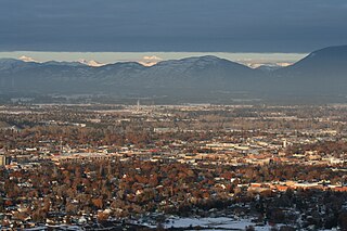
Kalispell is a city in Montana and the county seat of Flathead County, Montana, United States. The 2020 census put Kalispell's population at 24,558. In Montana's northwest region, it is the largest city and the commercial center of the Kalispell Micropolitan Statistical Area. The name Kalispell is a Salish word meaning "flat land above the lake".

Troy is a city in Lincoln County, Montana, United States. The population was 797 at the 2020 census. It lies at the lowest elevation of any settlement in Montana. The town is on U.S. Route 2, near Montana Highway 56, in the Kootenai River gorge by the Kootenai National Forest.

Libby is a city in northwestern Montana, United States and the county seat of Lincoln County. The population was 2,775 at the 2020 census.

The Clark Fork, or the Clark Fork of the Columbia River, is a river in the U.S. states of Montana and Idaho, approximately 310 miles (500 km) long. The largest river by volume in Montana, it drains an extensive region of the Rocky Mountains in western Montana and northern Idaho in the watershed of the Columbia River. The river flows northwest through a long valley at the base of the Cabinet Mountains and empties into Lake Pend Oreille in the Idaho Panhandle. The Pend Oreille River in Idaho, Washington, and British Columbia, Canada which drains the lake to the Columbia in Washington, is sometimes included as part of the Clark Fork, giving it a total length of 479 miles (771 km), with a drainage area of 25,820 square miles (66,900 km2). In its upper 20 miles (32 km) in Montana near Butte, it is known as Silver Bow Creek. Interstate 90 follows much of the upper course of the river from Butte to Saint Regis. The highest point within the river's watershed is Mount Evans at 10,641 feet (3,243 m) in Deer Lodge County, Montana along the Continental Divide.

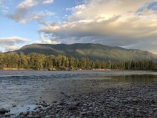
The Flathead River, in the northwestern part of the U.S. state of Montana, originates in the Canadian Rockies to the north of Glacier National Park and flows southwest into Flathead Lake, then after a journey of 158 miles (254 km), empties into the Clark Fork. The river is part of the Columbia River drainage basin, as the Clark Fork is a tributary of the Pend Oreille River, a Columbia River tributary. With a drainage basin extending over 8,795 square miles (22,780 km2) and an average discharge of 11,380 cubic feet per second (322 m3/s), the Flathead is the largest tributary of the Clark Fork and constitutes over half of its flow.

This is a list of properties and historic districts in Montana that are listed on the National Register of Historic Places. The state's more than 1,100 listings are distributed across all of its 56 counties.

State Route 25 (SR 25), named the Coulee Reservoir Highway, is a 121.17-mile-long (195.00 km) state highway serving communities in Lincoln and Stevens counties in the U.S. state of Washington. The highway begins at an intersection with U.S. Route 2 (US 2) east of Davenport and continues northwest to cross the Spokane River. From there, SR 25 parallels the Columbia River and Franklin D. Roosevelt Lake upstream through several small communities, passing the Gifford–Inchelium Ferry, to Kettle Falls. In Kettle Falls, the roadway intersects US 395, co-signed with SR 20 and continues north to Northport, where former SR 251 is intersected and SR 25 crosses the Columbia River on the Northport Bridge. The highway travels northwest to the Canadian border, where it becomes British Columbia Highway 22 (BC 22).
The Flathead Valley is a region located in the northwestern part of the U.S. state of Montana.

The Kettle Falls Bridges is the collective name for a pair of steel cantilever bridges carrying State Route 20/U.S. Route 395 and the Kettle Falls International Railway across the Columbia River at Kettle Falls, Washington. The south bridge carries motor vehicle traffic while the similar northern span is used for rail.
Big Prairie, Montana, el. 3,625 feet (1,105 m), is an open meadow area on the east side of the North Fork of the Flathead River, in Glacier National Park and is a former settlement. It is within Flathead County, Montana. It was settled by at least 19 homesteads in the early 20th century.

The Soldiers' Home Historic District, a historic Old soldiers' home campus, is located in Columbia Falls, Flathead County, Montana.

Arch Street Bridge is Parker truss bridge over the Passaic River in Paterson, New Jersey. It was built in 1907 and rehabilitated in 1997. It was the third structure built at the location within a few years; the prior bridges were destroyed by floods in 1902 and 1903.
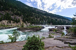
Kootenai Falls is a waterfall on the Kootenai River located in Lincoln County, Montana, just off U.S. Route 2. It is the largest undammed waterfall in the state and one of the largest waterfalls in the United States by flow rate. The falls is accessed by a foot trail from the parking area next to the highway.

St. Richard's Church is a Gothic Revival former Catholic church located in Columbia Falls, Montana, United States, in the Diocese of Helena.
48°21′42″N114°11′02″W / 48.3618°N 114.1838°W
| | This article about a bridge in Montana is a stub. You can help Wikipedia by expanding it. |