
Lake Sharpe is a large reservoir impounded by Big Bend Dam on the Missouri River in central South Dakota, United States. The lake has an area of 56,884 acres (230.20 km2) and a maximum depth of 78 ft (24 m). Lake Sharpe is approximately 80 mi (130 km) long, with a shoreline of 200 mi (320 km). Lake Sharpe is the 54th largest reservoir in the United States. The lake starts near Ft. Thompson and stretches upstream to Oahe Dam, near Pierre. The lake is located within the following counties: Buffalo, Lyman, Hyde, Hughes, and Stanley. The Big Bend of the Missouri is about 7 miles (11 km) north of the dam.

The Oahe Dam is a large earthen dam on the Missouri River, just north of Pierre, South Dakota, United States. The dam creates Lake Oahe, the fourth-largest man-made reservoir in the United States. The reservoir stretches 231 miles (372 km) up the course of the Missouri to Bismarck, North Dakota. The dam's power plant provides electricity for much of the north-central United States. It is named for the Oahe Indian Mission established among the Lakota Sioux in 1874.

Lake Oahe is a large reservoir behind Oahe Dam on the Missouri River; it begins in central South Dakota and continues north into North Dakota in the United States. The lake has an area of 370,000 acres (1,500 km2) and a maximum depth of 205 ft (62 m). By volume, it is the fourth-largest reservoir in the US. Lake Oahe has a length of approximately 231 mi (372 km) and has a shoreline of 2,250 mi (3,620 km). 51 recreation areas are located along Lake Oahe, and 1.5 million people visit the reservoir every year. The lake is named for the 1874 Oahe Indian Mission.

Pine Flat Dam is a concrete gravity dam on the Kings River in the Central Valley of Fresno County, California United States. Situated about 28 miles (45 km) east of Fresno, the dam is 440 feet (130 m) high and impounds Pine Flat Lake, one of the largest reservoirs in California, in the foothills of the Sierra Nevada just outside the boundary of Kings Canyon National Park. The dam's primary purpose is flood control, with irrigation, hydroelectric power generation and recreation secondary in importance.

Lewis and Clark Lake is a 31,400 acre (130 km²) reservoir located on the border of the U.S. states of Nebraska and South Dakota on the Missouri River. The lake is approximately 25 miles (40 km) in length with over 90 miles (140 km) of shoreline and a maximum water depth of 45 feet (14 m). The lake is impounded by Gavins Point Dam and is managed by the U.S. Army Corps of Engineers, Omaha District.
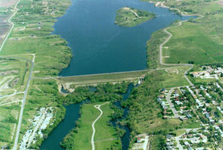
The Jamestown Dam is a rolled-earth dam spanning the James River in Stutsman County in the U.S. state of North Dakota, serving the primary purpose of flood control. It is north of the city of Jamestown, North Dakota. Built from April 1952 to September 1953, the dam measures 1,418 feet (432 m) long at the crest and 85 feet (26 m) high. It impounds the James River to form the Jamestown Reservoir. A small islet lies shortly upstream of the dam, where the James River previously split into two channels.
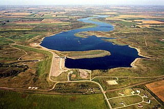
Pipestem Dam is an embankment dam located in Stutsman County, North Dakota, U.S. The dam was constructed by the U.S. Army Corps of Engineers for flood damage reduction, fish and wildlife enhancement, and recreation. The dam impounds the Pipestem River to create the Pipestem Reservoir, also known as Pipestem Lake. Construction of the dam began in June 1971, and was completed in 1973. The dam is located 4 mi (6 km) north of Jamestown, North Dakota. The dam measures approximately 4,000 feet in length, with a maximum height of 107.5 feet from the stream bed to the top of the dam. The dam and reservoir are managed by the U.S. Army Corps of Engineers, with fish and wildlife resources managed by the North Dakota Game and Fish Department.

Heart Butte Dam is a dam in Grant County of southwestern North Dakota. The dam was a project of the United States Bureau of Reclamation completed in 1949, primarily for irrigation and flood control. The earthen dam is 142 feet in height and impounds the Heart River.

Bowman-Haley Dam is an embankment dam located in Bowman County, North Dakota, in the southwestern part of the state. The dam is just over 2 miles north of the South Dakota border.

Renwick Dam is a dam in Akra Township, Pembina County, North Dakota, USA, in the northeastern corner of the state.
The Standing Rock Rural Water System (RWS) is a $30 million water system funded by the American Recovery and Reinvestment Act in 2009 for about 10,000 residents of the Standing Rock Sioux reservation in North Dakota. The RWS includes the Standing Rock Water Treatment and the "Indian Memorial Intake Pump Station, a raw water pipeline, two transmission pipelines and Kline Butte Storage Reservoir." The main regulation reservoir of the Standing Rock Rural Water System is the $3.6 million Kline Butte Storage Reservoir, located southwest of Kenel, South Dakota, which consists of a 5 million gallon ground storage reservoir. Currently, the intake valve for the water system is "located in a shallow part of the Missouri River near Fort Yates, North Dakota, roughly 20 miles from the planned river crossing of the controversial Dakota Access Pipeline also known as the Bakken pipeline. The Bakken oil pipeline Dakota line is to be "buried 92 feet (28 m) below the riverbed in hard clay." A new valve came online in 2016 in Mobridge, South Dakota which is seventy miles south of the proposed Bakken Pipeline Missouri River crossing. This Mobridge intake valve is intended to service the entire Standing Rock Sioux reservation.

