
Deerfield River is a river that runs for 76 miles (122 km) from southern Vermont through northwestern Massachusetts to the Connecticut River. The Deerfield River was historically influential in the settlement of western Franklin County, Massachusetts, and its namesake town. It is the Connecticut River's second-longest tributary in Massachusetts, 2.1 miles (3.4 km) shorter than Metropolitan Springfield's Westfield River.

Moore Reservoir is an impoundment on the Connecticut River located in the communities of Littleton, New Hampshire; Dalton, New Hampshire; Waterford, Vermont; and Concord, Vermont. It occupies approximately 3,181 acres (12.87 km2).
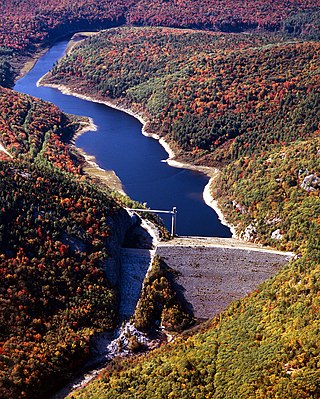
McIndoes Reservoir is a 545-acre (2.21 km2) impoundment on the Connecticut River on the boundary between Vermont and New Hampshire in northern New England. The dam forming the reservoir lies between the communities of McIndoe Falls, Vermont, and Monroe, New Hampshire. Monroe Road crosses the reservoir 600 feet (180 m) north (upstream) of the dam, leading west 0.2 miles (0.3 km) to U.S. Route 5 in McIndoe Falls and east the same distance to New Hampshire Route 135 in the center of Monroe. The next river crossing upstream is a bridge carrying the North Monroe Road, 1.5 miles (2.4 km) north of McIndoe Falls.
Frank D. Comerford Dam is an International Style concrete dam in the Fifteen Mile Falls of the Connecticut River, on the border between the U.S. states of New Hampshire and Vermont. The dam is near Monroe, New Hampshire and Barnet, Vermont. Construction began in 1928 and was completed in 1931. The dam and the power plant were acquired by a subsidiary of Hydro-Québec from Great River Hydro, LLC, in October 2022.

Harriman Dam is a hydroelectric dam in Windham County, Vermont in the town of Whitingham. The water from the dam flows through a penstock to a power generation plant in the adjacent town of Readsboro.
Ball Mountain Dam is a dam in Jamaica, Windham County, Vermont, in the southeastern part of the state.

Townshend Dam is a dam in Townshend, Windham County, Vermont.

North Hartland Dam is a dam on the Ottauquechee River in Hartland, Windsor County, Vermont.
Wrightsville Reservoir is a reservoir located in Washington County, Vermont, United States, as a result of the construction of the Wrightsville Dam built from 1933 to 1935 after the Great Flood of 1927. It is located at the intersection of the municipal borders of three towns, Montpelier, Middlesex, and East Montpelier. It is a popular recreational spot in the summer, for swimming, boating, and fishing in the Montpelier area.

Moore Dam is a major hydroelectric dam on the Upper Connecticut River between Grafton County, New Hampshire and Caledonia County, Vermont in the northeastern United States. The dam is located near Littleton, New Hampshire, and forms the 3,490-acre (1,410 ha) Moore Reservoir. The Moore Station is the largest conventional hydroelectric plant in New England, in terms of installed capacity and average power generation. The dam and reservoir also provide flood control, recreational boating and fishing.

