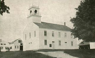
Weare is a town in Hillsborough County, New Hampshire, United States. The population was 9,092 at the 2020 census. It is close to two important New Hampshire cities, Manchester and Concord.

Pine Flat Dam is a concrete gravity dam on the Kings River in the Central Valley of Fresno County, California United States. Situated about 28 miles (45 km) east of Fresno, the dam is 440 feet (130 m) high and impounds Pine Flat Lake, in the foothills of the Sierra Nevada just outside the boundary of Kings Canyon National Park. The dam's primary purpose is flood control, with irrigation, hydroelectric power generation and recreation secondary in importance.
Stockton Lake is a reservoir located in southeastern Cedar County, northeastern Dade County, and southwestern Polk County, Missouri. The lake is 'V' shaped, and covers 39 square miles (100 km2), with 298 miles (480 km) of shoreline. It has three marinas, and 10 public-use areas. It has a "non-development policy," and is surrounded by unspoiled, tree-covered hills. Its banks are owned and operated by the Army Corps of Engineers.

Moore Reservoir is an impoundment on the Connecticut River located in the communities of Littleton, New Hampshire; Dalton, New Hampshire; Waterford, Vermont; and Concord, Vermont. It occupies approximately 3,181 acres (12.87 km2).

Comerford Reservoir is a 1,029-acre (4 km2) impoundment located on the Connecticut River on the boundary between Vermont and New Hampshire in the United States. The reservoir is formed by the Frank D. Comerford Dam in the towns of Monroe, New Hampshire, and Barnet, Vermont, and impounds water into the towns of Littleton, New Hampshire, and Waterford, Vermont, nearly to the Moore Reservoir upstream on the Connecticut.
McIndoes Reservoir is a 545-acre (2.21 km2) impoundment on the Connecticut River on the boundary between Vermont and New Hampshire in northern New England. The dam forming the reservoir lies between the communities of McIndoe Falls, Vermont, and Monroe, New Hampshire. Monroe Road crosses the reservoir 600 feet (180 m) north (upstream) of the dam, leading west 0.2 miles (0.3 km) to U.S. Route 5 in McIndoe Falls and east the same distance to New Hampshire Route 135 in the center of Monroe. The next river crossing upstream is a bridge carrying the North Monroe Road, 1.5 miles (2.4 km) north of McIndoe Falls.

The Piscataquog River is a 34.7-mile-long (55.8 km) river located in southern New Hampshire in the United States. It is a tributary of the Merrimack River, which flows to the Gulf of Maine.
The Blackwater River is a 37.5-mile-long (60.4 km) river located in central New Hampshire in the United States. It is a tributary of the Contoocook River, part of the Merrimack River watershed.

The Millers River is a 52.1-mile-long (83.8 km) river in northern Massachusetts, originating in Ashburnham and joining the Connecticut River just downstream from Millers Falls, Massachusetts. Sections of the river are used for whitewater kayaking, and a section upriver is popular with flatwater racers, and the river is known locally as a good place for pike fishing.
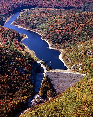
Frank D. Comerford Dam is an International Style concrete dam in the Fifteen Mile Falls of the Connecticut River, on the border between the U.S. states of New Hampshire and Vermont. The dam is near Monroe, New Hampshire and Barnet, Vermont. Construction began in 1928 and was completed in 1931. The dam and the power plant were acquired by a subsidiary of Hydro-Québec from Great River Hydro, LLC, in October 2022.
Ball Mountain Dam is a dam in Jamaica, Windham County, Vermont, in the southeastern part of the state.

North Hartland Dam is a dam on the Ottauquechee River in Hartland, Windsor County, Vermont.

Moore Dam is a major hydroelectric dam on the Upper Connecticut River between Grafton County, New Hampshire and Caledonia County, Vermont in the northeastern United States. The dam is located near Littleton, New Hampshire, and forms the 3,490-acre (1,410 ha) Moore Reservoir. The Moore Station is the largest conventional hydroelectric plant in New England, in terms of installed capacity and average power generation. The dam and reservoir also provide flood control, recreational boating and fishing.

Clough State Park is a public recreation area on the east side of Everett Lake, a 150-acre (60 ha) reservoir formed by a dam on the Piscataquog River, in Weare, New Hampshire. The state park has a 900-foot (270 m) sandy beach, playing fields, and picnic area and offers opportunities for swimming, hiking, fishing, picnicking, and non-motorized boating.

The 2020 New Hampshire Executive Council elections took place on Tuesday, November 3, 2020, to elect all five members of the Executive Council of New Hampshire. The party primaries were held on September 8.

