
The Pick–Sloan Missouri Basin Program, formerly called the Missouri River Basin Project, was initially authorized by the Flood Control Act of 1944, which approved the plan for the conservation, control, and use of water resources in the Missouri River Basin.

Pine Flat Dam is a concrete gravity dam on the Kings River in the Central Valley of Fresno County, California United States. Situated about 28 miles (45 km) east of Fresno, the dam is 440 feet (130 m) high and impounds Pine Flat Lake, in the foothills of the Sierra Nevada just outside the boundary of Kings Canyon National Park. The dam's primary purpose is flood control, with irrigation, hydroelectric power generation and recreation secondary in importance.

The Colorado–Big Thompson Project is a federal water diversion project in Colorado designed to collect West Slope mountain water from the headwaters of the Colorado River and divert it to Colorado's Front Range and plains. In Colorado, approximately 80% of the state's precipitation falls on the West Slope, in the Rocky Mountains, while around 80% of the state's growing population lives along the eastern slope, between the cities of Fort Collins and Pueblo.
Hebgen Lake is a reservoir created by the Hebgen Dam, located in Gallatin County in southwest Montana. It is well known for the 1959 Hebgen Lake earthquake which occurred nearby on August 17, 1959, forming Quake Lake, which is located immediately downstream.

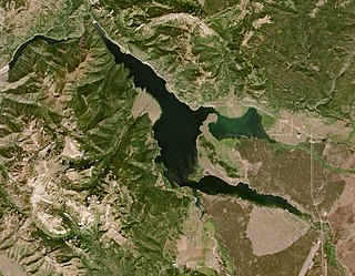
Millerton Lake is an artificial lake near the town of Friant, about 15 mi (24 km) north of downtown Fresno, California, United States. The reservoir was created by the construction of 319 ft high Friant Dam on the San Joaquin River which, with the lake, serves as much of the county line between Fresno County to the south and Madera County to the north.

The Fresno River is a river in Central California and a major tributary of the San Joaquin River. It runs approximately 83 miles (134 km) from the Sierra Nevada Range to the San Joaquin River if measured from the source of Rainier Creek, near Raymond Mountain in Yosemite National Park. Although called the 'Fresno' River, it is one of the largest and longest river systems in Madera County.
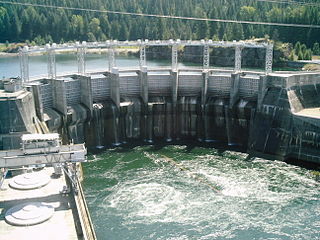
Cabinet Gorge Dam is a concrete gravity-arch hydroelectric dam in the northwest United States, on the Clark Fork River in northern Idaho. The dam is located just west of the Montana border and the Cabinet Gorge Reservoir extends into Montana, nearly to Noxon Rapids Dam. The purpose of the dam is for hydroelectricity.

Holter Dam is a hydroelectric straight gravity dam on the Missouri River about 45 miles (72 km) northeast of Helena, Montana, in the United States. The dam, which was built between 1908 and 1918, is 1,364 feet (416 m) long and 124 feet (38 m) high. The reservoir formed by the dam, Holter Lake is 25 miles (40 km) long and has a storage capacity of 243,000 acre-feet (300,000,000 m3) of water when full. The dam is a "run-of-the-river" dam because it can generate electricity without needing to store additional water supplies behind the dam.

Hauser Dam is a hydroelectric straight gravity dam on the Missouri River about 14 miles (23 km) northeast of Helena, Montana, in the United States. The original dam, built between 1905 and 1907, failed in 1908 and caused severe flooding and damage downstream. A second dam was built on the site in 1908 and opened in 1911 and comprises the present structure. The current Hauser Dam is 700 feet (210 m) long and 80 feet (24 m) high. The reservoir formed by the dam, Hauser Lake, is 25 miles (40 km) long, has a surface area of 3,800 acres (1,500 ha), and has a storage capacity of 98,000 acre-feet (121,000,000 m3) of water when full.

Black Eagle Dam is a hydroelectric gravity weir dam located on the Missouri River in the city of Great Falls, Montana. The first dam on the site, built and opened in 1890, was a timber-and-rock crib dam. This structure was the first hydroelectric dam built in Montana and the first built on the Missouri River. The dam helped give the city of Great Falls the nickname "The Electric City." A second dam, built of concrete in 1926 and opened in 1927, replaced the first dam, which was not removed and lies submerged in the reservoir. Almost unchanged since 1926, the dam is 782 feet (238 m) long and 34.5 feet (10.5 m) high, and its powerhouse contains three turbines capable of generating seven megawatts (MW) of power each. The maximum power output of the dam is 18 MW. Montana Power Company built the second dam, PPL Corporation purchased it in 1997 and sold it to NorthWestern Corporation in 2014. The reservoir behind the dam has no official name, but was called the Long Pool for many years. The reservoir is about 2 miles (3.2 km) long, and has a storage capacity of 1,710 acre-feet (2,110,000 m3) to 1,820 acre-feet (2,240,000 m3) of water.
Toston Dam is a hydroelectric gravity dam located on the Missouri River in Broadwater County, Montana. The dam is 705 feet (215 m) long and 56 feet (17 m) high, and generates 10 megawatts of power. The dam is a "run-of-the-river" dam because it can generate electricity without needing to store additional water supplies behind the dam.

Gibson Dam is a concrete arch dam on the Sun River, a tributary of the Missouri River, about 60 miles (97 km) west of Great Falls, Montana in the United States. Located on the eastern edge of the Rocky Mountains, the dam was built by the U.S. Bureau of Reclamation (USBR) between 1926 and 1929 as part of the Sun River Project to develop about 93,000 acres (38,000 ha) of irrigated land in the Sun River Valley.

