
Garrison Dam is an earth-fill embankment dam on the Missouri River in central North Dakota, U.S. Constructed by the U.S. Army Corps of Engineers from 1947 to 1953, at over 2 miles (3.2 km) in length, the dam is the fifth-largest earthen dam in the world. The reservoir impounded by the dam is Lake Sakakawea, which extends to Williston and the confluence with the Yellowstone River, near the Montana border.
Canton Lake is a lake in Blaine and Dewey Counties in Oklahoma, near Longdale and Canton. Its main source of water is the North Canadian River. It is about an hour away from Enid. The lake serves as a municipal water supply reservoir for Oklahoma City, which pays to have water released from the lake for water-supply purposes.

The Oahe Dam is a large earthen dam on the Missouri River, just north of Pierre, South Dakota, United States. The dam creates Lake Oahe, the fourth-largest man-made reservoir in the United States. The reservoir stretches 231 miles (372 km) up the course of the Missouri to Bismarck, North Dakota. The dam's power plant provides electricity for much of the north-central United States. It is named for the Oahe Indian Mission established among the Lakota Sioux in 1874.

Lake Oahe is a large reservoir behind Oahe Dam on the Missouri River; it begins in central South Dakota and continues north into North Dakota in the United States. The lake has an area of 370,000 acres (1,500 km2) and a maximum depth of 205 ft (62 m). By volume, it is the fourth-largest reservoir in the US. Lake Oahe has a length of approximately 231 mi (372 km) and has a shoreline of 2,250 mi (3,620 km). 51 recreation areas are located along Lake Oahe, and 1.5 million people visit the reservoir every year. The lake is named for the 1874 Oahe Indian Mission.
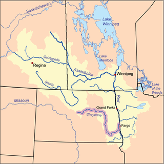
The Sheyenne River is one of the major tributaries of the Red River of the North, meandering 591 miles (951 km) across eastern North Dakota, United States.

Jennings Randolph Lake is a reservoir of 952 acres (3.85 km2) located on the North Branch Potomac River in Garrett County, Maryland and Mineral County, West Virginia. It is approximately eight miles upstream of Bloomington, Maryland, and approximately five miles north of Elk Garden, West Virginia.
Rend Lake is a 13-mile (20.9 km) long, 3-mile (4.8 km) wide reservoir located in Southern Illinois in Franklin and Jefferson Counties near the town of Benton. It contains 18,900 acres (76 km2) of water, stores 185,000 acre-feet (228,000,000 m3) of water, and supplies over 15 million gallons of water per day to 300,000 persons in over 60 communities. The reservoir is up to 35 feet (10.7 m) deep, but its average depth is closer to 9.7 feet (3.0 m). Its elevation is 405 feet (123.4 m) above sea level.

Lewis and Clark Lake is a 31,400 acre (130 km²) reservoir located on the border of the U.S. states of Nebraska and South Dakota on the Missouri River. The lake is approximately 25 miles (40 km) in length with over 90 miles (140 km) of shoreline and a maximum water depth of 45 feet (14 m). The lake is impounded by Gavins Point Dam and is managed by the U.S. Army Corps of Engineers, Omaha District.

Isabella Dam is an embankment dam located in the Kern River Valley, about halfway down the Kern River course, between the towns of Kernville and Lake Isabella in Kern County, California.

Lavon Lake is a freshwater reservoir located in southeast Collin County, Texas, on the East Fork of the Trinity River near Wylie, off State Highway 78. It is commonly called Lake Lavon for commercial and recreational purposes, but Lavon Lake is its official name according to the U.S. Army Corps of Engineers. It was originally called Lavon Reservoir.
Green River Lake is a 8,210-acre (33 km2) reservoir in Adair, Taylor, and Casey counties in Kentucky lying in the section of Kentucky known as the Highland Rim.

The Cochiti Dam is an earthen fill dam located on the Rio Grande in Sandoval County, New Mexico, approximately 50 miles (80 km) north of Albuquerque, New Mexico, in the United States. By volume of material, it is the 23rd largest dam in the world at 62,849,000 yd3 of material, one of the ten largest such dams in the United States, and the eleventh largest such dam in the world. Cochiti Dam is one of the four United States Army Corps of Engineers projects for flood and sediment control on the Rio Grande system, operating in conjunction with Abiquiu Dam, Galisteo Dam and Jemez Canyon Dam.

Fern Ridge Reservoir is a reservoir on the Long Tom River in the U.S. state of Oregon. The reservoir is located approximately 12 miles (19 km) west of Eugene on Oregon Route 126. The reservoir is a U.S. Army Corps of Engineers flood control project encompassing more than 12,000 acres (49 km2) and is a popular site for boating, fishing, and birdwatching.

Lake Darling Dam is an earthen embankment dam on the Souris River in the west north central United States, located twenty miles (30 km) northwest of Minot in Ward County, North Dakota. The dam began impounding water in April 1936 and was completed July of that year; it was created for the purposes of water storage and conservation.

Heart Butte Dam is a dam in Grant County of southwestern North Dakota. The dam was a project of the United States Bureau of Reclamation completed in 1949, primarily for irrigation and flood control. The earthen dam is 142 feet in height and impounds the Heart River.

Bowman-Haley Dam is an embankment dam located in Bowman County, North Dakota, in the southwestern part of the state. The dam is just over 2 miles north of the South Dakota border.

Cold Brook Dam is an earthen dam located near Hot Springs, South Dakota in Fall River County in the southwestern part of the state, in the southern Black Hills.
Cottonwood Springs Dam is a dam in Fall River County, South Dakota in the southwestern part of the state, south of the Black Hills.

Brookville Lake Dam is a dam in Brookville Township, Franklin County, Indiana, just north of Brookville, in the southeastern part of the state.

