
Glen Canyon Dam is a concrete arch-gravity dam in the southwestern United States, located on the Colorado River in northern Arizona, near the city of Page. The 710-foot-high (220 m) dam was built by the Bureau of Reclamation (USBR) from 1956 to 1966 and forms Lake Powell, one of the largest man-made reservoirs in the U.S. with a capacity of more than 25 million acre-feet (31 km3). The dam is named for Glen Canyon, a series of deep sandstone gorges now flooded by the reservoir; Lake Powell is named for John Wesley Powell, who in 1869 led the first expedition to traverse the Colorado River's Grand Canyon by boat.

Lake Mead is a reservoir formed by the Hoover Dam on the Colorado River in the Southwestern United States. It is located in the states of Nevada and Arizona, 24 mi (39 km) east of Las Vegas. It is the largest reservoir in the US in terms of water capacity. Lake Mead provides water to the states of Arizona, California, and Nevada as well as some of Mexico, providing sustenance to nearly 20 million people and large areas of farmland.

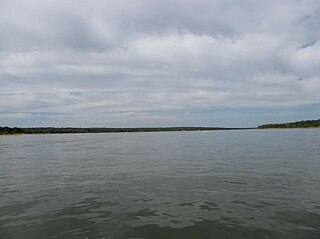
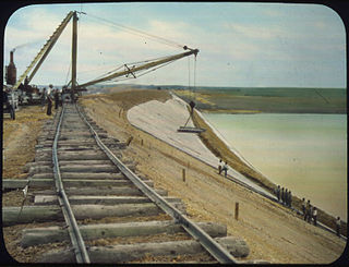
Garrison Dam is an earth-fill embankment dam on the Missouri River in central North Dakota, U.S. Constructed by the U.S. Army Corps of Engineers from 1947 to 1953, at over two miles (3.2 km) in length, the dam is the fifth-largest earthen dam in the world. The reservoir impounded by the dam is Lake Sakakawea, which extends to Williston and the confluence with the Yellowstone River, near the Montana border. The dam and resulting reservoir inundated approximately one-sixth (16.6%) to one-fourth (25%) of Fort Berthold Indian Reservation's land, resulting in the loss of homes, farmland, and community infrastructure for the Three Affiliated Tribes.

The Heart River is a tributary of the Missouri River, approximately 180 miles (290 km) long, in western North Dakota, United States.

The Niobrara River is a tributary of the Missouri River, approximately 568 miles (914 km) long, running through the U.S. states of Wyoming and Nebraska. The river drains one of the most arid sections of the Great Plains, and has a low flow for a river of its length. The Niobrara's watershed includes the northern tier of Nebraska Sandhills, a small south-central section of South Dakota, as well as a small area of eastern Wyoming.

Big Bend Dam is a major embankment rolled-earth dam on the Missouri River in Central South Dakota, United States, creating Lake Sharpe. The dam was constructed by the U.S. Army Corps of Engineers as part of the Pick-Sloan Plan for Missouri watershed development authorized by the Flood Control Act of 1944. Construction began in 1959 and the embankment was completed in July 1963. Power generation began at the facility in 1964 and the entire complex was completed in 1966 at a total cost of $107 million. The hydroelectric plant generates 493,300 kilowatts of electricity at maximum capacity, with an annual production of 969 million kilowatt hours, and meets peak-hour demand for power within the Missouri River Basin.

The Oahe Dam is a large earthen dam on the Missouri River, just north of Pierre, South Dakota, United States. Begun in 1948 and opened in 1962, the dam creates Lake Oahe, the fourth-largest man-made reservoir in the United States. The reservoir stretches 231 miles (372 km) up the course of the Missouri to Bismarck, North Dakota. The dam's power plant provides electricity for much of the north-central United States. It is named for the Oahe Indian Mission established among the Lakota Sioux in 1874.
Lake Thunderbird is a reservoir located in Norman, Oklahoma. The lake was constructed between 1962 and 1965 for the purpose of providing municipal water to the nearby communities of Del City, Midwest City and Norman. It is formed by an earthfill embankment (dam) 7,300 feet (2,200 m) long and up to 144 feet (44 m) high on the Little River. In addition to being a source for drinking water, Lake Thunderbird's secondary uses include numerous recreational activities.

Millerton Lake is an artificial lake near the town of Friant, about 15 mi (24 km) north of downtown Fresno, California, United States. The reservoir was created by the construction of 319 ft high Friant Dam on the San Joaquin River which, with the lake, serves as much of the county line between Fresno County to the south and Madera County to the north.

Pactola Dam is an embankment dam on Rapid Creek in Pennington County, South Dakota, about 10 miles (16 km) west of Rapid City. The dam was completed in 1956 by the U.S. Bureau of Reclamation to provide flood control, water supply and recreation. Along with the nearby Deerfield Dam, it is part of the Rapid Valley Unit of the Pick-Sloan Missouri Basin Program. U.S. Route 385 runs along the crest of the dam. The dam forms Pactola Lake, which at over 1,200 acres (490 ha) is the largest and deepest body of water in the Black Hills.
The Belle Fourche Dam, also known as Orman Dam, is a dam on Owl Creek in Butte County, South Dakota, USA, approximately eight miles east of Belle Fourche, South Dakota, along U.S. Route 212. Its construction created the Belle Fourche Reservoir, the Belle Fourche National Wildlife Refuge, and the Rocky Point Recreation Area.
Dickinson Dam is a dam in Stark County, North Dakota, one and a half miles west of the town of Dickinson.
Box Butte Dam is a dam in the arid northwestern panhandle area of Dawes County, Nebraska.

Bowman-Haley Dam is an embankment dam located in Bowman County, North Dakota, in the southwestern part of the state. The dam is just over 2 miles north of the South Dakota border.
The Standing Rock Rural Water System (RWS) is a $30 million water system funded by the American Recovery and Reinvestment Act in 2009 for about 10,000 residents of the Standing Rock Sioux reservation in North Dakota. The RWS includes the Standing Rock Water Treatment and the "Indian Memorial Intake Pump Station, a raw water pipeline, two transmission pipelines and Kline Butte Storage Reservoir." The main regulation reservoir of the Standing Rock Rural Water System is the $3.6 million Kline Butte Storage Reservoir, located southwest of Kenel, South Dakota, which consists of a 5 million gallon ground storage reservoir. Currently, the intake valve for the water system is "located in a shallow part of the Missouri River near Fort Yates, North Dakota, roughly 20 miles from the planned river crossing of the controversial Dakota Access Pipeline also known as the Bakken pipeline. The Bakken oil pipeline Dakota line is to be "buried 92 feet (28 m) below the riverbed in hard clay." A new valve came online in 2016 in Mobridge, South Dakota which is seventy miles south of the proposed Bakken Pipeline Missouri River crossing. This Mobridge intake valve is intended to service the entire Standing Rock Sioux reservation.

