Glen Ullin, North Dakota

Last updated

Glen Ullin, North Dakota
ND Morton County Glen Ullin.svg
Location of Glen Ullin, North Dakota
Coordinates: 46°48′43″N101°50′00″W / 46.81194°N 101.83333°W / 46.81194; -101.83333
CountryUnited States
State North Dakota
County Morton
Area
[1]
  Total1.05 sq mi (2.72 km2)
  Land1.02 sq mi (2.64 km2)
  Water0.03 sq mi (0.08 km2)
Elevation
[2]
2,097 ft (639 m)
Population
 (2020)
  Total732
  Density719.06/sq mi (277.55/km2)
Time zone UTC-6 (CST)
  Summer (DST) UTC-5 (CDT)
ZIP code
58631
Area code 701
FIPS code 38-30860
GNIS feature ID1036058 [2]
Website glen-ullin.com

Glen Ullin is a city in Morton County, North Dakota, United States. It is part of the "Bismarck, ND Metropolitan Statistical Area" or "Bismarck-Mandan". The population was 732 at the 2020 census. [3]

Contents

History

Glen Ullin was founded in 1883 along the transcontinental route of the Northern Pacific Railway. The name was created by Major Alvan E. Bovay, a Northern Pacific land agent at the time. [4] Glen, the Scottish Gaelic word for "valley," was chosen because of the city's location within a valley, while Ullin was taken from the Thomas Campbell poem Lord Ullin's Daughter . [5] Glen Ullin was originally built up chiefly by Germans from Russia. [6]

Geography

According to the United States Census Bureau, the city has a total area of 1.07 square miles (2.77 km2), of which, 1.04 square miles (2.69 km2) is land and 0.03 square miles (0.08 km2) is water. [7]

Demographics

Historical population
CensusPop.Note
1910 921
1920 875−5.0%
1930 9508.6%
1940 9762.7%
1950 1,32435.7%
1960 1,210−8.6%
1970 1,070−11.6%
1980 1,1255.1%
1990 927−17.6%
2000 865−6.7%
2010 807−6.7%
2020 732−9.3%
2021 (est.)729 [8] −0.4%
U.S. Decennial Census [9]
2020 Census [3]

2010 census

As of the census [10] of 2010, there were 807 people, 358 households, and 192 families residing in the city. The population density was 776.0 inhabitants per square mile (299.6/km2). There were 416 housing units at an average density of 400.0 per square mile (154.4/km2). The racial makeup of the city was 97.3% White, 0.5% Native American, 0.2% Asian, 0.2% Pacific Islander, 0.2% from other races, and 1.5% from two or more races. Hispanic or Latino of any race were 0.4% of the population.

There were 358 households, of which 20.4% had children under the age of 18 living with them, 45.8% were married couples living together, 5.6% had a female householder with no husband present, 2.2% had a male householder with no wife present, and 46.4% were non-families. 40.8% of all households were made up of individuals, and 21.7% had someone living alone who was 65 years of age or older. The average household size was 2.01 and the average family size was 2.74.

The median age in the city was 53.4 years. 17.3% of residents were under the age of 18; 4.1% were between the ages of 18 and 24; 18% were from 25 to 44; 26.3% were from 45 to 64; and 34.2% were 65 years of age or older. The gender makeup of the city was 46.2% male and 53.8% female.

2000 census

As of the census of 2000, there were 865 people, 369 households, and 221 families residing in the city. The population density was 831.2 inhabitants per square mile (320.9/km2). There were 405 housing units at an average density of 389.2 per square mile (150.3/km2). The racial makeup of the city was 99.42% White, 0.23% Native American, and 0.35% from two or more races.

There were 369 households, out of which 22.5% had children under the age of 18 living with them, 54.5% were married couples living together, 4.3% had a female householder with no husband present, and 40.1% were non-families. 37.9% of all households were made up of individuals, and 23.6% had someone living alone who was 65 years of age or older. The average household size was 2.08 and the average family size was 2.77.

In the city, the population was spread out, with 17.9% under the age of 18, 4.3% from 18 to 24, 19.2% from 25 to 44, 19.7% from 45 to 64, and 39.0% who were 65 years of age or older. The median age was 52 years. For every 100 females, there were 86.0 males. For every 100 females age 18 and over, there were 85.9 males.

The median income for a household in the city was $27,688, and the median income for a family was $32,368. Males had a median income of $24,444 versus $16,513 for females. The per capita income for the city was $16,258. About 4.4% of families and 8.3% of the population were below the poverty line, including 10.8% of those under age 18 and 12.3% of those age 65 or over.

Education

Glen Ullin currently operates a K-12 school located on the bypass on the south end of Glen Ullin. Glen Ullin's school mascot is the "Bearcat". The school's nickname was previously the "Rattlers", until the school combined with Hebron high school and a name change took place. Glen Ullin's 1st co-op with Hebron, for football, had the team name of the "Bandits". Glen Ullin is currently combined in football with Beulah.

Notable people

Related Research Articles

<span class="mw-page-title-main">Oliver County, North Dakota</span> County in North Dakota, United States

Oliver County is a county located in the U.S. state of North Dakota. As of the 2020 census, the population was 1,877. Its county seat and only city is Center.

<span class="mw-page-title-main">Ullin, Illinois</span> Village in Illinois, United States

Ullin is a village in Pulaski County, Illinois, United States. The population was 463 at the 2010 census.

<span class="mw-page-title-main">Morton, Minnesota</span> City in Minnesota, United States

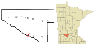
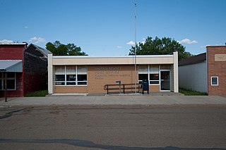
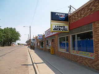
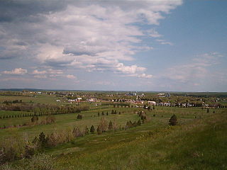
Morton is a city in Renville County, Minnesota, United States. This city is ninety-five miles southwest of Minneapolis. It is the administrative headquarters of the Lower Sioux Indian Reservation. The population was 411 at the 2010 census.

<span class="mw-page-title-main">Hettinger, North Dakota</span> City in North Dakota, United States

Hettinger is a city in, and the county seat of, Adams County, North Dakota, United States. The population was 1,074 at the 2020 census.

<span class="mw-page-title-main">Brinsmade, North Dakota</span> City in North Dakota, United States

For people with the surname, see Brinsmade (surname).

<span class="mw-page-title-main">Esmond, North Dakota</span> City in North Dakota, United States

Esmond is a city in Benson County, North Dakota, United States. The population was 91 at the 2020 census. Esmond was founded in 1901.

<span class="mw-page-title-main">Minnewaukan, North Dakota</span> City in North Dakota, United States

Minnewaukan is a city in Benson County, North Dakota, United States. It serves as the county seat and is fourth largest city in the county, after Fort Totten, Leeds, and Maddock. The population was 199 at the 2020 census. Minnewaukan was founded in 1884.

<span class="mw-page-title-main">Maxbass, North Dakota</span> City in North Dakota, United States

Maxbass is a city in Bottineau County, North Dakota, United States. The population was 89 at the 2020 census. Maxbass was founded in 1905.

<span class="mw-page-title-main">Ayr, North Dakota</span> City in North Dakota, United States

Ayr is a city in Cass County, North Dakota, United States. The population was 11 at the 2020 census. Ayr was founded in 1883.

<span class="mw-page-title-main">Flasher, North Dakota</span> City in North Dakota, United States

Flasher is a city in Morton County, North Dakota, United States. It is part of the "Bismarck, ND Metropolitan Statistical Area" or "Bismarck-Mandan". The population was 217 at the 2020 census. Flasher was founded in 1902.

<span class="mw-page-title-main">Hebron, North Dakota</span> City in North Dakota, United States

Hebron is a city in Morton County, North Dakota, United States. It is part of the "Bismarck, ND Metropolitan Statistical Area" or "Bismarck-Mandan". The population was 794 at the 2020 census.

<span class="mw-page-title-main">New Salem, North Dakota</span> City in North Dakota, United States

New Salem is a city in Morton County, North Dakota, United States. It is part of the "Bismarck, ND Metropolitan Statistical Area" or "Bismarck-Mandan". The population was 973 at the 2020 census. New Salem was founded in 1883.

<span class="mw-page-title-main">Harvey, North Dakota</span> City in North Dakota, United States

Harvey is a city in Wells County, North Dakota, United States. The population was 1,650 at the 2020 census. Harvey was founded in 1893 as a division point by the Soo Line Railway. Harvey is believed to have been named for a director of the Soo Line Railway, Col. Scott William Harvey of Minneapolis, Minnesota.

<span class="mw-page-title-main">Wagner, South Dakota</span> City in South Dakota, United States

Wagner is a city in Charles Mix County, South Dakota, United States. The population was 1,490 at the 2020 census. The city is served by Wagner Municipal Airport as well as YST Transit buses.

<span class="mw-page-title-main">Clear Lake, South Dakota</span> City in South Dakota, United States

Clear Lake is a city in and the county seat of Deuel County, South Dakota, United States. The population was 1,218 at the 2020 census.

<span class="mw-page-title-main">Central City, South Dakota</span> City in South Dakota, United States

Central City is a city in Lawrence County, South Dakota, United States. The population was 93 at the 2020 census.

<span class="mw-page-title-main">Lennox, South Dakota</span> City in South Dakota, United States

Lennox is a city in Lincoln County, South Dakota, United States, located 20 miles (32 km) southwest of Sioux Falls. The population was 2,423 at the 2020 census.

<span class="mw-page-title-main">Carthage, South Dakota</span> City in South Dakota, United States

Carthage is a city in Miner County, South Dakota, United States. The population was 127 at the 2020 census.

<span class="mw-page-title-main">Crooks, South Dakota</span> City in South Dakota, United States

Crooks is a city in Minnehaha County, South Dakota, United States and is a suburb of Sioux Falls. The population was 1,362 at the 2020 census. Crooks was named New Hope until 1904. The town's present name honors W. A. Crooks, a local politician.

<span class="mw-page-title-main">Centerville, South Dakota</span> City in South Dakota, United States

Centerville is a city in Turner County, South Dakota, United States. The population was 918 at the 2020 census. Centerville is part of the Sioux Falls, South Dakota metropolitan area.

References

  1. "ArcGIS REST Services Directory". United States Census Bureau. Retrieved September 20, 2022.
  2. 1 2 U.S. Geological Survey Geographic Names Information System: Glen Ullin, North Dakota
  3. 1 2 "Explore Census Data". United States Census Bureau . Retrieved April 30, 2022.
  4. Wick, Douglas A. "Glen Ullin (Morton County)". North Dakota Place Names. Retrieved May 6, 2011.
  5. "History of Glen Ullin". City of Glen Ullin. Retrieved May 6, 2011.
  6. Federal Writers' Project (1938). North Dakota, a Guide to the Northern Prairie State. WPA. p. 293. ISBN   978-1-62376-033-5.
  7. "US Gazetteer files 2010". United States Census Bureau. Archived from the original on January 12, 2012. Retrieved June 14, 2012.
  8. "City and Town Population Totals: 2020-2021". United States Census Bureau. June 16, 2022. Retrieved June 19, 2022.
  9. United States Census Bureau. "Census of Population and Housing" . Retrieved July 19, 2013.
  10. "U.S. Census website". United States Census Bureau . Retrieved June 14, 2012.
  11. Morton County Historical Society (1975). Peterson, Marion Plath (ed.). Morton prairie roots. Dallas, Texas: Taylor Publishing Co. p. 212. OCLC   2062977.