Driscoll, North Dakota

Last updated

Driscoll, North Dakota
Driscoll Driscoll, North Dakota (9541425776).jpg
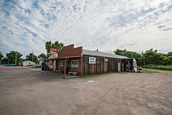
The former Norm's Grocery in Driscoll
USA North Dakota location map.svg
Red pog.svg
Driscoll
Usa edcp location map.svg
Red pog.svg
Driscoll
Coordinates: 46°50′34″N100°08′38″W / 46.84278°N 100.14389°W / 46.84278; -100.14389 [1]
Country United States
State North Dakota
County Burleigh
Area
[2]
  Total0.58 sq mi (1.49 km2)
  Land0.58 sq mi (1.49 km2)
  Water0.00 sq mi (0.00 km2)
Elevation
[1]
1,870 ft (570 m)
Population
 (2020)
  Total68
  Density117.85/sq mi (45.53/km2)
Time zone UTC-6 (Central (CST))
  Summer (DST) UTC-5 (CDT)
ZIP codes
58532
Area code 701
FIPS code [3] 38-20500
GNIS feature ID2628574 [1]

Driscoll is a census-designated place in southeastern Burleigh County, North Dakota, United States. An unincorporated community, it was designated as part of the U.S. Census Bureau's Participant Statistical Areas Program on June 10, 2010. [1] It was not counted separately during the 2000 Census, [4] but was included in the 2010 Census, [5] where a population of 82 was reported. [6] In 2018, Driscoll was counted as a Census Designated Place, and had a population of 78. [7] As of the 2020 Census, the population was reported to be 68. [8]

Contents

Driscoll lies just off Interstate 94, east of the city of Bismarck, the county seat of Burleigh County. [1] it had a post office, with the ZIP code 58532. [9]

Journalist Era Bell Thompson grew up in Driscoll; hers was the only black family in town. [10]

History

Driscoll was named for Frederick Driscoll, a newspaper manager. [11]

In June 2015, The Coal Car Diner closed. Three months later in September 2015, the owners of Norm's Grocery, and the cafe announced their retirement. On October 10, an auction was held and all remaining equipment and materials were sold. The grocery store had been a mainstay of the town, being open for 57 years. The towns Post Office was located in a small portion of the grocery store, which was forced to close as well. Donna Meland was postmaster and operated the cafe, while Norm Meland operated the store. Norm is quoted as saying “I hate to see it all go. It’s the end of the town, you might say." A local resident, Carol Christenson, says “It’ll be a learning experience for us, but it’s not going to be pleasant. We’ll say goodbye with tears in our eyes.” The Bismarck Tribune states: "Times changed. People became more mobile, the big supermarkets opened a half-hour away in Bismarck and the town’s population declined. As of July, there are 98 people living in the town, according to N.D. Home Town Locator." Mail has since been changed to rural service. [12]

Demographics

Historical population
CensusPop.Note
2020 68
U.S. Decennial Census [13]

Related Research Articles

<span class="mw-page-title-main">Burleigh County, North Dakota</span> County in North Dakota, United States

Burleigh County is a county in the U.S. state of North Dakota. As of the 2020 census, the population was 98,458, making it the second-most populous county in North Dakota. Its county seat is Bismarck, the state capital. The county was named for Dakota Territory political figure Walter A. Burleigh.

Sterling is an unincorporated community in Burleigh County, North Dakota, United States at the intersection of Interstate 94 and U.S. Route 83. It is part of the "Bismarck, ND Metropolitan Statistical Area" or "Bismarck-Mandan".

<span class="mw-page-title-main">Bismarck–Mandan</span> Metropolitan area in North Dakota, US

Bismarck–Mandan, colloquially referred to as BisMan, is the metropolitan area composed of Burleigh, Morton, and Oliver counties in the state of North Dakota.

Union Center is a small rural village in Meade County, South Dakota, United States. It is an unincorporated community, which was designated as part of the U.S. Census Bureau's Participant Statistical Areas Program on June 10, 2010. It was not counted separately during the 2000 Census, but is scheduled for inclusion in the 2010 Census. It has the post office which serves the area covered by ZIP code 57787, and three small businesses.

<span class="mw-page-title-main">Whitesboro, New Jersey</span> Populated place in Cape May County, New Jersey, US

Whitesboro is an unincorporated community and census-designated place (CDP) located within Middle Township in Cape May County, in the U.S. state of New Jersey. Until the 2000 census the area had been part of the Whitesboro-Burleigh CDP, which was split in 2010 into separate CDPs for Burleigh and Whitesboro. As of the 2010 United States Census, the CDP's population was 2,205. Whitesboro was founded as a planned residential community for African Americans and has the majority of the township's black population.

<span class="mw-page-title-main">Agency Village, South Dakota</span> Census-designated place in South Dakota, United States

Agency Village is an unincorporated area and census-designated place (CDP) in Roberts County, South Dakota, United States. It is the headquarters of the Sisseton Wahpeton Oyate and home to Sisseton Wahpeton College. Since 2020, the CDP includes the community known as Goodwill. The population of the CDP was 776 at the 2020 census.

<span class="mw-page-title-main">Manning, North Dakota</span> Census-designated place in North Dakota, United States

Manning is a small town in, and the county seat of, Dunn County, North Dakota, United States. Manning was founded in 1908 to serve as the seat of Dunn County, itself organized that year. Its population was not reported in the 2000 census, but was included in the 2020 census, where a population of 47 was given. Its ZIP Code is 58642.

<span class="mw-page-title-main">Nash, North Dakota</span> Census-designated place & Unincorporated community in North Dakota, United States

Nash is a census-designated place and unincorporated community in Walsh County, North Dakota, United States. Its population was 32 as of the 2010 census. The unincorporated community is located in Farmington Township, northwest of Grafton.

<span class="mw-page-title-main">Raleigh, North Dakota</span> Census-designated place in North Dakota, United States

Raleigh is a census-designated place (CDP) in Grant County, North Dakota, United States. An unincorporated community, it was designated as part of the U.S. Census Bureau's Participant Statistical Areas Program on March 31, 2010. It was not counted separately during the 2000 Census, but was included in the 2010 Census, where a population of 12 was reported.

Trenton is an unincorporated community and census-designated place (CDP) in northwestern Williams County, North Dakota, United States. It lies along North Dakota Highway 1804 southwest of the city of Williston, the county seat of Williams County. Its elevation is 1,900 feet (579 m). It has a post office with the ZIP code 58853. The community lies 220 miles north-west of Bismarck. It was first listed as a CDP prior to the 2020 census.

<span class="mw-page-title-main">McLeod, North Dakota</span> Census-designated place & Unincorporated community in North Dakota, United States

McLeod is a census designated place in eastern Ransom County, North Dakota, United States. An unincorporated community, it was designated as part of the U.S. Census Bureau's Participant Statistical Areas Program on March 31, 2010. It was not counted separately during the 2000 Census, but was included in the 2010 Census, where its population was reported to be 27.

<span class="mw-page-title-main">Menoken, North Dakota</span> Census-designated place in North Dakota, United States

Menoken is an unincorporated community and a census-designated place (CDP) in southwestern Burleigh County, North Dakota, United States. It was designated as part of the U.S. Census Bureau's Participant Statistical Areas Program on June 10, 2010. It was not counted separately during the 2000 Census, but was included in the 2010 Census, where a population of 70 was reported.

<span class="mw-page-title-main">Sutton, North Dakota</span> Census-designated place in North Dakota, United States

Sutton is a census-designated place in western Griggs County, North Dakota, United States. An unincorporated community, it was designated as part of the U.S. Census Bureau's Participant Statistical Areas Program on March 31, 2010. It was not counted separately during the 2000 Census, but was included in the 2010 Census, where a population of 17 was reported.

<span class="mw-page-title-main">Spiritwood, North Dakota</span> Census-designated place & Unincorporated community in North Dakota, United States

Spiritwood is a census-designated place (CDP) in eastern Stutsman County, North Dakota, United States. An unincorporated community, it was designated as part of the U.S. Census Bureau's Participant Statistical Areas Program on March 31, 2010. It was not counted separately during the 2000 census, but was included in the 2010 census, where a population of 18 was reported.

<span class="mw-page-title-main">Denhoff, North Dakota</span> Census-designated place & unincorporated community in North Dakota, United States

Denhoff is an unincorporated community and census-designated place in central Sheridan County, North Dakota, United States. The community was designated as part of the U.S. Census Bureau's Participant Statistical Areas Program on March 31, 2010. It was not counted separately during the 2000 Census, but was included in the 2010 Census, where a population of 20 was reported.

Reddell is a census-designated place and unincorporated community in Evangeline Parish, Louisiana, United States. As of the 2010 census it had a population of 733. It is located approximately 2 miles (3 km) north of Mamou along Louisiana Highway 13.

<span class="mw-page-title-main">Overly, North Dakota</span> City in North Dakota, United States

Overly is a city in Bottineau County in the U.S. state of North Dakota. The population was 10 at the 2020 census.

<span class="mw-page-title-main">Burleigh, New Jersey</span> Populated place in Cape May County, New Jersey, US

Burleigh is an unincorporated community and census-designated place (CDP) located within Middle Township in Cape May County, in the U.S. state of New Jersey; Until the 2000 census the area had been part of the Whitesboro-Burleigh CDP, which was split in 2010 into separate CDPs for Burleigh and Whitesboro. As of the 2010 United States Census, the CDP's population was 725.

<span class="mw-page-title-main">Ruthville, North Dakota</span> Census-designated place & Unincorporated community in North Dakota, United States

Ruthville is a census-designated place and unincorporated community in Ward County, North Dakota, United States. Its population was 191 as of the 2010 census. The town was named after Ruth Mackenroth during the Depression, and consisted of a grocery Store, and gas station for area farmers.

Apple Valley is an unincorporated community and census-designated place (CDP) in Burleigh County, North Dakota, United States. It was first listed as a CDP prior to the 2020 census.

References

  1. 1 2 3 4 5 U.S. Geological Survey Geographic Names Information System: Driscoll, North Dakota
  2. "ArcGIS REST Services Directory". United States Census Bureau. Retrieved September 20, 2022.
  3. "US Board on Geographic Names". United States Geological Survey. October 25, 2007. Retrieved January 31, 2008.
  4. U.S. Census Bureau (2003). "Population and Housing Unit Counts, North Dakota" (PDF). 2000 Census of Population and Housing. Government Printing Office . Retrieved July 20, 2008.
  5. U.S. Census Bureau (February 13, 2008). "Census Designated Place (CDP) Program for the 2010 Census—Final Criteria" (PDF). Federal Register . Archived from the original (PDF) on May 8, 2009. Retrieved July 13, 2010.
  6. "2010 Census Redistricting Data (Public Law 94-171) Summary File". American FactFinder . United States Census Bureau . Retrieved May 2, 2011.[ dead link ]
  7. "Driscoll, ND Profile: Facts & Data". northdakota.hometownlocator.com. Retrieved June 4, 2020.
  8. "Explore Census Data". data.census.gov. Retrieved July 15, 2023.
  9. "Free ZIP Code Lookup with area code, county, geocode, MSA/PMSA, population". www.zipinfo.com. Archived from the original on May 17, 2011. Retrieved June 4, 2020.
  10. Crimmins, Jerry. "BLACK EDITOR, AUTHOR ERA BELL THOMPSON, 80". chicagotribune.com. Retrieved June 4, 2020.
  11. "Profile for Driscoll, North Dakota". ePodunk. Archived from the original on June 23, 2017. Retrieved June 21, 2010.
  12. Donovan, Lauren. "Driscoll loses mainstay of business". Bismarck Tribune. Retrieved June 4, 2020.
  13. "Census of Population and Housing". Census.gov. Retrieved June 4, 2016.