Saint Anthony, North Dakota | |
|---|---|
 | |
 Saint Anthony  Saint Anthony | |
| Coordinates: 46°37′01″N100°54′47″W / 46.61694°N 100.91306°W | |
| Country | United States |
| State | North Dakota |
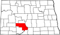
| County | Morton |
| Elevation | 1,801 ft (549 m) |
| Time zone | UTC-6 (Central (CST)) |
| • Summer (DST) | UTC-5 (CDT) |
| ZIP Code | 58566 [2] |
| Area code | 701 |
| GNIS feature ID | 1031088 [1] |
Saint Anthony [1] [2] is an unincorporated town in southeastern Morton County, North Dakota, United States. It lies a short distance to the west of North Dakota Highway 6, south of the city of Mandan, the county seat of Morton County. [3] It has the ZIP code 58566. [4] In 2018, the population was estimated to be less than 30.
Contents
The community is near the site of several transmitter towers of Bismarck broadcast television and radio stations.