
Nebraska Highway 92 is a highway that enters the state from Nebraska's western border at the Wyoming state line west of Lyman, Nebraska, to the state's eastern border on the South Omaha Veterans Memorial Bridge over the Missouri River in Omaha, where it enters Iowa. Nebraska Highway 92 passes, follows, or runs through a number of the state's principal attractions, including Scotts Bluff National Monument, the Oregon Trail, Chimney Rock National Historic Site, Ash Hollow State Historical Park, Lake McConaughy, the Nebraska Sand Hills, and the City of Omaha. Nebraska Highway 92 is the longest state route in the state at a total of 489.1 miles (787.1 km), and is part of a continuous 886-mile (1,426 km) four-state "Highway 92" which begins in Torrington, Wyoming, goes through Nebraska and Iowa and ends in La Moille, Illinois. It is the only Nebraska Highway to run from the west border to the east border of Nebraska; along the way it crosses the Platte River or its tributary North Platte River a total of five times.

South Dakota Highway 127 is a highway that runs from North Dakota Highway 127, northwest of White Rock to South Dakota Highway 10 in Sisseton. It was commissioned around 1980.
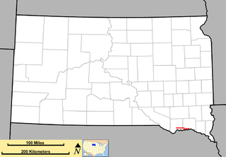
South Dakota Highway 43 (SD 43) is a 1.131-mile-long (1.820 km) state highway that exists entirely in the southern part of Gregory County in the southern part of the U.S. state of South Dakota. It begins as an extension of Nebraska Highway 11 (N-11) at the Nebraska state line south of Fairfax. It travels northwest to an intersection with U.S. Route 18 (US 18) south-southwest of the town.

South Dakota Highway 45 is a state highway that runs north to south across much of central South Dakota, United States. The northern terminus is at the North Dakota border as a continuation of North Dakota Highway 3, and runs south to South Dakota Highway 44 at Platte. It is 198 miles (319 km) in length.

South Dakota Highway 21 (SD 21) is a 9.470-mile (15.240 km) state highway in south-central Hamlin Countym South Dakota, that connects Lake Norden and Hayti.

South Dakota Highway 22 (SD 22) is a 48.546-mile-long (78.127 km) state highway in Hamlin and Deuel counties in South Dakota, United States. It connects Hazel and Clear Lake.
South Dakota Highway 52 is a state route that runs just north of the Missouri River, across southeast South Dakota. It begins at a junction with South Dakota Highway 37 north of Springfield, and terminates in Yankton at U.S. Highway 81, at the junction of 4th and Broadway Streets. It is 37 miles (60 km) in length.

South Dakota Highway 53 is a state route that runs north to south across south central South Dakota. It consists of two separate segments:

South Dakota Highway 15 (SD 15) is a 67.562-mile-long (108.730 km) state highway in the northeastern South Dakota, United States. It connects Clear Lake, Milbank, and Wilmot.
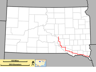
South Dakota Highway 50 is a state route serving south central and southeast South Dakota. The current alignment begins at the junction of South Dakota Highway 34 at "Lee's Corner" east of Fort Thompson, and ends at the Iowa border near Richland, where it continues as Iowa Highway 3. It is about 212 miles (341 km) in length.

South Dakota Highway 75 is a state route located in northwest South Dakota. The southern terminus is at South Dakota Highway 20 west of Bison, and the route runs northerly to the North Dakota border, becoming North Dakota Highway 8. It is 28 miles in length.
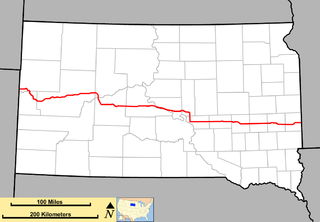
South Dakota Highway 34 is a state route that runs parallel to Interstate 90 across the entire state of South Dakota. It begins at the Wyoming border west of Belle Fourche, as a continuation of Wyoming Highway 24 (WYO 24). The eastern terminus is at the Minnesota border east of Egan, or southwest of Airlie, Minnesota, where it continues as Minnesota State Highway 30 (MN 30). It is just over 419 miles (674 km) in length, making it the longest state highway in South Dakota.

South Dakota Highway 73 is a state route that runs across western South Dakota. It begins at the Nebraska border north of Merriman, Nebraska, as a continuation of Nebraska Highway 61. It runs to the North Dakota border, where it continues as North Dakota Highway 49. It is just more than 255 miles (410 km) in length.

South Dakota Highway 37 is a state route that runs across eastern South Dakota. It begins at the Nebraska border northeast of Niobrara, Nebraska, as a continuation of Nebraska Highway 14. It runs to the North Dakota border north of Hecla, where it continues as North Dakota Highway 1. It is 242 miles (389 km) in length.
In the US state of Iowa, Interstate 29 (I-29) is a north–south Interstate Highway which closely parallels the Missouri River. I-29 enters Iowa from Missouri near Hamburg and heads to the north-northwest through the Omaha–Council Bluffs and the Sioux City areas. It exits the state by crossing the Big Sioux River into South Dakota. For its entire distance through the state, it runs on the flat land between the Missouri River and the Loess Hills.
Interstate 29 (I-29) is a north–south Interstate Highway in the midwestern United States. In the state of South Dakota, I-29 traverses on the eastern side of the state from the Iowa border near Sioux City to the North Dakota border near New Effington. On its route, I-29 passes through western portions of Sioux Falls, the state's largest city. It travels 252.5 miles (406.4 km) in the state, the longest stretch of any of the four states through which it passes. I-229, the highway's lone auxiliary route in South Dakota, serves as a bypass around southern and eastern Sioux Falls.
In the U.S. state of South Dakota, Interstate 90 (I-90) traverses east–west through the southern half of the state.

South Dakota Highway 249 is a state highway in the U.S. state of South Dakota that extends from SD 47 to SD 34 in Buffalo County. The entire highway is located within Fort Thompson and is maintained by the South Dakota Department of Transportation (SDDOT). It is not a part of the National Highway System.

U.S. Highway 16 (US 16) is a 69-mile-long (111 km) east–west U.S. Highway in the western part of the U.S. state of South Dakota. It travels between Yellowstone National Park in Wyoming and Rapid City. In South Dakota, the highway extends from the Wyoming state line near Newcastle, Wyoming to Interstate 90 (I-90) in Rapid City.

