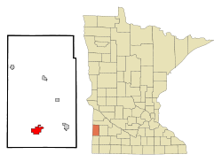
Lake Benton, Minnesota | |
---|---|
Coordinates: 44°15′51″N96°17′21″W / 44.26417°N 96.28917°W | |
Country | United States |
State | Minnesota |
County | Lincoln |
Area | |
• Total | 4.05 sq mi (10.50 km2) |
• Land | 3.21 sq mi (8.30 km2) |
• Water | 0.85 sq mi (2.19 km2) |
Elevation | 1,752 ft (534 m) |
Population (2020) | |
• Total | 687 |
• Density | 214.29/sq mi (82.74/km2) |
Time zone | UTC-6 (Central (CST)) |
• Summer (DST) | UTC-5 (CDT) |
ZIP code | 56149 |
Area code | 507 |
FIPS code | 27-34100 [3] |
GNIS feature ID | 2395586 [2] |
Website | www |
Lake Benton is a city in Lincoln County, Minnesota, United States. The population was 687 at the 2020 census. [4]
Lake Benton is also the name of the approximately seven-mile-long (11 km) lake adjacent to the city of Lake Benton. The town is on the Buffalo Ridge, and is the site for the radio tower of KARZ-FM in Marshall.
The area is the site of Exelon Wind's Norgaard Wind Project. [5]
A post office called Lake Benton has been in operation since 1873. [6] Lake Benton was platted in 1879. [7] The city took its name from nearby Lake Benton. [7] [8] The county seat was located at Lake Benton from 1882 until 1902. [9]
According to the United States Census Bureau, the city has a total area of 4.62 square miles (11.97 km2), of which 3.78 square miles (9.79 km2) is land and 0.84 square miles (2.18 km2) is water. [10]
U.S. Highways 14 and 75 are two of the main routes in the community.
Census | Pop. | Note | %± |
---|---|---|---|
1880 | 184 | — | |
1890 | 513 | 178.8% | |
1900 | 890 | 73.5% | |
1910 | 844 | −5.2% | |
1920 | 944 | 11.8% | |
1930 | 903 | −4.3% | |
1940 | 961 | 6.4% | |
1950 | 863 | −10.2% | |
1960 | 905 | 4.9% | |
1970 | 759 | −16.1% | |
1980 | 869 | 14.5% | |
1990 | 693 | −20.3% | |
2000 | 703 | 1.4% | |
2010 | 683 | −2.8% | |
2020 | 687 | 0.6% | |
U.S. Decennial Census [11] |
As of the census [12] of 2010, there were 683 people, 338 households, and 177 families living in the city. The population density was 180.7 inhabitants per square mile (69.8/km2). There were 383 housing units at an average density of 101.3 per square mile (39.1/km2). The racial makeup of the city was 98.7% White, 0.1% African American, and 1.2% from two or more races. Hispanic or Latino of any race were 0.3% of the population.
There were 338 households, of which 20.1% had children under the age of 18 living with them, 43.5% were married couples living together, 5.0% had a female householder with no husband present, 3.8% had a male householder with no wife present, and 47.6% were non-families. 44.1% of all households were made up of individuals, and 26% had someone living alone who was 65 years of age or older. The average household size was 2.02 and the average family size was 2.76.
The median age in the city was 48.8 years. 21.1% of residents were under the age of 18; 6.2% were between the ages of 18 and 24; 19.5% were from 25 to 44; 24.8% were from 45 to 64; and 28.1% were 65 years of age or older. The gender makeup of the city was 48.8% male and 51.2% female.
As of the census [3] of 2000, there were 703 people, 334 households, and 196 families living in the city. The population density was 183.8 inhabitants per square mile (71.0/km2). There were 365 housing units at an average density of 95.4 per square mile (36.8/km2). The racial makeup of the city was 97.72% White, 1.00% Native American, 0.28% Asian, 0.28% from other races, and 0.71% from two or more races. Hispanic or Latino of any race were 0.71% of the population.
There were 334 households, out of which 21.9% had children under the age of 18 living with them, 50.0% were married couples living together, 5.7% had a female householder with no husband present, and 41.3% were non-families. 39.2% of all households were made up of individuals, and 24.9% had someone living alone who was 65 years of age or older. The average household size was 2.09 and the average family size was 2.78.
In the city, the population was spread out, with 21.6% under the age of 18, 5.4% from 18 to 24, 21.8% from 25 to 44, 22.3% from 45 to 64, and 28.9% who were 65 years of age or older. The median age was 47 years. For every 100 females, there were 89.0 males. For every 100 females age 18 and over, there were 82.5 males.
The median income for a household in the city was $29,583, and the median income for a family was $36,750. Males had a median income of $29,125 versus $21,750 for females. The per capita income for the city was $15,922. None of the families and 5.7% of the population were living below the poverty line, including no under eighteens and 12.2% of those over 64.
Mount Auburn is a city in Benton County, Iowa, United States. The population was 162 at the time of the 2020 census. It is part of the Cedar Rapids Metropolitan Statistical Area.
Alberta Township is a township in Benton County, Minnesota, United States. The population was 818 as of the 2010 census.
Foley is a city and the county seat of Benton County, Minnesota, United States. The population was 2,711 at the 2020 census.
Gilman is a city in Benton County, Minnesota, United States. The population was 224 at the 2010 census. It is part of the St. Cloud Metropolitan Statistical Area.
Langola Township is a township in Benton County, Minnesota, United States. The population was 906 as of the 2010 census. Langola Township was organized in 1858.
Mayhew Lake Township is a township in Benton County, Minnesota, United States. The population was 831 as of the 2010 census. Mayhew Lake Township was named for George V. Mayhew, an early settler of Benton County who became a state legislator.
Minden Township is a township in Benton County, Minnesota, United States. The population was 1,514 as of the 2020 census. Minden Township was organized in 1858.
Rice is a city in Benton County, Minnesota, United States. The population was 1,275 at the 2010 census. Its zip code also encompasses Graham, Langola, and Watab townships.
Sauk Rapids Township is a township in Benton County, Minnesota, United States near the Mississippi River. The population was 584 at the 2010 census.
St. George Township is a township in Benton County, Minnesota, United States. The population was 1,153 as of the 2010 census.
Watab Township is an urban township in Benton County, Minnesota, United States, located north of the mouth of Watab Creek on the opposite side of the Mississippi River in Sartell. The population was 3,093 as of the 2010 census.
Waconia Township is a rural township in Carver County, Minnesota, United States. The population was 1,284 as of the 2000 census.
Young America Township is a rural township in Carver County, Minnesota, United States. The population was 838 as of the 2000 census. Although dominated by agriculture, it was also home to a rebate-processing center for the Young America Corporation until 2015.
Lake Shore is a city in Cass County, Minnesota, United States. The population was 1,056 at the 2020 census. It is part of the Brainerd Micropolitan Statistical Area.
Lake Bronson is a city in Kittson County, Minnesota, United States. The population was 178 at the 2020 census. Lake Bronson State Park is nearby.
Lake Benton Township is a township in Lincoln County, Minnesota, United States. The population was 244 at the 2000 census.
Ruthton is a city in Pipestone County, Minnesota, United States. The population was 241 at the 2010 census.
Hoyt Lakes is a city in Saint Louis County, Minnesota. The population was 2,020 at the time of the 2020 census.
Fifty Lakes is a city in Crow Wing County, Minnesota, United States. The population was 387 at the 2010 census. It is part of the Brainerd Micropolitan Statistical Area.
Minnesota Lake is a city in Blue Earth and Faribault counties in the State of Minnesota. The population was 661 at the 2020 census. The bulk of the city is in Faribault County; a small part extends into Blue Earth County.