This article needs additional citations for verification .(February 2013) |
Hole in the Mountain Prairie is a preserved remnant of the tallgrass prairie in southwestern Minnesota. It is owned and administered by The Nature Conservancy.
This article needs additional citations for verification .(February 2013) |
Hole in the Mountain Prairie is a preserved remnant of the tallgrass prairie in southwestern Minnesota. It is owned and administered by The Nature Conservancy.
Hole in the Mountain Prairie is located on Buffalo Ridge near the town of Lake Benton in Lincoln County, southwestern Minnesota. It spans a valley of about a half-mile in width, with a total area of 1,364 acres (5.5 km2). [1]
The preserve is home to about 60 species of grasses and emergent vegetation, and about 200 species of wildflowers. Trees are a minor feature, with only about 10 species present. [1]
Whitetail deer, foxes, and numerous rodents are present, but The Nature Conservancy touts the butterflies of Hole in the Mountain as the most unusual and significant of its creatures.[ citation needed ] In 2017 an attempt was made by the Minnesota Zoo to reintroduce the nearly-extinct Dakota Skipper butterfly to Hole in the Mountain, from which it had disappeared in the previous decade. [2]
The preserve is located in a valley of Buffalo Ridge, which is in turn a portion of the Coteau des Prairies, a highland which originates in South Dakota and runs about 200 miles (320 km) south and southeast through part of Minnesota and into northwestern Iowa.[ citation needed ]

The Great Plains, sometimes simply "the Plains", is a broad expanse of flatland in North America. It is located west of the Mississippi River and east of the Rocky Mountains, much of it covered in prairie, steppe and grassland. It is the southern and main part of the Interior Plains, which also include the tallgrass prairie between the Great Lakes and Appalachian Plateau, and the Taiga Plains and Boreal Plains ecozones in Northern Canada. The term Western Plains is used to describe the ecoregion of the Great Plains, or alternatively the western portion of the Great Plains.

Prairies are ecosystems considered part of the temperate grasslands, savannas, and shrublands biome by ecologists, based on similar temperate climates, moderate rainfall, and a composition of grasses, herbs, and shrubs, rather than trees, as the dominant vegetation type. Temperate grassland regions include the Pampas of Argentina, Brazil and Uruguay, and the steppe of Ukraine, Russia and Kazakhstan. Lands typically referred to as "prairie" tend to be in North America. The term encompasses the area referred to as the Interior Lowlands of Canada, the United States, and Mexico, which includes all of the Great Plains as well as the wetter, hillier land to the east.

The Coteau des Prairies is a plateau approximately 200 miles in length and 100 miles in width, rising from the prairie flatlands in eastern South Dakota, southwestern Minnesota, and northwestern Iowa in the United States. The southeast portion of the Coteau comprises one of the distinct regions of Minnesota, known as Buffalo Ridge.

Black Mesa is a mesa in the U.S. states of Colorado, New Mexico, and Oklahoma. It extends from Mesa de Maya, Colorado southeasterly 28 miles (45 km) along the north bank of the Cimarron River, crossing the northeast corner of New Mexico to end at the confluence of the Cimarron River and North Carrizo Creek near Kenton in the Oklahoma panhandle. Its highest elevation is 5,705 feet (1,739 m) in Colorado. The highest point of Black Mesa within New Mexico is 5,239 feet (1,597 m). In northwestern Cimarron County, Oklahoma, Black Mesa reaches 4,973 feet (1,516 m), the highest point in the state of Oklahoma. The plateau that formed at the top of the mesa has been known as a "geological wonder" of North America. There is abundant wildlife in this shortgrass prairie environment, including mountain lions, butterflies, and the Texas horned lizard.

The tallgrass prairie is an ecosystem native to central North America. Natural and anthropogenic fire, as well as grazing by large mammals, were historically agents of periodic disturbance, which regulates tree encroachment, recycles nutrients to the soil, and catalyzes some seed dispersal and germination processes. Prior to widespread use of the steel plow, which enabled large scale conversion to agricultural land use, tallgrass prairies extended throughout the American Midwest and smaller portions of southern central Canada, from the transitional ecotones out of eastern North American forests, west to a climatic threshold based on precipitation and soils, to the southern reaches of the Flint Hills in Oklahoma, to a transition into forest in Manitoba.
The Driftless Area comprises southwestern Wisconsin, southeastern Minnesota, northeastern Iowa, and the extreme northwestern corner of Illinois in the American Midwest. It was never covered by ice during the last ice age, and therefore lacks glacial deposits, also termed drift. Its landscape is characterized by steep hills, forested ridges, deeply carved river valleys, and karst geology with spring-fed waterfalls and cold-water trout streams. Ecologically, the Driftless Area's flora and fauna are more closely related to those of the Great Lakes region and New England than those of the broader Midwest and central Plains regions. The steep riverine landscape of both the Driftless Area proper and the surrounding Driftless-like region are the result of early glacial advances that forced preglacial rivers that flowed into the Great Lakes southward, causing them to carve a gorge across bedrock cuestas, thereby forming the modern incised upper Mississippi River valley. The region has elevations ranging from 603 to 1,719 feet at Blue Mound State Park, and together with the Driftless-like region, covers 24,000 square miles (62,200 km2).

The Jeffers Petroglyphs site is an outcrop in southwestern Minnesota with pre-contact Native American petroglyphs. The petroglyphs are pecked into rock of the Red Rock Ridge, a 23-mile (37 km)-long Sioux quartzite outcrop that extends from Watonwan County, Minnesota to Brown County, Minnesota. The exposed surface is approximately 150 by 650 feet and surrounded by virgin prairie. "The site lies in an area inhabited in the early historic period by the Dakota Indians, and both the style and form of some of the carvings are identical with motifs that appear on Dakota hide paintings and their quill designs and beadwork. Others are foreign to this Plains Indian tradition and seem to be much earlier in origin." Several old wagon trail ruts traverse the site, one of which is believed to be the old stage coach route from New Ulm, Minnesota to Sioux Falls, South Dakota.

The Loess Hills are a formation of wind-deposited loess soil in the westernmost parts of Iowa and Missouri, and the easternmost parts of Nebraska and Kansas, along the Missouri River.

Buffalo River State Park is a state park of Minnesota, United States, conserving a prairie bisected by the wooded banks of the Buffalo River. Together with the adjacent Bluestem Prairie Scientific and Natural Area owned by The Nature Conservancy, it protects one of the largest and highest-quality prairie remnants in Minnesota. With the closest swimming lake to the Fargo–Moorhead metropolitan area, however, it is most popular for swimming and picnicking. The 1,068-acre (432 ha) park is located just off U.S. Route 10 in Clay County, 4.5 miles (7.2 km) east of Glyndon and 14 miles (23 km) east of Moorhead.

Stone State Park is a state park of Iowa, USA, located in the bluffs and ravines adjacent to the Big Sioux River. The park consists of 1,069 acres (433 ha) in Woodbury and Plymouth Counties near Sioux City, and overlooks the South Dakota-Iowa border. Stone Park is near the northernmost extent of the Loess Hills, and is at the transition from clay bluffs and prairie to sedimentary rock hills and bur oak forest along the Iowa side of the Big Sioux River. A variety of prairie plants can be found on the steep slopes and ridges, including yucca, penstemon, rough blazing star, silky aster, and pasque flower. Wild turkey, white-tailed deer, coyote, and red fox are found in the park. Birdlife includes the turkey vulture, barred owl, rufous-sided (eastern) towhee, and the ovenbird. Exposed bedrock in the park is composed of lignite, shale, sandstone, and limestone, and dates to the Cretaceous period; it is rich in marine fossils. The park contains many miles of hiking and equestrian trails, and is a popular destination for day visitors, overnight campers, mountain bike enthusiasts, and picnickers.

The Geography of North Dakota consists of three major geographic regions: in the east is the Red River Valley, west of this, the Missouri Plateau. The southwestern part of North Dakota is covered by the Great Plains, accentuated by the Badlands. There is also much in the way of geology and hydrology.

Buffalo Ridge is a large expanse of rolling hills in the southeastern part of the larger Coteau des Prairies. It stands 1,995 feet (608 m) above sea level. The Buffalo Ridge is sixty miles (97 km) long and runs through Lincoln, Pipestone, Murray, Nobles, and Rock counties in the southwest corner of Minnesota.

North Fork Mountain is a quartzite-capped mountain ridge in the Ridge and Valley physiographic province of the Allegheny Mountains of eastern West Virginia, USA. Kile Knob, at 4,588 feet, is the mountain's highest point, and Panther Knob and Pike Knob are nearly as high.

The Tallgrass Aspen Parkland is an ecoregion located in southeastern Manitoba and northwestern Minnesota. The area is characterized by a mosaic of habitat types, including tallgrass prairie, aspen woodland, sedge meadow wetlands, riparian woodland, and oak savanna. A number of endangered and threatened species occur in the area, including the western prairie fringed orchid and Dakota skipper. One of Minnesota's only wild elk herds utilizes the area as well.

Glacial Ridge National Wildlife Refuge was created on October 12, 2004, the 545th National Wildlife Refuge in the United States. Its creation was the result of cooperation between at least 30 agencies or governmental entities. The creation of the refuge was spearheaded by The Nature Conservancy, and the initial endowment of 2,300 acres (9.3 km2) of land was donated by the Conservancy. In light of its planned final size of 37,756 acres (153 km2), it is described by the US Fish and Wildlife Service as "the largest tallgrass prairie and wetland restoration project in U.S. history."
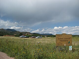
Aiken Canyon Preserve is a 1,621-acre (6.56 km2) Nature Conservancy-managed state property in Colorado. It was first observed and named after Charles Aiken who was a 19th century U.S. surveyor, pioneer, and ornithologist who first surveyed Aiken Canyon in the 1870s and identified more than 75 bird species. The preserve consists of foothills, shrub and woodland ecosystems and is 12.4 miles southeast from Colorado Springs located on the eastern slope of the Rampart Range which is within a smaller foothill system of the Front Range. The surrounding mountain ranges of the Rampart Range and Palmer Divide created the nature preserves sustainable ecosystem. There is also a four-mile (6 km)-loop hiking trail on the preserve.
The Manitoba Tall Grass Prairie Preserve is located in southeastern Manitoba near Gardenton and Vita, this is about 50 kilometres (31 mi) south of Steinbach, Manitoba. It is one of the last remaining stands of tallgrass prairie in Manitoba and is part of the Tallgrass Aspen Parkland conservation area in Manitoba and Minnesota. Several groups and organizations help in land preservation in the Manitoba Tall Grass Prairie such as the Nature Conservancy of Canada, Nature Manitoba, Environment Canada, Manitoba Conservation and the Manitoba Habitat Heritage Corporation.

The Audubon Kern River Preserve is a riparian nature reserve owned by the National Audubon Society in the US state of California, near Weldon in Kern County.

The Niobrara Valley Preserve is a 56,000 acre conservation area in Brown and Keya Paha counties of Nebraska owned by The Nature Conservancy.

Black Earth Rettenmund Prairie is a Wisconsin Department of Natural Resources-designated State Natural Area featuring one of the few remaining dry-mesic prairies in Wisconsin, situated on a low Driftless Area knob and ridge. Despite the prairie's relatively small size, 130 native prairie plant species have been documented on the site. Many of these species are quite showy, including wood lily, shooting star, fringed puccoon, pasque flower, butterfly weed, and compass plant. Several rare species are also found on the site, including pomme-de-prairie, white camas, striped hairstreak, and the state-threatened species rough-stemmed false foxglove and regal fritillary.