Medary, South Dakota

Last updated

Medary, South Dakota
USA South Dakota location map.svg
Red pog.svg
Medary
Location of Medary in South Dakota
Coordinates: 44°12′35″N96°47′11″W / 44.20972°N 96.78639°W / 44.20972; -96.78639 [1]
Country United States
State South Dakota
County Brookings
Township Medary
Founded1857
Founded byDakota Land Company
Named for Samuel Medary
Elevation
[1]
1,575 ft (480 m)
Time zone UTC-6 (Central Time Zone (CST))
  Summer (DST) UTC-5 (CDT)
ZIP code
57006
Area code 605
GNIS feature ID1261042 [1]

Medary is an unincorporated community in Brookings County, South Dakota, United States. [1] Founded in 1857 by the Dakota Land Company, it was one of the first towns in South Dakota. [2] It is not tracked by the U.S. Census Bureau.

Contents

History

Early history

The earliest signs of human activity found in the area date back to 1500 B.C., evidenced through ancient stone artifacts belonging to many different Native American peoples, as well as several burial mounds found in the area. Popular places for early Indian settlements in the county were along the county's many lakes, including the Oakwood Lakes and Lake Campbell; and the Big Sioux River. Sioux Indian tribes later settled the area. The buffalo, elk, and deer herds in the area were important parts of Native American and pioneer life. The area had been traveled by missionaries, explorers, merchants and trappers as early as 1750. The first recorded white man to visit what later became Brookings County was fur-trader Joseph LaFramboise. LaFramboise established a trading post near Flandreau, running it from 1822 to 1827. [2]

Founding and settlement

Medary was the first official town in Brookings County and was one of the first three settlements in South Dakota, along with Flandreau and Sioux Falls. It was named for Governor Samuel Medary of Minnesota Territory. [2] Medary was located and founded in May 1857 [3] by the Dakota Land Company of St. Paul, Minnesota, which was headed by Major Franklin J. DeWitt and Alpheus G. Fuller. On the expedition to locate the claim, the men were joined by engineer Samuel A. Medary, Jr. They became the first residents of the town, staying there for the winter. In early 1858, other settlers began to move to the townsite. [2] However, in June 1858, [3] the settlers were driven away by Yankton and Yanktonnia Indians. Medary was abandoned until 1869, when 10 Norwegian settlers traveled from the east and resettled Medary [2] at a location just north of the old townsite. [3] On July 3, 1871, Brookings County was organized in Martin Trygstad's cabin in Medary. The line originally extended to about 2 miles south of Flandreau. The county lines were redrawn by the territorial legislature on January 8, 1873, where they remain today. [2] The first post office in Brookings County was established in 1871 with Trygstad as postmaster. Medary was also the location of the first school sessions in Brookings County, which were held in volunteers' homes. [3] Medary was the first county seat of Brookings County for a total of eight years, from 1871 to 1879.[ citation needed ]

Later history and today

Medary and the nearby towns of Oakwood and Fountain each hoped that the incoming railroad would decide to go through their town, but they were all bypassed. Instead, the businessmen of Medary and Fountain collaborated and decided to build a town along the planned path of the tracks, which later became Brookings in October 1879. Other towns that sprang up along the railroad were Aurora and Volga. Several businesses moved from Medary and Fountain to Brookings. The town of Medary has become largely abandoned. [2]

A monument was built on the old site of Medary to commemorate the town's existence at the old site, located at the intersection of 471st Avenue (Brookings County Road 77) and 219th Street (Brookings County Road 22). [2]

Geography

Medary is located in Brookings County, approximately 4.5 miles south of Brookings. The Big Sioux River is located nearby. [2]

Climate

Climate data for Medary, South Dakota
MonthJanFebMarAprMayJunJulAugSepOctNovDecYear
Record high °F (°C)65
(18)
69
(21)
85
(29)
93
(34)
106
(41)
105
(41)
109
(43)
106
(41)
102
(39)
93
(34)
77
(25)
68
(20)
109
(43)
Average high °F (°C)23
(−5)
28
(−2)
39
(4)
55
(13)
68
(20)
77
(25)
82
(28)
80
(27)
71
(22)
58
(14)
40
(4)
26
(−3)
54
(12)
Daily mean °F (°C)13
(−11)
18
(−8)
30
(−1)
44
(7)
57
(14)
66
(19)
71
(22)
69
(21)
59
(15)
46
(8)
31
(−1)
17
(−8)
43
(6)
Average low °F (°C)3
(−16)
8
(−13)
21
(−6)
33
(1)
45
(7)
55
(13)
59
(15)
57
(14)
47
(8)
34
(1)
21
(−6)
8
(−13)
33
(0)
Record low °F (°C)−41
(−41)
−41
(−41)
−23
(−31)
−2
(−19)
7
(−14)
28
(−2)
37
(3)
28
(−2)
12
(−11)
−9
(−23)
−22
(−30)
−36
(−38)
−41
(−41)
Average precipitation inches (mm)0.35
(8.9)
0.43
(11)
1.16
(29)
2.13
(54)
2.97
(75)
4.30
(109)
3.25
(83)
3.07
(78)
3.19
(81)
2.05
(52)
0.95
(24)
0.48
(12)
24.33
(616.9)
Source: The Weather Channel (Historical Monthly Averages) [4]

See also

Related Research Articles

<span class="mw-page-title-main">Sioux</span> Native American and First Nations ethnic group

The Sioux or Oceti Sakowin are groups of Native American tribes and First Nations peoples in North America. The modern Sioux consist of two major divisions based on language divisions: the Dakota and Lakota; collectively they are known as the Očhéthi Šakówiŋ. The term "Sioux" is an exonym created from a French transcription ("Nadouessioux") of the Ojibwe term "Nadowessi", and can refer to any ethnic group within the Great Sioux Nation or to any of the nation's many language dialects.

<span class="mw-page-title-main">Moody County, South Dakota</span> County in South Dakota, United States

Moody County is a county in the U.S. state of South Dakota, United States. The population was 6,336 at the 2020 census. Its county seat is Flandreau. The county is named for Gideon C. Moody.

<span class="mw-page-title-main">Brookings County, South Dakota</span> County in South Dakota, United States

Brookings County is a county in the U.S. state of South Dakota. As of the 2020 census, the population was 34,375, making it the fifth-most populous county in South Dakota. Its county seat is Brookings. The county was created in 1862 and organized in 1871.

<span class="mw-page-title-main">Nobles County, Minnesota</span> County in Minnesota, United States

Nobles County is a county in the U.S. state of Minnesota. As of the 2020 census, the population was 22,290. Its county seat is Worthington. Nobles County comprises the Worthington, MN Micropolitan Statistical Area.

<span class="mw-page-title-main">Brookings, South Dakota</span> City in South Dakota, United States

Brookings is a city in Brookings County, South Dakota, United States. Brookings is South Dakota's fourth most populous city, with a population of 23,377 at the 2020 census. It is the county seat of Brookings County, and home to South Dakota State University, the state's largest institution of higher education. Also in Brookings are the South Dakota Art Museum, the Children's Museum of South Dakota, the annual Brookings Summer Arts Festival, and the headquarters of several manufacturing companies and agricultural operations.

<span class="mw-page-title-main">Canton, South Dakota</span> City in South Dakota, United States

Canton is a city in and the county seat of Lincoln County, South Dakota, United States. Canton is located 20 minutes south of Sioux Falls in southeastern South Dakota. Canton is nestled in the rolling hills of the Sioux Valley, providing an abundance of recreational activities with the Big Sioux River bordering the eastern side, Newton Hills State Park to the south, and Lake Alvin to the north. The city was named by Norwegian settler and former legislator James M. Wahl. The population was 3,066 as of the 2020 census.

<span class="mw-page-title-main">Flandreau, South Dakota</span> City in South Dakota, United States

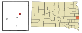
FlandreauFLAN-droo is a city in and county seat of Moody County, South Dakota, United States. The population was 2,372 at the 2020 census. It was named in honor of Charles Eugene Flandrau, a judge in the territory and state of Minnesota. He is credited with saving the community of New Ulm, Minnesota, from destruction during conflict with the Sioux tribe in 1862.

<span class="mw-page-title-main">Samuel Medary</span> Territorial Governor of Minnesota

Samuel Medary was an American newspaper owner and politician.

<span class="mw-page-title-main">Dakota Territory</span> Former organized incorporated territory of the United States (1861–1889)

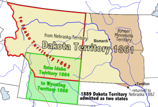
The Territory of Dakota was an organized incorporated territory of the United States that existed from March 2, 1861, until November 2, 1889, when the final extent of the reduced territory was split and admitted to the Union as the states of North and South Dakota.

<span class="mw-page-title-main">Wilmot Brookings</span> American judge

Wilmot Wood Brookings was an American pioneer, frontier judge, and early South Dakotan politician. He was provisional governor of the Dakota Territory, and both the cities of Wilmot and Brookings as well as the county of Brookings, South Dakota are named for him.

The Mdewakanton or Mdewakantonwan are one of the sub-tribes of the Isanti (Santee) Dakota (Sioux). Their historic home is Mille Lacs Lake in central Minnesota. Together with the Wahpekute, they form the so-called Upper Council of the Dakota or Santee Sioux. Today their descendants are members of federally recognized tribes in Minnesota, South Dakota and Nebraska of the United States, and First Nations in Manitoba, Canada.

<span class="mw-page-title-main">Dakota people</span> Native American people in the mid northern U.S. and mid southern Canada

The Dakota are a Native American tribe and First Nations band government in North America. They compose two of the three main subcultures of the Sioux people, and are typically divided into the Eastern Dakota and the Western Dakota.

<span class="mw-page-title-main">South Dakota Highway 13</span> State highway in South Dakota, United States

South Dakota Highway 13 (SD 13) is a 23.835-mile-long (38.359 km) state highway in Moody and Brookings counties in the U.S. state of South Dakota. It connects Flandreau with Elkton. SD 13 was originally part of SD 11's path.

<span class="mw-page-title-main">History of South Dakota</span> Aspect of history

The history of South Dakota describes the history of the U.S. state of South Dakota over the course of several millennia, from its first inhabitants to the recent issues facing the state.

<span class="mw-page-title-main">Treaty of Old Crossing</span> 1863 and 1864 treaties between the United States and Chippewa

By the Treaty of Old Crossing (1863) and the Treaty of Old Crossing (1864), the Pembina and Red Lake bands of the Ojibwe, then known as Chippewa Indians, purportedly ceded to the United States all of their rights to the Red River Valley. On the Minnesota side, the ceded territory included all lands lying west of a line running generally southwest from the Lake of the Woods to Thief Lake, about 30 miles (48 km) west of Red Lake, and then angling southeast to the headwaters of the Wild Rice River near the low-lying divide separating the watershed of the Red River of the North from the watershed of the Mississippi River. On the North Dakota side, the ceded territory included all of the Red River Valley north of the Sheyenne River. The total land area, roughly 127 miles (204 km) wide east to west and 188 miles (303 km) long north to south, consisted of nearly 11,000,000 acres (45,000 km2) of rich prairie land and forests.

The Flandreau Santee Sioux Tribe are a federally recognized tribe of Santee Dakota people. Their reservation is the Flandreau Indian Reservation. The tribe are members of the Mdewakantonwan people, one of the sub-tribes of the Isanti (Santee) Dakota originally from central Minnesota.

<span class="mw-page-title-main">Flandreau Indian Reservation</span> Indian reservation in United States, Flandreau Santee Sioux

The Flandreau Indian Reservation is an Indian reservation, belonging to the federally recognized Flandreau Santee Sioux Tribe of South Dakota. They are Santee Dakota people, part of the Sioux tribe of Native Americans. The reservation is located in Flandreau Township in central Moody County in eastern South Dakota, near the city of Flandreau.

This timeline of South Dakota is a list of events in the history of South Dakota by year.

References

  1. 1 2 3 4 U.S. Geological Survey Geographic Names Information System: Medary, South Dakota
  2. 1 2 3 4 5 6 7 8 9 "History of Brookings". Brookings Chamber of Commerce. Brookings Area Chamber of Commerce & Convention Bureau. Archived from the original on October 19, 2013. Retrieved October 18, 2013.
  3. 1 2 3 4 "History of Brookings County". Brookings County, South Dakota. Retrieved October 19, 2013.
  4. "Climate Statistics for Medary, SD" . Retrieved October 18, 2013.